
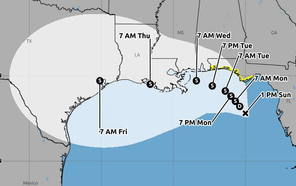
Southeast Texas could face tropical weather late this week as Tropical Depression Two is forecast to turn westward across the Gulf Coast toward Texas. However, forecasters say the system’s eventual path and strength remain highly uncertain.
The National Hurricane Center (NHC) designated the system as Tropical Depression Two on Sunday after it developed a well-defined circulation in the northeastern Gulf of Mexico. Early watches were confined to the Florida Panhandle, but the latest forecast shows the system potentially approaching Southeast Texas on Thursday or Friday.
A westward motion is expected by Wednesday, bringing the system towards Southeat Texas by Thursday or Friday, according to the National Oceanic and Atmospheric Administration (NOAA) and the National Weather Service (NWS) Houston-Galveston outlook.
No tropical watches or warnings had been issued for Texas as of Sunday morning. Before the depression developed a defined center, its exact movement was difficult to determine. Forecasters now expect an area of high pressure over the southern United States to expand eastward and push the system west toward Texas later this week, per the NHC.
The depression is forecast to reach tropical-storm strength as early as Sunday night or Monday. If it does, the depression would become Tropical Storm Bertha.

Tropical Depression Two could bring tropical storm-force winds to Southeast Texas by Wednesday evening with increasing chances for rain and thunderstorms Thursday and Friday. (National Weather Service Houston-Galveston)
“Tropical Storm force winds may arrive in our coastal waters as early as Wednesday evening with increasing chances for rain and thunderstorms Thursday-Friday across SE Texas,” the NWS Houston-Galveston Office wrote.
Forecasters have not yet provided detailed rainfall, wind or flooding forecasts for Southeast Texas. The system’s track, timing and intensity remain especially uncertain beyond Wednesday.
Hurricane Hunter aircraft were scheduled to investigate the depression Sunday. Information collected during that flight could help forecasters better determine its structure, strength and potential path.
As of 10 a.m. Sunday, the system was about 155 miles south of Panama City, Fla., with maximum sustained winds of 30 mph. The depression was moving north-northwest at 2 mph, according to the NHC advisory.
More News
Drama | A real-life $5B treasure hunt is back in a Texas courtroom
Lists | 20 Texas schools make U.S. News’ Best Global Universities ranking
Construction | Houston’s White Oak Bayou users brace for months for disruption
| Right-wing activist says Texas kicked him out. Can a judge do that?
For the latest and best from Chron, sign up for our daily newsletter here.
This article originally published at Southeast Texas sees new tropical threat in Gulf Coast.