
Tropical Storm Bertha, which moved ashore across parts of southern Louisiana on Wednesday, is expected to continue traveling west into parts of Texas on Thursday and into early Friday.
The tropical storm is not expected to strengthen because high levels of wind shear and dry air are disrupting the system. However, some local heavy rainfall is possible across parts of the Gulf Coast, along with gusty winds and rough surf.
In San Antonio, the main story on Thursday will be continued high heat, with humidity-driven heat index values expected to rise up to 108 degrees. However, a few isolated storms associated with Bertha will be possible late Thursday and into early Friday. Here’s a close look at what to expect.
A very muggy and warm morning in San Antonio will include temperatures sitting in the lower 80s under partly cloudy skies. Temperatures will rise fast, possibly reaching 90 degrees as early as 10 a.m.
By the late afternoon, temperatures could reach close to 100 degrees in the San Antonio metro area. With oppressive humidity still in the region, those temps will likely feel like they’re between 105 and 110 degrees throughout the late afternoon and into the early evening.
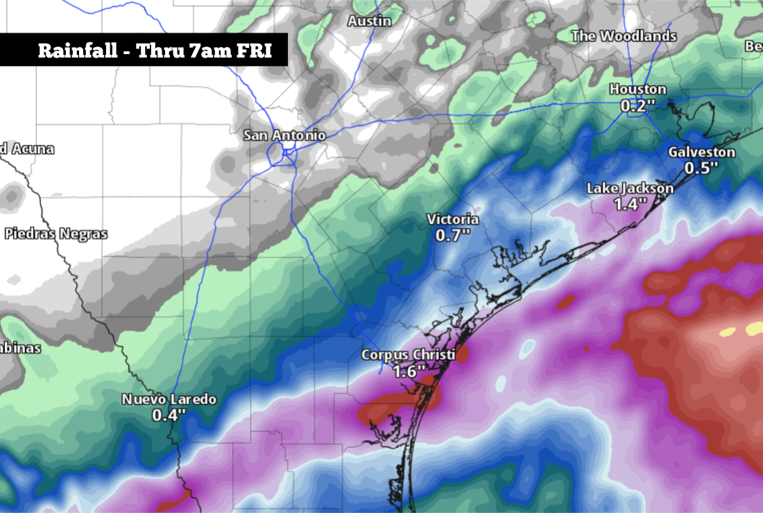
As moisture from Bertha continues into Texas, scattered thunderstorms are expected along the coast during the afternoon and evening. Cities that are most likely to be affected include Beaumont, Houston, Galveston, Victoria, Rockport, and Corpus Christi. Minor coastal flooding is also possible, with a 1- to 3-foot storm surge expected along the northeast Texas Gulf Coast.
San Antonio will stay dry for much of the day. However, a 20% chance of a shower or isolated storm is expected late, mainly after 9 p.m. Rain chances may rise to around 30% overnight, between 2 a.m. and 7 a.m. Friday.
San Antonio rainfall totals are expected to stay very light, if any at all. Most across the metro area will pick up less than a tenth of an inch of rain, with isolated totals greater than a quarter-inch possible in a few spots. The risk of flooding in San Antonio is extremely low.
Rainfall totals will be greater along the coast, where a quarter-inch to 1 inch of rainfall is possible from Galveston to Corpus Christi. Areas west of Corpus Christi — from Kingsville to Hebbronville — could see isolated totals of up to 2-3 inches.
Moisture from Bertha should move out of the region by Friday afternoon, likely giving way to mostly sunny skies and near-average temperatures in the mid-90s. By the weekend, dry weather is expected to continue as temperatures rise slightly. Saturday and Sunday’s temperatures could peak at 96 to 98 degrees in the Alamo City.
Temperatures will continue to rise next week, as high air pressure stays situated over Texas. San Antonio’s afternoon temperatures are likely to be near 98 or 99 degrees by Monday and Tuesday, and finally rising into the triple digits during the middle and end of next week. No rain is expected, either, as skies stay mostly sunny.
Long-range weather models show that intense heat may continue into the first week of August, with temperatures possibly rising above the 100-degree mark most days. Be sure to stay with expressnews.com/weather for daily forecast updates.