
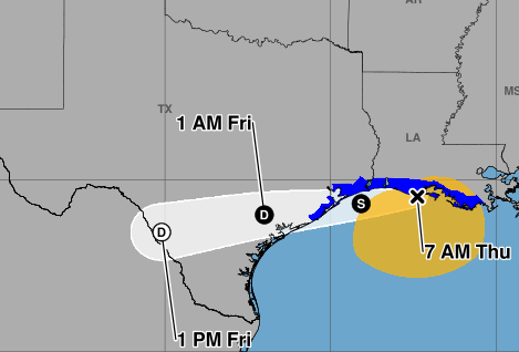
A Tropical Storm Warning has been issued for Chambers, coastal Galveston and coastal Brazoria counties through 6 a.m. Friday, according to the National Weather Service (NWS) Houston-Galveston Office.
“This is where the highest possibility of gusts of 40-45 mph resides, mostly in any rain bands,” NWS Houston-Galveston forecasters wrote in their outlook. “Other than this, significant impacts are not expected.”
As of Thursday morning, the system is moving westward with a maximum sustained wind speed of 45 miles per hour. The storm is expected to eventually push inland this evening.
“Tropical Storm Bertha will make its approach to the Upper Texas Coast late this afternoon into this evening,” forecasters wrote. “However, this system will be rather lopsided with most of the showers and storms displaced to the south of its center.”
Rainfall totals are expected to remain light, with only a low chance of 2 inches or more, primarily along the coast south of Galveston. Some minor coastal flooding will be possible near high tide from the Bolivar Peninsula eastward.
“There is also a high risk of rip currents today along area beaches,” forecasters wrote. “The timing of impacts is mostly this afternoon into this evening as the system quickly weakens upon moving onshore.”
“We’ll see scattered gusty thunderstorms later this afternoon and evening, somewhat like we saw yesterday,” according to Matt Lanza with Space City Weather. “Any of those storms could briefly produce torrential rain and localized wind gusts of 40 to 60 mph (most people will not see that).”
Outside of the tropical impacts, Houston is likely to see another hot weekend with temperatures in the mid to upper 90s north of Interstate 10 and in the low 90s to the south.
“A few residential showers are possible Friday, but overall rain chances dwindle near 10 (percent) or less,” NWS Houston-Galveston forecasters wrote.