
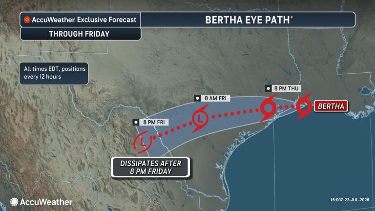
The storm moved ashore along the Texas-Louisiana border on Thursday afternoon, with flooding rain and coastal impacts expected to last through Thursday night.
Published Jul 22, 2026 9:45 AM EDT
|
Updated Jul 23, 2026 2:52 PM EDT
Impacts from Bertha were fairly limited on July 22, but its storm surge did cause significant coastal flooding across Louisiana, Alabama and Mississippi.
Following its first landfall in far eastern portions of St. Bernard Parish, Louisiana, on Wednesday afternoon, Tropical Storm Bertha is now moving inland across Texas, where flooding rain and coastal impacts will be felt through Thursday night.
Even though Bertha is far from some of the powerhouse hurricanes that have struck the central Gulf Coast over the years, its impacts from heavy rain and rising Gulf waters should not be taken lightly.
This image of the Gulf was captured as Tropical Storm Bertha made a second U.S. landfall near the Texas-Louisiana border on Thursday afternoon, July 23, 2026. The center of Bertha was located just to the northeast of the colorful clouds due to northerly wind shear. (AccuWeather Enhanced RealVue™ Satellite)
Bertha is what AccuWeather meteorologists refer to as a homebrew tropical storm because it formed within a few hundred miles of the United States coast—in this case, over the northeastern Gulf. This particular area was under AccuWeather’s watchful eye for well over a week before the storm formed.
“The center of Tropical Storm Bertha spent a brief amount of time off the Louisiana coast Wednesday night into Thursday before moving onshore once more near the Texas-Louisiana border around 2 p.m. ET Thursday,” AccuWeather Lead Hurricane Expert Alex DaSilva said. “The main impacts from this storm will continue to be locally heavy rain, gusty winds along the coast and storm surge that can cause some coastal flooding.”
As of early Thursday afternoon, Bertha had maximum sustained winds of 45 mph with a low-level circulation 75 miles northeast of Galveston, Texas. Similar to most of the storm’s life cycle, this circulation has remained separated from most of the thunderstorms to the south.
As the storm moves inland, some changes in the structure of the storm’s showers and thunderstorms are likely, with bands of heavy rain forecast to move across South Texas, DaSilva stated.
A swath of 2-4 inches can fall across portions of southern Texas, with pockets of heavier rain anticipated along the immediate path of Bertha from around Corpus Christi to Laredo, Texas. The AccuWeather Local StormMax™ rainfall is 15 inches.
Significant rain and flash flooding can extend into the mountainous terrain of northern Mexico at the end of the week.
Localized heavy rain could extend beyond the immediate Texas coast and reach into the central parts of the state, even back to the Texas Hill Country. Localized flash flooding will still be possible in this portion of Texas.
Bertha is a less than one on the AccuWeather RealImpact™ Scale for Hurricanes.
Much of Bertha’s problematic winds will be confined to the Interstate 10 corridor, similar to most of its rain. Tropical storm-force winds of 40-60 mph are most likely to occur briefly in squalls and thunderstorms. These winds can bring down some trees and cause localized power outages.
Have the app? Unlock AccuWeather Alerts™ with Premium+
In terms of coastal impacts, a storm surge of 1-3 feet is anticipated through Galveston Bay, Texas, with an AccuWeather Local StormMax™ surge of 5 feet. Storm surge of 2-3 feet was observed across portions of the Florida Panhandle and coastal portions of Alabama and Mississippi, as well as in southeastern Louisiana earlier this week.
There is the potential for a few severe thunderstorms to occur along Bertha’s westward path into South Texas. With these, a couple of tornadoes and waterspouts could be spawned.
“Even though Bertha has brought and will continue to bring its share of problems from flooding downpours, storm surge and gusty winds, people along the central Gulf Coast should feel fortunate in that wind shear likely prevented the storm from becoming a major hurricane,” DaSilva said.
DaSilva noted that in the wake of Bertha, no additional tropical development is expected across the Atlantic Basin through the rest of July. However, AccuWeather hurricane experts will keep a close eye on the waters of the eastern Gulf and southern Atlantic Seaboard for potential tropical development during the first half of August.
Want next-level safety, ad-free? Unlock advanced, hyperlocal severe weather alerts when you subscribe to Premium+ on the AccuWeather app. AccuWeather Alerts™ are prompted by our expert meteorologists who monitor and analyze dangerous weather risks 24/7 to keep you and your family safer.