
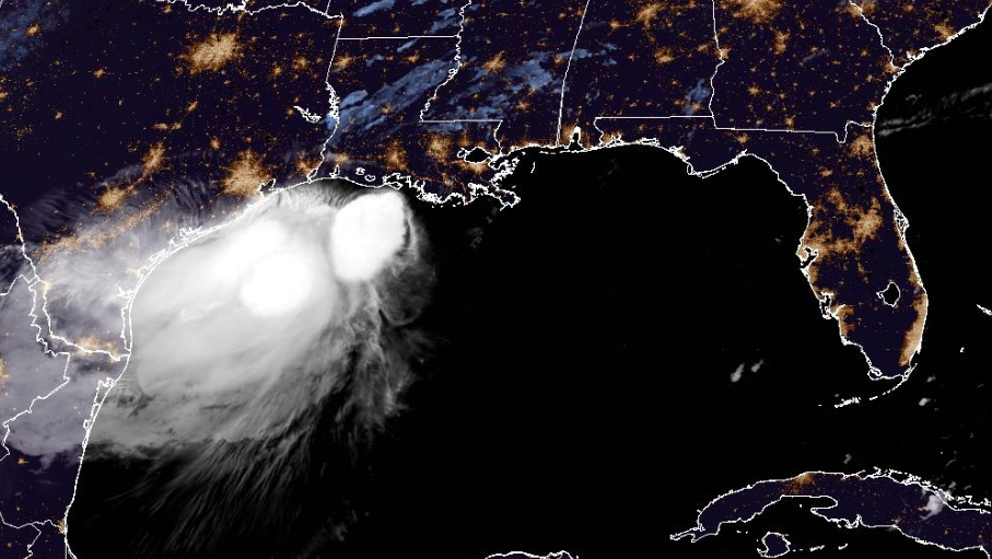
Tropical Storm Bertha makes second landfall near Texas-Louisiana line


Tropical Storm Bertha made a second landfall near the Texas-Louisiana state line Thursday, ending its slow crawl across the U.S. Gulf Coast.
According to the National Hurricane Center, Bertha is about 35 miles north of Galveston, Texas.
The NHC said Bertha is expected to move near or along the Louisiana and upper Texas coasts through this afternoon before tracking farther inland across Texas tonight.
This content is imported from x. You may be able to find the same content in another format, or you may be able to find more information, at their web site.
Tropical Storm Bertha is tracking west south of the Louisiana coast and expected to make landfall along the upper Texas coast later today. Winds remain at 45 mph. The warning for Louisiana east of the Terrebonne/Lafourche line has been dropped. pic.twitter.com/YKyCg2WIxI
— Eric Burris (@EricBurrisWX) July 23, 2026
The system has maximum sustained winds of 40 mph and a minimum central pressure of 1006 mb.
Watches, warnings
Tropical Storm Warning
In effect from the Vermilion/Cameron Parish Line, Louisiana, to Sargent, Texas.
Tropical Storm Watch
No tropical storm watches at this time.Tropical Storm Bertha’s projected path
Bertha is moving toward the west near 10 mph, and this motion with some increase in forward speed is expected during the next day or so, the NHC said.
On the forecast track, the center of Bertha will move across portions of eastern Texas during the next several hours.
Bertha is expected to continue moving generally west to west-northwest through tonight before turning west-southwest on Friday.
Bertha is expected to maintain its current strength today and remain a tropical storm until reaching the upper Texas coast later today.
The system is then forecast to weaken quickly and dissipate over inland Texas by tonight or Friday.
Impacts
Wind: Tropical storm conditions will continue spreading across portions of the northern and northwestern Gulf Coast within the warning area through Thursday.
Rain: Bertha is expected to produce total rainfall amounts of 2 to 4 inches with isolated totals to 6 inches through Thursday night along the Texas Gulf Coast and South Texas. This rainfall may produce isolated flash flooding, especially in urban areas.
Storm surge: The combination of storm surge and the tide will cause normally dry areas near the immediate coast to be flooded by rising waters moving inland from the shoreline.
The water could reach the following heights above ground somewhere in the indicated areas if the peak surge occurs at the time of high tide:
Alabama/Mississippi border to Port Bolivar, TX: 1-3 ftLake Pontchartrain: 1-3 ft
The deepest water will occur along the immediate coast.
RESOURCES | HURRICANE SUPPLIES | SURVIVAL GUIDE | HURRICANE SEASON SPECIAL | WESH LONG-RANGE FORECAST | WHAT TO KNOW ABOUT INSURANCE | GENERATOR SETUP | TESTING CHAINSAWS | POST-STORM RESOURCES | DOWNLOAD WESH 2 APP
Tracking the Tropics
Stay with WESH 2 online and on-air for the most accurate Central Florida weather forecast.
Download the WESH 2 News app to get the most up-to-date weather alerts.
The First Warning Weather team includes First Warning Chief Meteorologist Tony Mainolfi, Eric Burris, Cam Tran and Victoria Wisniewski.
>> 2026 hurricane season | WESH long-range forecast
>> Download Very Local | Stream Central Florida news and weather from WESH 2
RESOURCES | HURRICANE SUPPLIES | SURVIVAL GUIDE | HURRICANE SEASON SPECIAL | WESH LONG-RANGE FORECAST | WHAT TO KNOW ABOUT INSURANCE | GENERATOR SETUP | TESTING CHAINSAWS | POST-STORM RESOURCES | DOWNLOAD WESH 2 APP