
Houston may be just days away from its first prolonged stretch of 100-degree heat this summer, but history shows it’s arriving right on schedule.
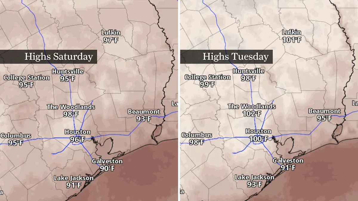
The forecast through the weekend is about as straightforward as summer weather gets. Sunshine will dominate, rain chances remain scarce and afternoon temperatures will climb into the upper 90s before likely reaching 100 degrees across much of Southeast Texas early next week.
HEAT TRACKING TOOL: In 2025, Houston launched a city data dashboard to track heat-related ER visits, health risks.
With little day-to-day change expected, the more interesting story may be what history says about Houston’s hottest weather. While triple-digit heat can happen anytime from June into late September, the city is entering the climatological sweet spot for 100-degree temperatures.
Weekend forecast: Turning up the heat
Saturday will feature mostly sunny skies with only a stray afternoon shower or thunderstorm. Temperatures will reach the upper 90s across much of the Houston area, with a few inland communities flirting with 100 degrees.
Afternoon heat index values are expected to range between 105 and 110 degrees. While that’s just below the National Weather Service’s criteria for a heat advisory for now, the heat will still be dangerous if you spend time outdoors or perform strenuous activities during the hottest part of the day.
Forecast confidence also continues to increase that Houston could see several consecutive days of triple-digit temperatures beginning early next week as high air pressure strengthens over Texas.
How long is Houston’s 100-degree season?
Despite Houston’s reputation for oppressive summers, the city’s window for triple-digit temperatures is surprisingly short.
BECOMING MORE COMMON:
When does Houston usually hit 100 degrees? The answer is changing.
On average, Houston records its first 100-degree day around July 19 and its last around Aug. 10, meaning the typical 100-degree season lasts only about 23 days. This year’s first 100-degree day came on July 22, only a few days later than average.
That doesn’t mean we won’t ever get triple-digit heat outside that window. Houston’s earliest date for a 100-degree day is June 2, when that happened in 2011. The latest date for a 100-degree day was Sept. 27 in 2005, highlighting just how much the season can vary from year to year.
Do all Houston summers reach 100 degrees?
Not quite. While 100-degree temperatures have become much more common in recent decades, they’re still not a guarantee. Houston’s climate records show many summers – particularly before the 1990s-never reached the century mark. Even so, only four of the past 30 years have failed to record at least one 100-degree day, underscoring just how much more common triple-digit heat has become in the modern climate.
That’s one reason next week’s forecast is noteworthy. If the current outlook holds, Houston won’t just record another 100-degree day – it could experience its first prolonged stretch of triple-digit heat this summer, arriving almost exactly when history suggests it’s most likely.
Subscribe
There’s more to Houston with the Chronicle. Subscribe today for just 25¢.
This article originally published at 100-degree heat is just starting in Houston – and right on schedule, weather history says.