
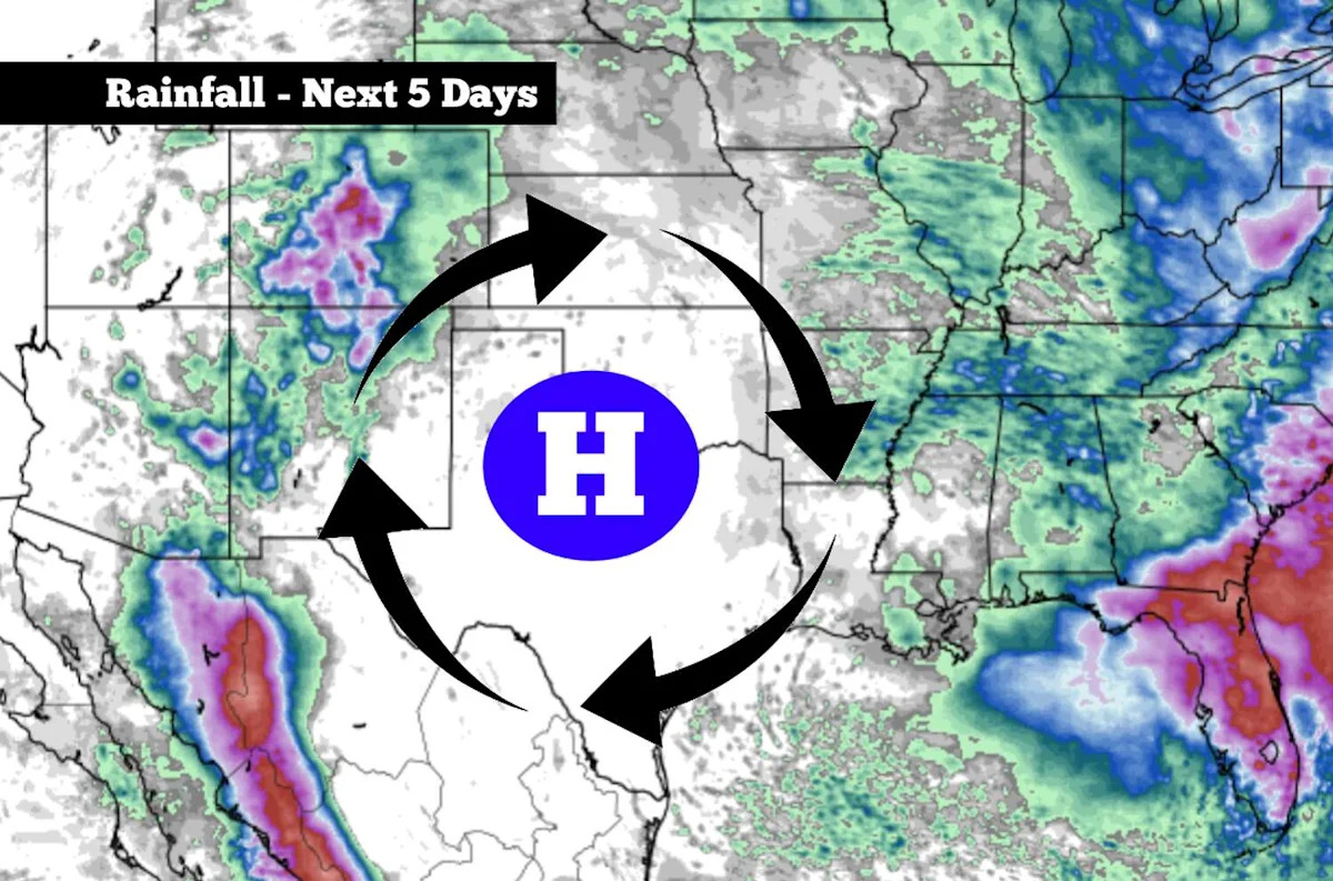
A strong high-pressure system will strengthen over Texas this week, bringing dry weather and triple-digit temperatures to much of the state.
At the same time, weak atmospheric disturbances will rotate clockwise around the edge of the high-pressure system, triggering thunderstorms over neighboring states, such as New Mexico and Arkansas.
Meteorologists often refer to this circumstance as the “ring of fire.” While not an official meteorological term, the name is based on the way thunderstorms form a ring around the edge of a high-pressure system. Areas beneath the center of the high pressure, where sinking air suppresses cloud formation, are often left with sunny skies, no rainfall and intense heat.
This weather pattern is expected to last all week. Parts of North Texas – which will be near the center of high pressure – could see temperatures rise to as high as 106 degrees by the middle of the week. Farther south, San Antonio won’t be quite that hot, but steady temperature increases are expected through the end of the week.

Shown are the expected high temperatures across Texas by Wednesday afternoon. (Pivotal Weather)
San Antonio forecast
Sunday: This will likely be the “coolest” day of the week for San Antonio. Sunday morning will start with partly cloudy skies with low temperatures in the mid- to upper 70s. By the middle of the day, skies will become mostly sunny, with temperatures rising to around 90 degrees by noon.
Afternoon high temperatures are expected to top out at 96 degrees, which is near the average for late July. However, elevated humidity levels will cause the heat index – which tracks how high temperatures feel – to reach to as high as 102 degrees by the late afternoon. If you have outdoor plans, be sure to stay hydrated and take frequent breaks in air-conditioned spaces.

Shown are the expected high temperatures across the region on Sunday. (Pivotal Weather)
Heat building: By Monday, temperatures are expected to rise by a degree or two, reaching high temperatures of up to 98 degrees in San Antonio. Similar conditions are expected on Tuesday, with highs once again hitting the upper 90s.
From Wednesday through Friday, high temperatures are likely to reach nearly 100 degrees each day in San Antonio. Heat index values will be slightly higher, rising to between 102 and 105 degrees each afternoon. Low temps will also stay consistent, hovering in the mid- to upper 70s.
Many parts of Texas will be even hotter, including North Texas, West Texas and the Panhandle. In the DFW Metroplex, high temperatures are expected between 103 and 106 each day this week, likely coming close to record-breaking territory.
There are no chances of rain anywhere across the state. Some cloud-cover is possible each morning, but afternoon skies will stay mostly sunny.
Any changes coming?
High heat is expected to continue into Saturday, with highs once again near 100 degrees in San Antonio. However, by next Sunday and Monday (Aug. 2-3), long-range models show that high pressure may temporarily swing farther west, bringing an opportunity for a few scattered showers and storms in South-Central Texas.
At this point, rain chances are still low, at no higher than 30% in San Antonio. However, those chances could rise or fall as new weather model data becomes available. Be sure to check expressnews.com/weather for daily updates.
Subscribe
There’s more to San Antonio with the Express-News. Subscribe today for just 25¢.
This article originally published at A ‘ring of fire’ weather pattern is coming for Texas. Here’s what that means..