
In some ways, Interstate 35 has always been with us.
While the current construction to widen and lower the freeway through Central Austin challenges and vexes us, its north-south axis, running parallel to the steep Balcones Escarpment to the west, puts it on a path that dates back thousands of years.
The Indigenous Tonkawa, Coahuiltecan, Apache and other tribes blazed various north-south trails, some of which connected the major Central Texas springs in what are now Austin, San Marcos, New Braunfels and San Antonio.
Article continues below this ad
The Spanish borrowed the existing Native American trails to establish El Camino Real de los Tejas, a braided pathway with optional routes that led from Mexico across the Rio Grande to missions and presidios in what is now East Texas and western Louisiana. They, too, tended to avoid the rugged Balcones Escarpment to the west.
Along certain threads, El Camino predicted the future route of Interstate 35.
Construction to widen and lower Interstate 35 through Central Austin is underway.
Jay Janner / American-Statesman
The first roads through Austin
After Austin was founded as the capital of the Texas Republic in 1839, most Austin traffic — on foot, horseback or ox-drawn wagon — traveled on east-west routes to and from the more settled and populated regions of Texas nearer the Gulf Coast.
Article continues below this ad
Still, settlers needed an improved north-south route between San Antonio, the former provincial capital and periodically the biggest Texas city, and Austin. Again, this rough road ran along the ancient paths. Traces of it survive as the Old San Antonio Road, now just west of the current freeway in South Austin.
During the 1840s, Texas settlers founded new hubs in Dallas, Fort Worth and Waco. This was well before the arrival of the railroad in this part of Texas. Thus, a road left Austin for these northerly destinations.
A cattle drive through Wimberley Town Square during the 1930s. Now, this is not the strand of the trail that followed the future Interstate 35 route, but it shows how the drives went through towns like Austin.
Austin 360
Foreshadowing today’s highway, the Native American paths and El Camino Real were rarely single-route roads. There might be an “upper” road along a higher route that meant more rugged land but easier ways to cross streams and rivers, and a “lower” one that might have been the best choice during dry seasons when rivers downstream were low.
Article continues below this ad
During the 1870s, cowboys drove cattle from South Texas up the Chisholm Trail, much of which followed routes later taken by builders of Interstate 35.
At the turn of the last century, workers paved a portion of these roads — some of the hardest work ever done by any Texans and without today’s construction equipment — while they built more bridges, not unlike the Waco Suspension Bridge, the largest such single-span suspension bridge when it was completed in 1870. Some of those bridges closely approximated the future path of the interstate.
Enter the automobile
The real boom in Texas road construction, however, began in the 1920s and ‘30s in answer to the mass production and purchase of cars and trucks. The Texas Highway Department (TxDOT) was founded just before this burst of activity in 1917.
Article continues below this ad
On April 4, 1917, Texas proposed State Highway 2 on parts of the old track that would eventually become Interstate 35.
The Interregional Highway over Airport Boulevard, 1952.
Austin History Center
That route from Laredo to Wichita Falls through Austin and beyond was designated U.S. Highway 81 in 1926.
Roads like it were hardly modern throughways. Some, such as the road between Austin and San Antonio, remained a single lane.
Article continues below this ad
Not two single lanes, one going each direction. A single lane.
Along certain stretches, a driver pulled over to avoid colliding with oncoming traffic, remembered Austin resident John Garza, now in his late 90s, who told the Statesman during a 2021 interview that it took all day to reach his relatives in San Antonio by car.
This would not do during wartime.
During the 1920s, road planners were already dreaming of what would become the interstate system. Thirty years later, the Federal-Aid Highway Act of 1956 called for a 41,000 -mile interstate highway system and authorized $25 billion to help build it.
Article continues below this ad
Why build interstates?
March 29, 1962: Ribbon-cutting ceremony for Interstate 35.
TxDOT
The original aim was to avoid cities in order to transport troops and materials quickly from coast to coast, an American version of Germany’s autobahn.
That didn’t happen. In fact, among the first stretches of the future Interstate 35 pushed through Central Austin in the late 1940s when it was known as the Interregional Highway. Alongside downtown, it followed the route of East Avenue, a wide, green boulevard sketched out in the city’s original 1839 plan.
Article continues below this ad
This Interregional Highway looked to traffic engineers like a futuristic trip into friction-free travel.
Immediately, however, people realized that it divided old communities, fortified racial color lines — intentionally or not — fired demand for vehicular traffic and subsidized suburban sprawl. Similar urban catastrophes befell cities all across the country, with the worst consequences suffered by communities of color who lacked the political power to stop them.
As TxDOT makes the biggest alterations on Interstate 35 in Austin since the 1970s and ’80s, when the now-doomed upper decks were added, and then the freeway was widened from four to six lanes, we can look back on this thoroughfare through the ages.
This time, efforts have been made to “cap and stitch” parks and other amenities above the central stretch of the freeway, which will be lowered below street level.
Article continues below this ad
In 2021, Marian O’Brien, a resident of the Cherrywood neighborhood, protested at Stars Cafe ongoing plans to expand Interstate 35.
Jay Janner / American-Statesman
The University of Texas quickly realized that it should — and could — transform its divided campus with such a system. The city of Austin, always stretched for funds, committed to sections through downtown, but the current federal administration withdrew its grant contributions.
In order to mend this generations-old wound to our physical and social environment, the Austin City Council recently voted to the build the framework for “cap and stitch,” according to TxDOT’s schedule. By doing this, council members placed bets that hundreds of millions of dollars will become available someday.
Interstate 35 through the ages
Interstate 35 has been a daily part of Austin life for more than 60 years. Yet its story goes back centuries.
Jay Janner/American-Statesman
To commemorate the latest stage of highway building that has been thousands of years in the making, we offer these images of the road in key stages.
Article continues below this ad
The Spanish Era
El Camino Real de los Tejas National Historic Trail
Austin American-Statesman
Spanish explorers, missionaries, settlers and military personnel used trails blazed by Native Americans between Mexico across the Rio Grande to and from what is now East Texas and western Louisiana. For about half the route, especially below Austin, threads of El Camino Real de los Tejas closely predicted the route of Interstate 35. The aims: To avoid the rugged highlands to the west and the mosquito-infested wetlands along the Gulf Coast.
1800s
The 19th-century trails and improved roads of Texas.
Hardin-Simmons University Library via Portal to Texas History
Nineteenth-century Texas trails and barely improved roads — including the Chisholm Trail of cattle drive fame during the 1870s — often took routes established by earlier Texans. Well into the late 19th century, those included north-south paths east of the Balcones Escarpment that would become part of Interstate 35.
Article continues below this ad
1920s
Texas Highway 2 in the early 1920s before the general route became U.S. 81, then later Interstate 35.
Texas State Library and Archives
Texas State Highway 2 was the first modern attempt to connect the central corridor of Texas from the Rio Grande to the Red River. Like U.S. Highway 81 and Interstate 35 which followed it, Texas 2 used the relatively flat lands east of the Balcones Escarpment that had serviced Native Americans, Spanish, Mexican and early Texas travelers on the north-south route. Laid out in 1917, it was one of the original state highways.
Looking north from 10th Street along a rough and hilly section of East Avenue prior to paving in 1933.
TxDOT
East Avenue, which was part of the original 1839 city plan, was not much to look at during the 1920s, before it was paved and landscaped in 1933. Streets and utilities in East Austin, where people of color were directed to live — a power dynamic endorsed in the technocratic 1928 city plan — remained unimproved for decades. East Avenue at this time was not the main north-south corridor for traffic from San Antonio to Dallas. State Highway 2 and U.S. 81 ran instead up the middle of downtown. Streets such as South Congress Avenue, Congress Avenue, Guadalupe Street and Lamar Boulevard retain markers, such as tourist courts and food outlets, from that period.
Article continues below this ad
1930s
The freeway that became Interstate 35 replaced broad, beautiful East Avenue, which stood between downtown in East Austin. This photo is undated.
TxDOT
For a few years, East Avenue grew into a beautiful, tree-lined boulevard. Informal parks, picnic areas and sports fields made a physically porous dividing line between African American and Mexican American neighborhoods to the east, and downtown and white neighborhoods to the west. It was known as “La Calle Ancha,” or “wide street,” in the Hispanic community. The main landmark was the multi-story Brackenridge Hospital on the west side at 15th Street.
Mid-1900s
By the mid-1900s, U.S. 81 had replaced what had been State Highway 2, which ran ran from Laredo on the Rio Grande to the Red River through Austin. Long portions U.S. 81 and State Highway 2 were turned into Interstate 35.
TxDOT
By the mid-1900s, U.S. 81 had long replaced State Highway 2, which ran from Laredo to east of Wichita Falls through Austin. Long portions U.S. 81 and State Highway 2 were turned into Interstate 35. In some stretches, it was just one lane wide, but by the 1930s, it grew into two lanes with shoulders.
Article continues below this ad
1940s
The first stretch of Interstate 35 through Central Austin was constructed as part of the Interregional Highway. Here at Airport Boulevard, it crossed the Southern Pacific railroad tracks at grade level. The 38 1/2 overpass can be seen in the distance; Hancock Center would rise in the field to the right.
TxDOT
It might surprise even some long-time Austinites that the Interregional Highway that became Interstate 35 was started in the late 1940s. Most of the previous structures removed stood on the west side. At Airport Boulevard, the freeway crossed the Southern Pacific railroad tracks at grade level. “Yes, Austin’s Interstate 35 freeway had an active railroad grade crossing until about 1970,” reads a description of a TxDOT archival image of railroad workers, “since, in the 1950s, the Southern Pacific had been making noise about abandoning the line to Llano and the highway department didn’t want to spend money on a bridge. The railroad is still in place today and is owned by the Capital Metro transit agency.”
1950s
The destruction of East Avenue and structures on the west side of the old boulevard to make way for what became Interstate 35.
TxDOT
One of the last links of the freeway in Austin proper required the demolition of graceful East Avenue and numerous structures. East Avenue lives on in cultural memory as a meeting place that was replaced by the “Great Wall of Interstate 35.” In the current construction project, more of the displaced structures are on the east side, doomed from the outset.
Article continues below this ad
The construction of an overpass at 19th Street, combined with widening projects in 1951, helped to convert East Avenue into what eventually became Interstate 35.
TxDOT
Planned as a controlled-access, 4-to-6-lane interstate highway through downtown Austin, the freeway aligned on East Avenue. The construction cut through a modestly sized city of 132,459 residents as counted in the 1950 U.S. Census. Round Rock, Georgetown, Cedar Park, Leander, Buda and Kyle were rural small towns.
1960s
March 29, 1962: H.C. Petry cutting the “ribbon of girls” at the opening ceremony of Interstate 35.
TxDOT
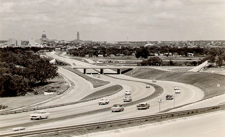
The opening of Interstate 35 through Central Austin in 1962 was considered a social and commercial triumph by some in the community. Texas freeways represented to them personal liberty and business productivity. The former Interregional Highway formally joined the federal interstate system at this point.
Article continues below this ad
This is what traffic engineers dreamed about when they planned Interstate 35. At the same time, it ripped apart communities, hardened racial color lines, encouraged increased traffic and subsidized suburban sprawl.
Austin History Center
1970s
In an attempt to relieve traffic on Interstate 35 in a dense part of Austin, highway engineers built even taller elevated deck from around Airport Boulevard to 15th Street at the start of the 1970s.
TxDOT
Anecdotally, few people will miss the elevated decks of Interstate 35, built in the 1970s to help relieve traffic on the narrow freeway that was already overburdened 10 years after it officially opened. Those upper lanes, however, did provide a singular view of the city, and zooming along them was something of a rite of passage even into the 1980s.
Article continues below this ad
1980s
Not many changes were made to Interstate 35, at least not in Central Austin, during the 1980s. Traffic built up, but the real estate boom of the early ’80s and bust of the late ’80s and its effect on the downtown business district meant more attention was devoted to other projects. Research Boulevard slowly crept from MoPac, first proposed in the 1920s and built in the 1970s, to the northwest. Loop 360, also started in the 1970s, reached the Pennybacker Bridge in 1982, which became a visual symbol of the city for a while. At Mueller Airport, landing jets descended just above Interstate 35, which could be disorienting.
1990s
Vehicle traffic on Interstate 35 slowed as it moved through Austin, Texas, on Thursday, May 21, 1998. In a 24-hour period, an estimated 200,000 vehicles traveled through this stretch of Interstate 35.
HARRY CABLUCK/AP
The tech boom of the 1990s meant extra traffic all over Austin, including on Interstate 35. Suburban sprawl, especially to the north and south of the city, put increased pressure on the stressed freeway. Austin experienced more pollution and ozone action days. As the city’s political class grew more progressive, discussion of the freeway as a historic racial and cultural barrier grew louder. Visionaries already anticipated a time when the “Great Wall of Interstate 35” might come crumbling down.
Article continues below this ad
21st Century
Heavy equipment operates near the Norwood Estate Dog Park along I-35, Aug. 7, 2025.
Sara Diggins/Austin American-Statesman
Rhetoric about traffic on Interstate 35 reached a peak in the early 21st century. A university traffic study suggested that the freeway might be the most congested in the state. That interpretation of the statistics was gleefully embraced by the media and, interestingly, by both advocates for more vehicular lanes and by those who pushed for more public transit. (The ongoing study by the Texas A&M Transportation Institute and TxDOT now regularly ranks Houston and Dallas-Fort Worth freeways among the worst. They dominate the Top 100 in the state, which makes sense to any who travels regularly across Texas.)
Interstate 35 played other, sometimes unexpected roles during the 21st century. The American chapter of the COVID-19 pandemic that lasted from 2020 to 2023 tested the city’s strategies on homelessness and public camping, while it left in place a large and public encampment under the freeway downtown.
Article continues below this ad
A homeless camp under an Interstate 35 overpass in Austin.
Jay Janner / American-Statesman
On May 30 and 31, 2020, protesters stopped traffic on the freeway during a nationwide “Black Lives Matter” protest against police brutality. The responses of local and state law enforcement forces added to the dramatic social and legal divisions.
Austin police confront protesters who blocked Interstate 35 near the Police Department’s headquarters on May 31, 2020. Protesters continued to demonstrate against police violence, and in particular, the death of George Floyd at the hands of Minneapolis police just a few days earlier.
Jay Janner/American-Statesman
While work on Interstate 35 north and south of Central Austin is ongoing, the long-discussed plan to widen and lower the freeway in the densest part of the city kicked off on Oct. 30, 2024. Large construction support sites sprang up along the way. The Butler Hike and Bike Trail was rerouted around work on Interstate 35’s bridge over Lady Bird Lake.
Article continues below this ad
Pedestrians proceed down the Butler Hike and Bike Trail on the south side of Lady Bird Lake, past construction on I-35 where the highway crosses Lady Bird Lake, June 17, 2026.
Sara Diggins/Austin American-Statesman
Despite protests about the plans to widen and lower Interstate 35, Austin old-timers knew that this was coming decades ago. Especially those who had lived through freeway construction projects in other cities. The general path of the future expansion was clear to some landowners and builders who left fallow — through short-term leases on unimproved buildings — along stretches of right of way.
Adam Greenfield, co-founder of Rethink35, held a sign at a protest at Stars Cafe on in 2021, against a plan by the Texas Department of Transportation to expand Interstate 35.
Jay Janner / American-Statesman
That did not make it easier for those whose businesses — and a few remaining residences — were displaced. Or for those whose neighborhoods and communities continue be disrupted.