
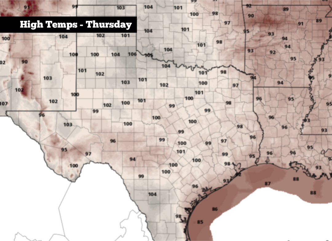
Shown are the expected peak daytime temperatures across Texas on Thursday.
Pivotal Weather
So far this summer, San Antonio has recorded just one 100-degree day, reaching exactly that mark back on July 22. That’s a far cry from a typical summer in San Antonio, which has averaged 27 days of triple-digit heat per year over the past 20 years.

However, San Antonio is likely to increase its total of 100-degree days soon, and it could happen quickly. Several consecutive 100-degree days will be possible as we end July and start August. A a few isolated showers and storms also will be possible over the weekend, as a weak frontal boundary moves into the region. Here’s what you can expect.
Article continues below this ad
Thursday’s forecast
Expect a mild and very muggy start to Thursday in South Texas, as morning temperatures in the upper 70s will be accompanied by mostly cloudy skies. Temperatures will steadily rise as skies become mostly sunny by the middle of the day, likely reaching the 90-degree mark by noon.
Afternoon temperatures are expected to reach near 99 degrees at San Antonio International Airport, the city’s official weather observation site. However, a few spots, especially from downtown and into the South Side, may briefly reach 100 degrees. Elevated humidity levels will result in heat index values of up to 107 degrees.
Article continues below this ad
Shown are the potential humidity-driven heat index values at 4 p.m. Thursday across South Texas.
Pivotal Weather
Temperatures will be very slow to fall during the evening, still likely to be near 95 degrees at 8 p.m. Winds will turn breezy in the evening too, with some gusts as strong as 20 mph. Eventually, overnight lows are likely to fall back into the upper 70s.
More triple-digit heat coming
On Friday, similar weather is anticipated, with partly cloudy skies in the morning transitioning to mostly sunny skies by the afternoon. Temperatures are likely to peak near 100 degrees in San Antonio, while temps are expected to climb to 105 degrees as you push southwest toward Laredo.
Article continues below this ad
Saturday is likely to be the hottest day of the forecast period, ironically because of a weak cold front moving in closer from the north. As the front approaches the region, a meteorological phenomenon known as compressional heating will occur, during which the air ahead of the front will be forced to compress and heat up.
San Antonio temperatures on Saturday are likely to reach 102 degrees during the late afternoon, coming close to the daily record of 103 degrees set in 2013. Humidity-driven heat index values could rise to 109 degrees.
Along the weak front, a few isolated showers and thunderstorms also could form during the late evening and into overnight. San Antonio’s overall rain chances will be at just 20%, so not everyone will see rain.
Article continues below this ad
The front won’t alter temperatures very much from Sunday and into early next week, possibly dropping peak temps by just a couple of degrees. San Antonio is still expected to reach 98 to 100 degrees on Sunday, with more areas likely to reach 100 degrees again on Monday.
On Tuesday, temperatures will once again be close to the 100-degree mark. Then, by the middle and second half of the week, afternoon temps will likely drop slightly back into the upper 90s. A few isolated thunderstorms will also become possible from Wednesday through Friday, but widespread showers appear unlikely.