
This has not been a normal October across Texas. The weather pattern has been stagnant, as high atmospheric pressure over the region has blocked most cold fronts from moving into the state. As a result, Texas is on track to have one of its warmest Octobers on record.
So far this month, San Antonio has reached an average high temp of 92 degrees, which ranks as the city’s second-hottest start to October in weather history. Austin has been even hotter, with an average high of 93.8 degrees thus far.
The heat is not just confined to South-Central Texas – it’s statewide. Houston and Dallas are averaging high temps of at least 90 degrees this month, and both cities are on track to experience an October that would be among top five warmest ever. It’s also the second-hottest start to October in Abilene, and the sixth-hottest out in Lubbock.
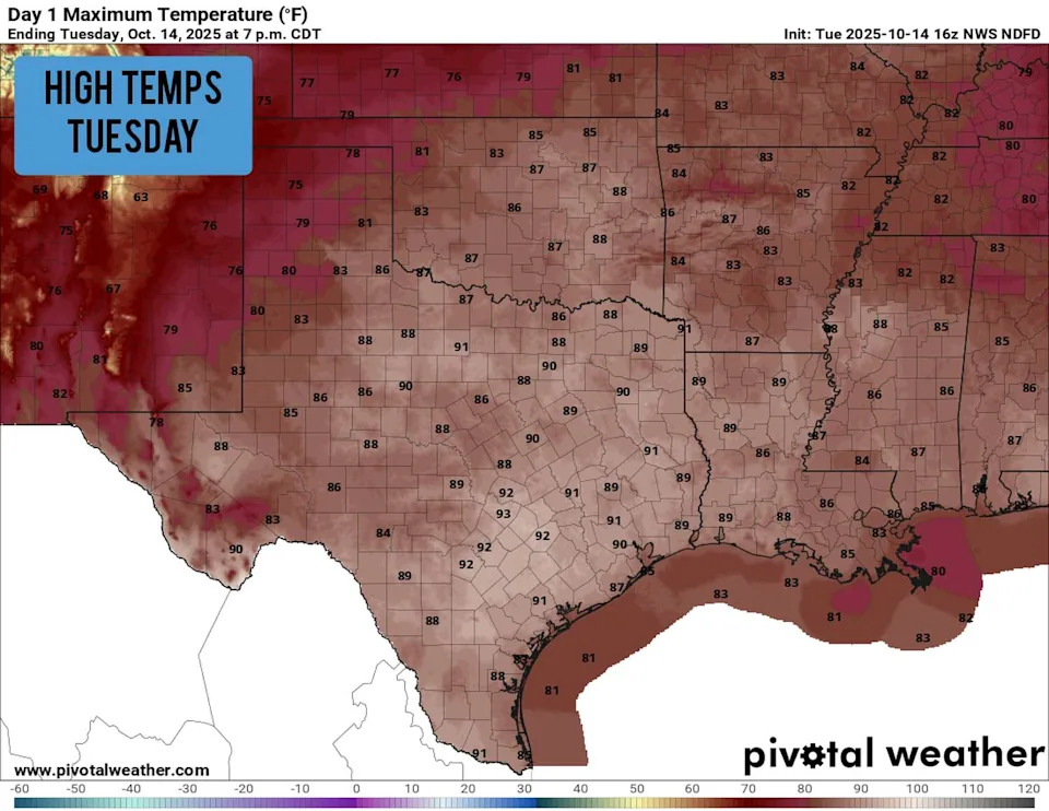
Daily temperatures are expected to rise into the upper 80s to lower 90s across much of Texas on Tuesday. (Pivotal Weather)
With this summer-like heat lingering well into fall, does it mean our first freeze will be delayed? Or will the current warmth have little effect on temperatures a month or two from now? Here’s what we found:
Will the first freeze be delayed?
Going back to 1900, San Antonio’s average date for its first freeze is Nov. 30. But does an unusually warm October actually push that date back?
To find out, we have to take a look back at weather history. We examined the 20 warmest Octobers ever in San Antonio and looked at when the first freeze occurred in each of those years. On average, the first freeze came on Dec. 7 – about a week later than the historical average.
So, while a hot October doesn’t guarantee a late freeze, history suggests that unseasonable warmth this time of year does tend to delay the arrival of freezing temperatures by about a week.
This trend held true for several other Texas cities, too. In Dallas, a warmer October than normal tends to push the first freeze back by about six days, from Nov. 22 to Nov. 28. Houston sees a similar shift, with the average first freeze delayed roughly a week to Dec. 15.
Out in West Texas, Lubbock typically experiences its first freeze much earlier, with the average date coming on Oct. 31. However, history shows that a warmer start to fall delays its first freeze into early November.
Upcoming winter outlook
Not only could Texas experience a delay to its first freeze this year, but the state is also favored to experience slightly fewer freezes overall this winter. That’s because La Niña is active, which generally results in warmer and drier than average winter conditions across the Lone Star State.
La Niña causes a blocking high pressure system to develop over the northern Pacific Ocean, between Hawaii and Alaska. This, in turn, forces the polar jet stream farther north, which reduces the number of strong cold fronts that reach Texas during the winter.
On average, San Antonio records about 14 days each year with temperatures at or below freezing. Closer to the Gulf Coast, Houston averages just 10 such days. Farther north, freezes become much more common: Dallas averages 29 per year, while Amarillo sees an impressive 108 days annually with temperatures of 32 degrees or colder.
This article originally published at First Texas freeze of this winter could be delayed. Here’s when it could arrive..