
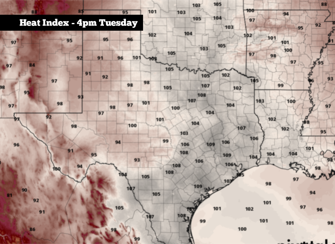
Shown are the expected maximum heat index values across Texas on Tuesday.
Pivotal Weather
South Texas has reached the climatologically hottest part of the year. The good news, however, is that average temperatures will slowly begin to decrease later this month as fall approaches.

From July 30 to Aug. 16, San Antonio’s average high temperature is 97 degrees, the hottest of the year. San Antonio also reaches at least 100 degrees on 45% of calendar days during this period, the highest frequency of any time of the year.
Article continues below this ad
The frequent extreme heat this time of year is largely because of the overall weather pattern. During late July and early August, the upper-level polar jet stream is in its most northerly position of the year, generally stretching across northern Canada, Greenland and toward the North Pole. As a result, significant cold fronts are rare in Texas during this time.
High atmospheric pressure also often builds across Texas during the middle of summer, causing a “heat dome” effect across much of the state. As air sinks under the high pressure, it compresses and warms, raising temperatures at the surface. The high air pressure also acts like a lid, preventing hot air from rising, cooling or dissipating.
When will temps start to cool?
Average high temperatures will start to fall slowly during the second half of August. On Aug. 17, San Antonio’s average high temp drops to 96 degrees. Then by Aug. 23, the average dips by another degree to 95.
Article continues below this ad
While subtle at first, the cooling temperatures will become more noticeable as we move into the fall. By Sept. 15, San Antonio’s average high temperature is 90 degrees, further cooling into the lower 80s by the middle of October.
However, even as average temperatures decrease, triple-digit heat can still occur from late August and even into September. From Aug. 20-31, San Antonio reaches at least 100 degrees on 34% of calendar days. By September, that frequency drops to just 5%.
What causes the change?
First of all, the polar jet stream typically begins to slowly shift southward during late August and into September. While strong cold fronts are still not common in Texas during this time, this gradual shift results in a slightly more active weather pattern and cooler temperatures.
Article continues below this ad
The angle of the sun also becomes lower in the horizon during the second half of August. A lower sun angle means the ground receives less direct solar energy, which correlates to lower average temperatures.
This NOAA diagram shows the positions of the subtropical and polar jet streams. During the summer, the polar jet stream shifts to the north, closer to the north pole.
NOAA
The process also causes the days to become shorter. During August, San Antonio will lose 45 minutes of daylight before losing another 50 minutes of daylight during September.
When will the first strong cold front arrive?
During late August and September, weak cold fronts start to become more common across the Lone Star State. However, these fronts generally only bring small changes in temperatures, sometimes by as little as 5 degrees or less.
Article continues below this ad
On average, San Antonio’s first strong cold front of the year — when peak daytime temperatures drop by at least 15 degrees from one day to the next — occurs in mid-October. That lines up closely with the city’s average first instance of overnight temps at 50 degrees or colder in the second half of the year, which happens Oct. 16.
So while San Antonio is currently stuck in the hottest part of the year, the good news is that cooler weather is not too far away.