
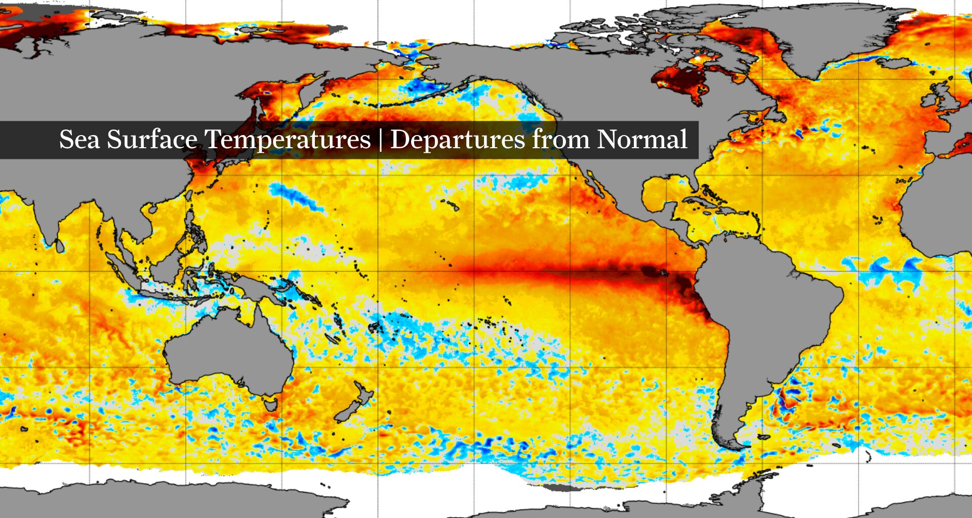
NOAA’s Coral Reef Watch monitors global sea-surface temperature anomalies. As of Tuesday, it showed widespread above-average ocean temperatures across much of the world’s oceans, including a pronounced band of unusually warm water stretching across the central and eastern equatorial Pacific — a hallmark of the ongoing El Niño. Cooler waters (shown in blue) are scattered across parts of the western Pacific and Southern Ocean.
NOAA’s Coral Reef Watch
Houston has reached 100 degrees only once so far in 2026 after recently enduring back-to-back summers with prolonged heat waves in 2022 and 2023. The main difference this year has been the emergence of what is shaping up to be a “super El Niño.” So, is the strengthening El Niño helping Southeast Texas avoid triple-digit heat?
History suggests it may improve the odds, but the answer isn’t nearly as clear-cut as it is for hurricanes. While many El Niño summers have produced few or no 100-degree days in Houston, others have featured prolonged periods of extreme heat. And because El Niño summers are relatively uncommon, there simply isn’t a large enough sample to draw firm statistical conclusions.
To better understand the relationship, we looked at weather records from every meteorological summer (the calendar months of June, July and August) since 1950 when El Niño was present. We then compared them to Houston’s weather averages from 1991-2020, which are the climate benchmarks the National Weather Service currently uses as 30-year “normal” values.
Article continues below this ad
Does El Niño mean fewer 100-degree days in Houston?
Will El Niño, the cyclical cooling of sea-surface temperatures in the tropical waters of the eastern Pacific Ocean, lead to fewer 100-degree days in Houston? Sometimes.
Houston averages about 6.3 days at or above 100 degrees during meteorological summer, based on the 1991-2020 climate period.
The historical record during El Niño events reveals a mixed picture.
Article continues below this ad
Of the 17 El Niño summers examined, eight never reached 100 degrees at all. Another seven recorded just one or two triple-digit days — fewer than Houston experiences during a typical summer.
‘DOG DAYS’ EXPLAINED: What are the dog days of summer? 5 things every Texan should know.
Taken together, those summers suggest El Niño may improve the odds of avoiding prolonged stretches of extreme heat.
But history also shows El Niño doesn’t guarantee relief.
Article continues below this ad
The two biggest exceptions came in 2015 and 2023. The moderate El Niño summer of 2015 produced 10 days at or above 100 degrees in Houston. Even more striking was 2023, when Bush Intercontinental Airport reached the century mark on 38 days during meteorological summer despite El Niño already being established. By the time cooler fall weather arrived, that total had climbed to 45 — just one day shy of the record set in 2011.
That summer stands apart from the rest of the El Niño record, illustrating how a single outlier can shape conclusions drawn from such a limited sample.
Those exceptions highlight an important point: El Niño influences the atmosphere, but it isn’t the only factor determining how hot Houston becomes.
What history says about El Niño and Houston heat
Unlike hurricanes, where El Niño’s influence is well established, summer temperatures depend on a much broader collection of weather patterns.
Article continues below this ad
Persistent upper-level ridging of high air pressure over Texas, along with soil moisture, rainfall, cloud cover and day-to-day weather patterns, all influence whether temperatures repeatedly climb into the triple digits. El Niño can affect those ingredients, but it doesn’t control them.
This NOAA diagram shows how high atmospheric pressure — known as a heat dome — can act as a cap, allowing heat to build at the Earth’s surface. Persistent heat domes are responsible for bringing Houston some of its hottest and driest days of summer.
NOAA
That helps explain why Houston’s El Niño summers have varied so dramatically.
Some El Niño summers were cooler than the city’s modern climate normals, while others were warmer. Seasonal rainfall totals also ranged from just over 6 inches to more than 21 inches, underscoring how much variability exists from one El Niño summer to the next.
The relatively small sample size adds another layer of uncertainty.
Article continues below this ad
CLIMATE CONNECTIONS: What would a stronger El Niño mean for Texas hurricane season or the chances of a Houston snowfall?
Modern El Niño records date to 1950, leaving only 17 meteorological summers when El Niño was present during June, July and August. That’s enough to identify recurring patterns, but not enough to say El Niño alone determines how hot a Houston summer will become.
Can Houston still reach 100 degrees during El Niño?
History shows El Niño can coincide with summers featuring little or no triple-digit heat, but it also shows prolonged heat waves remain possible.
That’s why meteorologists often describe El Niño as changing the odds rather than determining the outcome.
So far this year, Houston has reached 100 degrees only once — well below what residents experienced during the back-to-back sizzling summers of 2022 and 2023.
Whether that remains the case through the rest of the summer will depend on more than what’s happening in the tropical Pacific.
A persistent ridge of high pressure developing over Texas could quickly erase the season’s relatively modest start. Conversely, continued rainfall and periodic disturbances could keep temperatures closer to seasonal averages.
In other words, El Niño may be one reason Houston has largely avoided prolonged triple-digit heat so far this summer. But history suggests it changes the odds — not the outcome.