
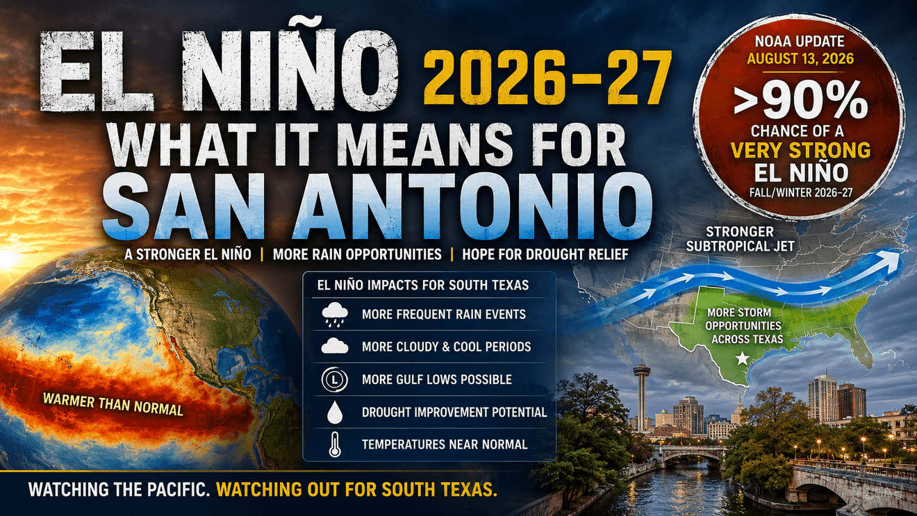
SAN ANTONIO – The El Niño developing across the tropical Pacific has moved well beyond the point of whether it will simply become strong.
NOAA’s Climate Prediction Center said that there is now a greater than 90% chance of a very strong El Niño during the fall and winter of 2026–27. There is a 69% probability that the October-through-December peak could reach a magnitude greater than any previous El Niño in the record dating to 1950.
Now, that does not mean South Texas is guaranteed an exceptionally wet, cold or stormy winter. It does significantly increase the odds that El Niño will play a major role in our weather over the next several months. This is significant, for a region that has spent years dealing with drought and water-supply concerns.
El Niño Is Strengthening Dramatically
During July, one of the primary areas meteorologists monitor for El Niño — averaged about 1.4 degrees Celsius warmer than normal. Farther east, temperatures reached 2 degrees or more, while some subsurface areas of the Pacific were running as much as 10 degrees Celsius above normal.
The atmosphere has taken note and is now reacting to that warm water.
Wind patterns, tropical rainfall and atmospheric pressure across the equatorial Pacific are all showing the signs of a strengthening El Niño. So, what’s ahead for the region?
There is a 93% chance of a very strong El Niño.September through November. That increases to 95% for October through December and remains 90% for November through January. Even December through February carries a 70% probability of the highest strength category in NOAA’s current outlook.
That is an unusually strong signal this far ahead of winter.
Why Should We Care in San Antonio?
Because El Niño can rearrange the winter storm track across North America. During many El Niño winters, the subtropical jet stream becomes stronger and more active across Mexico and the southern United States. Think of it as opening a multi-lane highway for Pacific weather disturbances.
Instead of storms routinely passing well north of Texas, more upper-level systems can move across northern Mexico, Texas and the Gulf Coast.
For South Texas, that can mean more opportunities for widespread rain, more cloudy days and the opportunity for development of organized storm systems near the Texas coast or western Gulf. The important word is opportunity.
A wetter winter does not necessarily mean constant rain. It means there may simply be more chances for meaningful rain-producing weather systems than we would normally see. Several well-placed winter rain events could make a significant impact.
Could El Niño Help the Drought?
Potentially — and this could become the biggest South Texas story of the winter. El Niño does not create rain equally everywhere. Where the rain falls can be just as important as how much falls. Rain over downtown San Antonio is useful.
Rain over the recharge zone and watersheds feeding rivers, reservoirs and the Edwards Aquifer can be far more important hydrologically. A sustained series of winter storm systems could gradually improve soil moisture and streamflow and potentially provide meaningful recharge.
But there is an important distinction.
El Niño increases the odds of a wetter pattern. It does not guarantee enough rain will fall in exactly the right places to erase a multi-year drought.
Will It Be a Cold Winter?
Not necessarily. This is probably the biggest misconception surrounding El Niño in Texas.
El Niño winters can produce numerous chilly, damp and cloudy stretches across South Texas without the entire winter being unusually cold. NOAA’s current December-through-February outlook favors near-normal temperatures across portions of the southern United States rather than a broad colder-than-normal winter.
Think several days with temperatures in the 40s and 50s under clouds and drizzle, followed by stretches in the 60s and 70s. The winter can feel cold at times while the seasonal average ultimately ends up fairly close to normal.
So the better description at this point may be: More opportunities for cool, cloudy and wet weather — not necessarily an unusually cold winter overall.
What About a Major Freeze?
That question can’t be answered right now. It’s just too early to tell. While we have some incredible forecast tools, they aren’t good enough to reliably predict several months ahead.
El Niño alone does not tell us whether Arctic air will reach Texas. Major freezes depend on much shorter-term atmospheric patterns involving the jet stream, Arctic Oscillation, North Atlantic Oscillation, high-latitude blocking and the behavior of the polar vortex.
El Niño can, however, create one ingredient that becomes important if Arctic air does arrive: an active southern storm track carrying moisture across Texas.
That combination — cold air already in place with a disturbance moving overhead — is how the possibility of freezing rain, sleet or snow can occasionally develop.
But at this point, predicting a major Texas winter storm would be pure guesswork.
Could This Become Another 1997–98?
That comparison is going to receive plenty of attention if El Niño continues strengthening.
The 1982–83, 1997–98 and 2015–16 El Niño events are among the strongest modern events and are natural benchmarks for what is developing now. But no two El Niños behave exactly alike. The exact location of the warmest Pacific water matters. So does the atmospheric response, the pattern of the North Pacific, other tropical patterns and shorter-term changes in the jet stream.
El Niño strength does not automatically determine the strength of its impacts. Stronger events generally increase confidence in some typical El Niño patterns, but they do not guarantee them.
That makes 1997–98 a useful comparison — but not a forecast template.
One Number Really Stands Out
There is another statistic in NOAA’s update that deserves attention.
This El Niño has a 69% chance of reaching a three-month Relative Oceanic Niño Index of at least +2.5C during October through December.
Reaching that level would make it stronger than any the of previous El Niño events in its historical record dating to 1950.
What We Should Expect in South Texas
At this stage, the most reasonable Winter 2026–27 outlook for San Antonio and South-Central Texas is becoming clearer.
A stronger southern storm track is increasingly likely. That means more opportunities for rain, including the possibility of several widespread winter rainfall events.
We should also expect an increased chance of extended cloudy and cool periods, especially when upper-level disturbances move across northern Mexico and Texas.
There may be more opportunities for Gulf low-pressure systems, which can produce widespread rain and occasionally thunderstorms.
Average winter temperatures may ultimately remain fairly close to normal even if we experience numerous chilly periods.
Most importantly, the developing pattern gives South Texas a better opportunity for drought improvement than we’ve seen heading into several recent winters.
The Bottom Line
El Niño is not a guarantee.
It cannot tell us today whether San Antonio will experience a freeze in January, an ice storm in February or exactly how much rain will fall over the Edwards Aquifer recharge zone.
For now, the Pacific is sending an increasingly strong signal our way.
Winter 2026–27 has the potential to be one of the more consequential South Texas winters we’ve watched in quite some time — particularly when it comes to rainfall and drought recovery.