
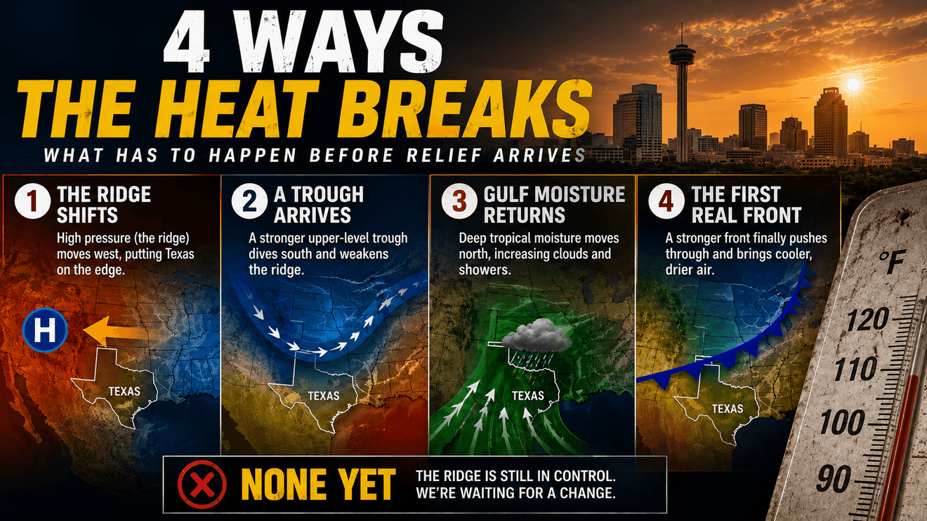
SAN ANTONIO – The thermometer keeps reaching 100 degrees. Rain remains but a distant memory and every extended forecast seems to offer more of the same. So what actually has to happen in the atmosphere before South Texas finally gets a break from the heat?
Right now, South-Central Texas is trapped beneath a stubborn summertime weather pattern dominated by high pressure high in the atmosphere. The pattern will send temperatures and heat index numbers into triple digits over the next several days, with a Heat Advisory in effect through Sunday for the northern Hill Country, I-35 Corridor and Coastal Plains.
Highs could reach 105 degrees in some locations. Heat indices could reach 113. An Extreme Heat Warning may be needed this weekend.
But here’s the important part: A heat wave doesn’t end because it has lasted a long time. Something has to change in the atmosphere and there are several ways that can happen.
First, understand what’s holding the heat in place
Several miles above Texas is a large area of high atmospheric pressure — an upper-level ridge. Underneath that ridge, air tends to sink. Sinking air warms as it compresses. It also squeezes out the development of widespread clouds and thunderstorms. That leaves us with plenty of sunshine, limited rainfall and afternoon heating day after day after day.
The Climate Prediction Center’s latest extended outlook shows that ridge remains a major player. Forecast models agree on a strong mid-level ridge centered over the Great Plains during the August 25–29 period.
So if you’re searching the forecast for the cold front that’s going to suddenly knock 15 degrees off the temperature in the days ahead, that’s not what the atmosphere is showing us. Something first has to disrupt the ridge.
BREAK SCENARIO #1: The ridge moves
This is probably the simplest way out. The center of high pressure doesn’t necessarily have to disappear. It just needs to move. Imagine standing directly underneath an umbrella. As long as the umbrella remains centered over you, you’re protected from the rain. Move the umbrella several feet away and suddenly you’re exposed.
An upper-level ridge works differently, of course, but it’s kinda the same principle. If the center of the ridge shifts west toward New Mexico, Arizona or the Desert Southwest, South Texas could move closer to its eastern edge.
That matters because disturbances can travel around the perimeter of high pressure.
Moisture can increase. Thunderstorm chances can increase. Cloud cover can increase and temperatures can begin coming down.
That’s one of the first things I’ll be watching for in the models: Where is the center of the ridge? Not simply whether high pressure still exists.
BREAK SCENARIO #2: A trough punches into the ridge
Another possibility comes from farther north. A stronger upper-level disturbance — what meteorologists call a trough — could move across the United States and begin flattening the ridge.
Think of the ridge as a big atmospheric hill. A sufficiently strong weather system moving across the country can knock down part of that hill. Once that happens, the upper-level flow becomes more progressive. Weather systems start moving again.
A surface front could push farther south. Rain chances could increase. Temperatures could fall.
But there’s a problem in August. Cold fronts don’t particularly enjoy visiting South Texas this time of year. The temperature contrast that drives stronger fronts during fall and winter is much weaker.
A front can push into North Texas and stall. Or reach Central Texas and wash out. So simply seeing a front somewhere on a model map isn’t enough. For meaningful relief in San Antonio, we need to see whether the upper-level pattern can actually push that boundary this far south.
BREAK SCENARIO #3: Gulf moisture fights back
We don’t necessarily need a cold front to lower temperatures. Rain can do it too.
If deeper tropical moisture moves into South Texas, several things can happen. Cloud cover increases. That reduces incoming solar energy. Showers and thunderstorms develop. Rain-cooled air spreads outward from storms.
Wet ground changes how some of the following day’s solar energy is used. Instead of almost all that energy heating dry ground and the atmosphere above it, more can go toward evaporation.
One rainy day doesn’t necessarily end a heat wave. But several days with greater cloud cover and scattered rainfall can begin weakening the feedback that keeps hot, dry weather going.
The difficulty right now is that persistent high pressure is suppressing exactly the widespread rainfall we would need.
BREAK SCENARIO #4: The tropics change the pattern
This one becomes increasingly interesting as we move deeper into August. Tropical moisture can sometimes move north from the Caribbean or Gulf of Mexico.
It doesn’t require a hurricane. A tropical wave, broad disturbance or simply a surge of deep moisture can dramatically change the amount of water available in the atmosphere.
Put that moisture underneath a weakening ridge and rain chances can increase quickly.
There’s an irony here. The same time of year when South Texas desperately wants relief from summer heat is also when the Atlantic hurricane season is becoming increasingly active.
So tropical moisture can be beneficial. A tropical cyclone obviously can be anything but.
The important distinction is whether we get moisture without a significant tropical threat. That’s something we’ll increasingly watch as August turns into September.
And then there’s the calendar
Eventually, another mechanism begins working in our favor. The sun.
We’re already well past the summer solstice. The length of daylight is gradually decreasing. The sun’s maximum angle above the horizon is slowly lowering. Nighttime becomes longer.
That doesn’t suddenly make September cool in San Antonio. Far from it. September can produce brutal heat.
But the amount of solar energy available to maintain extreme summertime temperatures is gradually declining. The atmosphere eventually starts fighting a losing battle against the calendar.
Then stronger cold fronts begin appearing farther north. The jet stream becomes more active. And eventually one of those fronts makes it all the way to South Texas.
That’s the transition we’re waiting for. We’re just not there yet.
What would tell us the pattern is actually changing? This is where we can separate real relief from wishful thinking. There are several signals worth watching: The 500-millibar ridge shifts away from Texas. That’s one of the biggest clues. Atmospheric heights begin falling over the Southern Plains. That tells us the column of exceptionally warm air is weakening. Ensemble models agree on the change.
One model run showing a cold front ten days away isn’t enough. We want multiple models and multiple ensemble members showing the same evolution over successive runs. Rain chances increase for several consecutive days. Not 10 percent on one afternoon. A genuine increase in atmospheric moisture and instability.
Forecast highs begin falling consistently. 102 → 101 → 99 isn’t necessarily a pattern break. But 102 → 98 → 94 accompanied by increasing clouds, rain chances or a wind shift would get our attention.
And perhaps most importantly: Overnight lows start dropping. That’s when the atmosphere finally begins giving us meaningful recovery.
What we’re seeing right now
Unfortunately, the extended pattern doesn’t yet provide a strong signal that the heat is about to collapse.
The Climate Prediction Center’s August 19 outlook keeps the amplified ridge centered over the Great Plains through late August. Its hazards outlook also identifies the potential for a significant and long-duration extreme heat event across the southern United States, focused from the Desert Southwest into the Great Plains beneath a potent mid-level high.
That’s not the atmospheric setup you want to see if you’re hoping for an early end to summer.
It doesn’t mean every day will be identical. The ridge can wobble. Moisture can fluctuate. An isolated thunderstorm can temporarily cool one neighborhood while another remains dry.
But those are interruptions. We’re looking for a pattern change. And that’s a much higher bar.
The Bottom Line
There isn’t a date on the calendar when South Texas heat simply switches off. The atmosphere has to earn its way out of this pattern. The ridge needs to move or weaken.
A stronger trough could push south. Deeper Gulf moisture could return. Rainfall could interrupt the hot-and-dry feedback.
Eventually, increasingly strong late-summer and early-fall weather systems will begin helping us.
But until one or more of those things happens, the basic forecast remains stubbornly familiar: Hot. Mostly dry. And hotter than most of us would like.
So instead of asking “When does the heat end?”, there’s a better question to watch over the next couple of weeks: “Has anything changed in the atmosphere that can actually end it?”
Right now, the answer is: Not yet.