
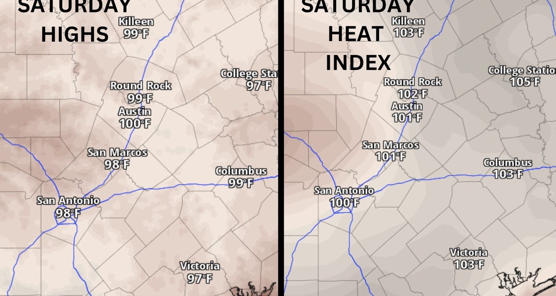
Saturday temperatures in Central Texas won’t be nearly as hot as earlier this week.
Pivotal
Saturday’s weather will be sunny and hot, with calm south-southeast winds. Afternoon temperatures will range from 98 to 100 degrees along the Interstate 35 corridor. Humidity will dip in the afternoon, so the heat will “feel” only a degree or two warmer than the actual temperatures.

What can we expect this weekend?
After an eventful couple of days in Central Texas, we’re settling into a quiet and calm weekend across the region.
Article continues below this ad
Expect more heat, but nothing excessive like earlier in the week. Sunday will be much like Saturday, with mostly sunny skies, temperatures near 100 degrees. With less humidity, heat index values will be more subdued, climbing to only 101 to 102 degrees. Dare we say, it may be comfortable for the last weekend of August?
We’ve already reached our yearly average number of days with triple-digit temperatures, and we’ll likely add a few more this weekend and into early September before temperatures begin to ease a bit later in the month.
How much rain did we get this week?
After finally getting some rain Thursday in the gauges at Camp Mabry, Austin’s main weather observation site, August 2026 is no longer in the running for Austin’s driest August on record.
Article continues below this ad
Austin broke its 34-day streak of rain-free weather Thursday and logged 0.34 inch of rainfall at Camp Mabry, but only 0.07 inch at Austin-Bergstrom International Airport. Other rainfall totals that day included:
0.89 inch on Barton Creek at Oak Hill
0.88 inch in Manchaca
0.61 inch in Dripping Springs
0.51 inch in Blanco
0.46 inch in Jollyville
0.42 inch in Cedar Park
0.4 inch on Lake Austin at Cortana Shores
Will we get another shot at rain?
The summer heat dome caused by a strong ridge of high air pressure will take another trip across the southern Plains over the weekend before parking itself over the southeastern United States by Monday.
Article continues below this ad
This will once again open the door to increased rain activity as clockwise winds, or anticyclonic flow, around the system of high pressure steer atmospheric disturbances into the Lone Star State.
This weather setup is known as a “ring of fire,” and Texas will be in its path for a few days with some rain chances ramping up Monday through Wednesday.
Rainfall totals through next Friday will likely be highest in Southeast Texas, east of the Interstate 35 corridor.
Pivotal
What’s the forecast for September?
September arrives Tuesday, marking the start of meteorological fall, which is simply the calendar months of September, October and November. Meteorologists and climate scientists prefer to track the season using fixed calendar months instead of the fall and winter equinoxes because the dates of each equinox can vary over time.
Article continues below this ad
While meteorological fall begins Sept. 1, astronomical fall arrives later in the month, when Earth’s northern and southern hemispheres get equal amounts of sunlight, marking the autumnal equinox. This year, the equinox occurs at 7:05 p.m. on Sept. 22 in Austin.
September is an important transition month for Central Texas. We typically start the month still feeling the heat of summer, with afternoon highs in the 90s and morning lows in the low 70s. By the end of the month, however, we can begin to see hints of fall, with average highs dropping into the 80s and morning lows dipping into the 60s.
The Climate Prediction Center’s outlook calls for a slightly warmer September than normal, but the month also could bring near-average or above-average rainfall.
Article continues below this ad
Weekend forecast by region
Hill Country (Fredericksburg, Blanco, Llano and Burnet): Expect mostly sunny skies with peak daytime temperatures ranging between 95 and 99 degrees. Higher elevations typically mean cooler temperatures, so some Hill Country communities will avoid triple-digit heat.
Interstate 35 corridor (Round Rock, Austin, San Marcos): Look for sunny skies. Afternoon temperatures in the urban heat islands along I-35 will rise to as high as 101 degrees.
Coastal Plains (Bastrop. Smithville, Lockhart): Plan for plenty of sunshine with above-normal heat Friday east of the I-35 corridor. Daytime high temperatures will range from 100 to 101 degrees.