
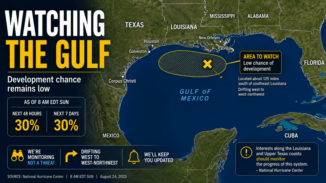
Something we’re watching in the northern Gulf has become a little more interesting this morning.
Not alarming. But more interesting.
The National Hurricane Center is monitoring AL97, an area of low pressure now located about 125 miles south of the southeastern Louisiana coast. Showers and thunderstorms associated with the low have become more concentrated, and NHC says some slow tropical development is possible during the next couple of days. That possibility of tropical development has increased to:
30% during the next 48 hours
30% during the next seven days
That’s a meaningful change from Saturday, when the seven-day probability was 20% and the short-term probability was near zero.
What’s actually out there?
AL97 is not a tropical depression or tropical storm.
NHC says surface observations this morning show that the system has not strengthened, despite the increased concentration of showers and thunderstorms.
So, the better description is an area of low pressure with increasingly concentrated thunderstorm activity. I will be watching today to see whether the thunderstorms remain organized long enough for the surface circulation to become better defined.
Where is it?
AL97 is in the northern Gulf, south of southeastern Louisiana. NHC expects the disturbance to drift westward to west-northwestward across the northern Gulf during the next couple of days. That westward component is why this deserves attention in Texas.
In fact, NHC now specifically says:
“Interests along the Louisiana and Upper Texas coasts should monitor the progress of this system.”
That’s considerably more useful than simply saying there’s “something in the Gulf.”
Does this mean Texas is threatened?
Not at this point.
There is no tropical cyclone, no NHC forecast cone and no tropical watches or warnings associated with AL97. A 30% development probability still means development is not the most likely outcome during the period.
But there’s an important difference between no threat and nothing to watch.
We’re now dealing with a disturbance already inside the Gulf, moving generally westward during the heart of hurricane season. That combination deserves monitoring even while development probabilities remain relatively low.
What about South Texas?
For San Antonio and South-Central Texas, the immediate weather story remains heat, not AL97.
My forecast calls for hot and mostly dry conditions, with temperatures generally in the mid and upper 90s to around 103 degrees through the coming week.
I am expecting to see some seabreeze showers and thunderstorms early this week, particularly across the Coastal Plains.
There’s another tropical feature to watch
AL97 isn’t alone on the Atlantic map.
The remnants of Tropical Storm Dolly are moving rapidly west to west-northwest at about 25 mph through the northeastern Caribbean. NHC says redevelopment is unlikely during the next day or two, but conditions could become more favorable by the middle of the week when the system reaches the southeastern Gulf.
Its probabilities are currently near 0% through 48 hours and 20% through seven days.
So by midweek we could potentially be watching two separate tropical features associated with the Gulf, although neither is currently a developed tropical cyclone.
That’s worth keeping an eye on.
What we’re watching next
For AL97, three things matter today: whether a better-defined surface circulation develops, whether thunderstorms continue becoming more concentrated, and exactly how the westward/west-northwestward movement evolves.
The next NHC outlook will tell us whether today’s jump to 30% was the beginning of a trend or simply recognition of a temporarily better-organized disturbance.
Bottom line
AL97 has our attention — but it isn’t time for alarm.
Development chances have increased. The system is now south of Louisiana. It’s moving generally toward the west. And NHC specifically says people along the Louisiana and Upper Texas coasts should monitor it.
For San Antonio and South-Central Texas, there is no indication that preparations are necessary because of AL97.
But this is exactly the kind of Gulf disturbance we watch carefully.
Because in late August, when something is already sitting in the Gulf, distance becomes part of the forecast.