
FORECAST HIGHLIGHTS
RED FLAG WARNING: High fire danger until 9 pm Sunday
THIS MORNING: Gusts up to 40-45 mph
THIS AFTERNOON: Still breezy, but less wind. Near 70°
MONDAY MORNING: 30s. Light freeze in Hill Country possible
VETERANS DAY: Cold start. Pleasant afternoon
REST OF WEEK: Warming back into the 80s
FORECAST
A cold front has swept through San Antonio and South Central Texas. While this will eventually bring our chilliest weather since February, the immediate concern is for wildfire risk due to very gusty winds.
SUNDAY
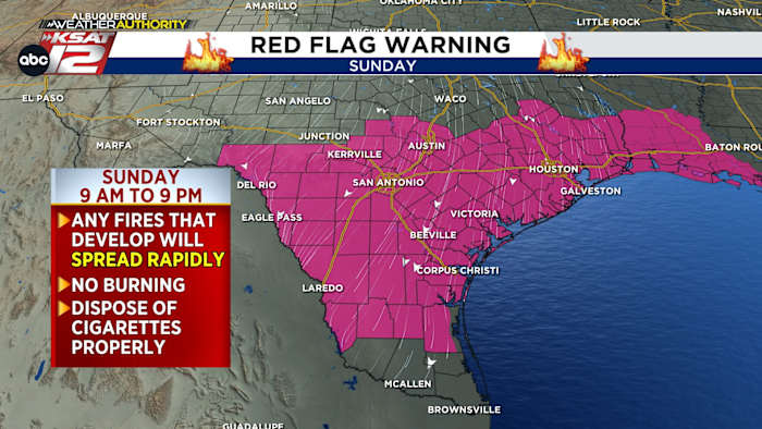
Wind gusts will be strongest in the morning today, potentially gusting up to 40-45 mph. Very dry air is moving in. This combo means that any fires that develop could easily spread. A RED FLAG WARNING is in effect until 9 pm for most of South Central Texas, including the San Antonio metro area.
Sunday’s Forecast (Copyright 2025 by KSAT – All rights reserved.)
By the afternoon, it’ll still be breezy with gusts up to 30 mph, but not nearly as windy as the morning. Highs will be much cooler than yesterday – in the upper-60s.
Tonight, winds will calm and temperatures will plummet.
MONDAY
A light freeze is possible in the Hill Country Monday morning. Staying above freezing in San Antonio (Copyright 2025 by KSAT – All rights reserved.)
While temperatures are expected to be cold but above freezing for San Antonio, a light freeze is possible in the Hill Country.
Under complete sunshine, we’ll only warm to near 60°.
VETERANS DAY (TUESDAY)
Another cold start. But it will be very pleasant, quickly warming, with a high near 70°.
REST OF THE WEEK
We’ll gradually warm each day with highs firmly back in the 80s by Thursday.
The latest 7 day forecast from Your Weather Authority (Copyright 2025 by KSAT – All rights reserved.)Daily Forecast
KSAT meteorologists keep you on top of the ever-changing South Texas weather.
WEATHER LINKS
Copyright 2025 by KSAT – All rights reserved.