
Low rain chances Thursday & Friday
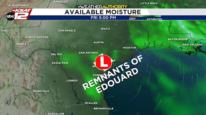
The remnants of Edouard may bring a few showers Thursday and Friday (Copyright KSAT-12 2026 – All Rights Reserved)FORECAST HIGHLIGHTS
REMNANTS OF EDOUARD: Leftover moisture will bring a few isolated downpours Thu/Fri
HOT LABOR DAY WEEKEND: Upper-90s, humidity
NO FRONT IN SIGHT: Hot through mid-September
FORECAST
TODAY
Wednesday will be hot & quiet. That said, like Tuesday, a few showers could affect those areas east of San Antonio. Highs will reach the upper-90s this afternoon.
THURSDAY/FRIDAY RAIN CHANCE
Meantime Edouard will continue to weaken as it moves north toward Dallas today. By Thursday and Friday, the remnants of Edouard will get pulled southwest toward San Antonio. With some leftover moisture, isolated to widely scattered showers are possible Thursday and Friday. Rainfall totals should generally be light, but a few heavier downpours can’t be ruled out.
Future radar for Thursday (9/3) at 5pm (Copyright KSAT-12 2026 – All Rights Reserved)
HOT LABOR DAY WEEKEND
Any rain chance will end by Saturday, leaving us hot and dry for the Labor Day weekend. Highs will remain in the upper-90s. Temperatures are showing few signs of relenting, meaning above-average temps will continue into mid-September.
Extended Forecast (Copyright KSAT-12 2026 – All Rights Reserved)Daily Forecast
KSAT meteorologists keep you on top of the ever-changing South Texas weather.
QUICK WEATHER LINKS
Copyright 2026 by KSAT – All rights reserved.
About the AuthorJustin Horne headshotJustin Horne
Justin Horne is a meteorologist and reporter for KSAT 12 News. When severe weather rolls through, Justin will hop in the KSAT 12 Storm Chaser to safely bring you the latest weather conditions from across South Texas. On top of delivering an accurate forecast, Justin often reports on one of his favorite topics: Texas history.