
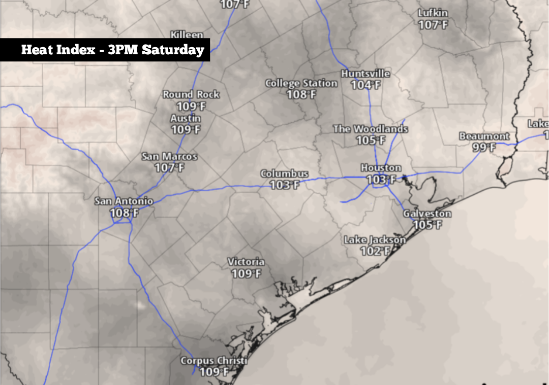
Shown are the expected heat index values across the region at 3 p.m. Saturday afternoon. A heat advisory is in place through 7 p.m.
Pivotal Weather
The calendar may say that it’s the middle of September, but mid-summer heat is still hanging around across South-Central Texas. According to San Antonio’s climate data, average high temperatures for Sept. 12 should be in the low 90s. However, Saturday temps will instead be about 10 degrees above normal.

The incoming heat has prompted the National Weather Service to issue a heat advisory for San Antonio, as well as across the Interstate 35 corridor from New Braunfels to Austin. Triple-digit heat is expected throughout this region, and San Antonio could even challenge a temperature record that has stood since the late 19th century. Here’s a close look at what to expect.
Article continues below this ad
Saturday’s forecast
Early morning conditions will be mild yet comfortable as San Antonio temps will hover in the upper 70s through 8 a.m. Skies will become mostly sunny by the late morning hours, resulting in fast-rising temperatures. San Antonio will be at the 90-degree mark just after 11 a.m., with heat index values already nearing 100 degrees.
By 3 p.m. to 4 p.m., high temperatures in the Alamo City are expected to reach 101 to 102 degrees. These temperatures will challenge, but likely come just short of the daily record of 103 degrees. That record was set an incredible 133 years ago — on Sept, 12, 1893 — back when San Antonio had an estimated population of just over 40,000 residents.
Article continues below this ad
With high humidity levels still expected throughout the afternoon, heat index values will likely max out between 106 and 108 degrees. Due to these extreme temperatures, a heat advisory will be active between noon and 7 p.m.
“Drink plenty of fluids, stay in an air-conditioned room, stay out of the sun, and check up on relatives and neighbors,” the National Weather Service said in a statement.
Additionally, a few isolated showers and storms may develop across the Hill Country and Interstate-35 corridor during the late afternoon and evening. Overall rain chances in San Antonio will be at 10% to 20%.
A heat advisory has been issued for the highlighted area until 7 p.m. Saturday. Heat index values up to 108 degrees are possible.
NWS Austin/San Antonio
Temperatures will be slow to fall during the evening. By 8 p.m., San Antonio will still likely be in the mid-90s. Temperatures likely won’t fall back into the upper 80s until after 9 p.m. Evening winds will also increase, with some gusts over 20 mph expected between 7 p.m. and 10 p.m.
Article continues below this ad
Temperatures slowly fall
Following the intense Saturday heat, South Texas temperatures will fall just slightly on Sunday as highs will likely reach 99 to 100 degrees. Heat index values up to 106 degrees will also remain likely.
An isolated shower or weak storm will be possible by late Sunday afternoon or evening. However, rainfall coverage will be very low, with only about a 10% chance of rain throughout the San Antonio metro area.
Similar weather is expected from Monday through Wednesday, as high temperatures consistently reach the upper 90s to near 100 degrees. Low temperatures will also stay consistently warm, falling only into the upper 70s each morning.
Article continues below this ad
Finally, weather models show more significant changes as part of the long-range forecast. San Antonio high temperatures are likely to drop to around 96 to 97 degrees by Friday, potentially falling a few degrees lower by the weekend as a potential cold front moves into parts of Texas.
It’s too early to tell exactly how much the potential front could affect San Antonio, but the more active weather should at least bring chances for scattered showers and thunderstorms.