
It’s been a blistering start to September across South Texas. Through Sept. 12, San Antonio’s average high temperature during the month has been 98.2 degrees — tied for the fourth-hottest start to September in the city’s history.
In addition, San Antonio has already endured five days this month with 100-degree temperatures, far more than average.
With high-pressure hovering over the southern U.S., this abnormal late summer heat is expected to continue Sunday and into much of the upcoming work week. However, weather models are showing signs that a slight shift in the pattern is expected by the end of the week and into next weekend, which could result in lower temperatures.
A mild and humid start is expected in San Antonio on Sunday as temperatures will sit in the upper 70s through 8:30 a.m. under partly cloudy skies. More sunshine is expected by late morning, allowing temperatures to rise quickly to 90 degrees before noon.
Temperatures will keep rising through the afternoon, likely reaching a high temperature at 99 to 100 degrees by 4 p.m. Brutal humidity will also stick around, causing heat index values to reach 105 to 107 degrees. If you’re spending time outdoors, be sure to stay hydrated and take frequent breaks in air-conditioned spaces.
A few isolated showers and storms may also form during the late afternoon and evening, particularly between 4 p.m. and 8 p.m. Not everyone will see rain, though, as overall storm coverage will only be near 20% in the San Antonio metro area. Isolated brief downpours and gusty winds will be possible.
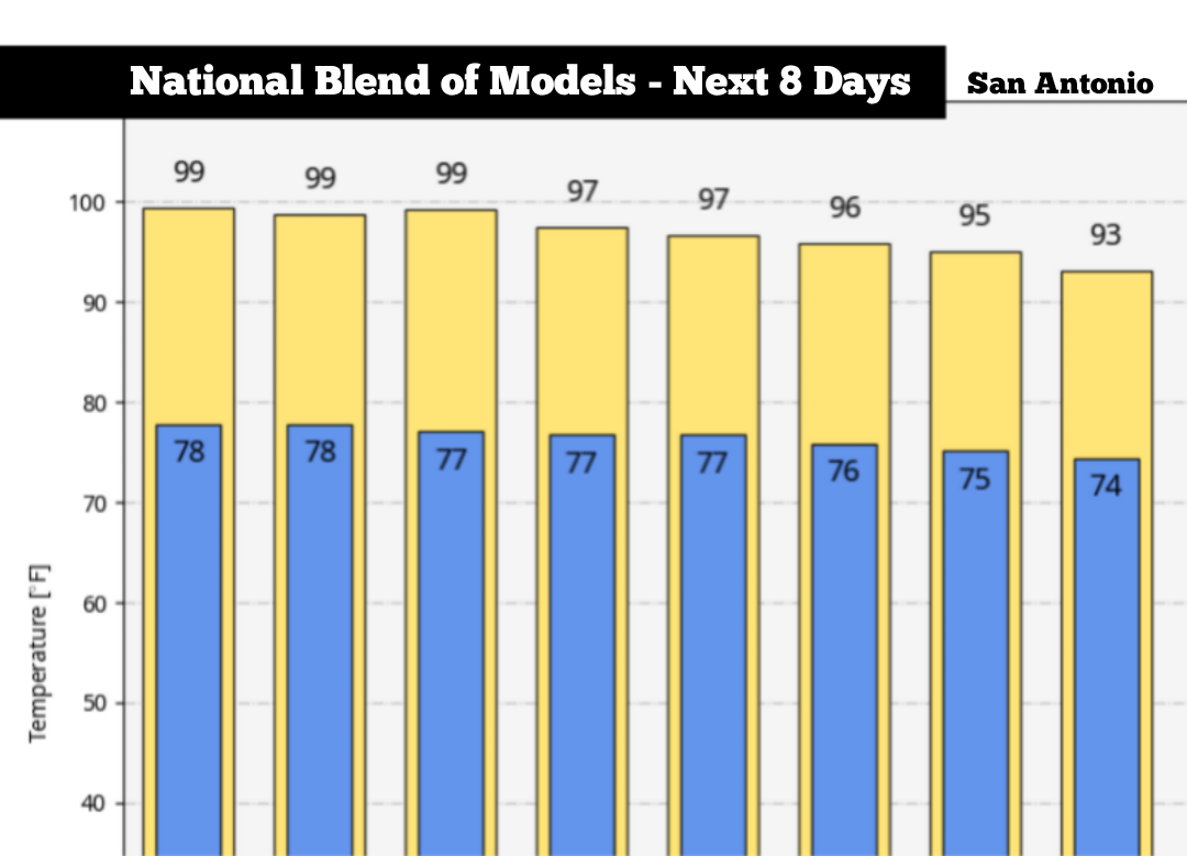
Conditions are expected to stay relatively stagnant through the first half of the work week. San Antonio can expect high temperatures in the upper 90s to near 100 degrees from Monday through Wednesday, with daily low temps falling into the upper 70s.
High humidity will also continue to be a factor, resulting in heat index values between 105 and 107 degrees each day.
By the second half of the week, high pressure will begin to weaken, allowing for temps to drop by a few degrees. On Thursday and Friday, San Antonio highs are expected to top out at 96 to 97 degrees with about a 20% chance of scattered showers and thunderstorms.
During the upcoming weekend, models are showing that a low-pressure system is likely to move across the Central Plains, north of San Antonio. This system may bring a weak cold front into Texas, especially by Sunday.
Because this is still a week away, high levels of uncertainty still exist in regards to how strong or how far south the cold front will move. That said, there is potential for temperatures to drop into the low to mid-90s by Sunday, with higher chances for showers and thunderstorms as well. Be sure to stay with expressnews.com/weather for future updates as this forecast evolves.