
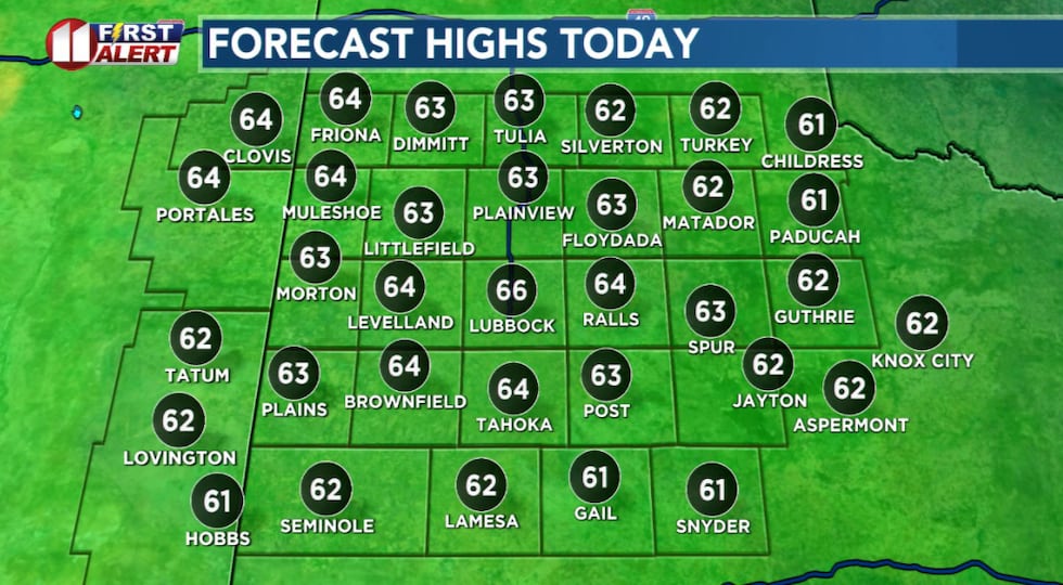
LUBBOCK, Texas (KCBD) – After freezing to near freezing temperatures this morning, near average highs this afternoon. Then several days this week temperatures will peak near record highs.
The overall pattern will remain nearly stagnant through the work week. A broad area of low pressure, a trough (or trof), will persist over much of the northeastern US while its counter-balance, an area of high pressure, a ridge, continues over the US Desert Southwest.
 This afternoon sunny, breezy, and cool.(KCBD First Alert)
Weather across the KCBD/FOX34 viewing area largely will be under the influence of the ridge. As this ridge gradually shifts east and nearer our area, skies will remain generally fair, successive afternoons will warm a bit more each day, nights will get chilly, and winds will be light to breezy.
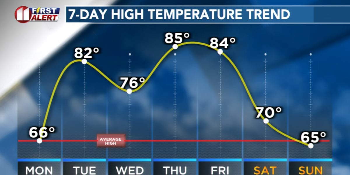
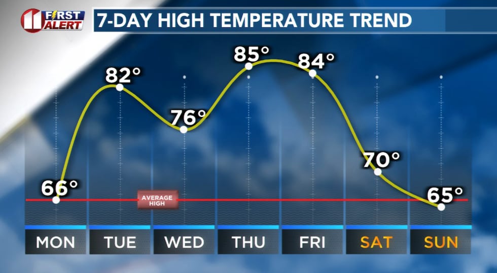
Highs today will peak slightly below to near average for the time of year. For Lubbock, the November 10 average high is 66° and the record 85° (in 1927). The average low is 38° and the record low 19° (in 1950).
Possible Record Highs
Highs tomorrow and again late this week are likely to hit the low to mid-80s in the Lubbock area. This is near record territory. Lubbock’s record high for
 Highs today will peak slightly below to near average. Tomorrow and again late this week highs climb to near record territory.(KCBD First Alert)
Monday 85° set in 1927
Tuesday is 82° in 1956
Wednesday 85° in 1995
Thursday 82° in 1973
Friday 85° 1933
Currently, Thursday is expected to be our warmest day of the week.
Our Next Weather Maker
A Pacific storm system is anticipated to move onto the West Coast late in the week. It will bring heavy rain to California Wednesday night through Friday with heavy snow in the mountains. Possibly three or more feet of snow in the Sierras.
The system may bring snow to the mountains of northern and western New Mexico by Saturday.
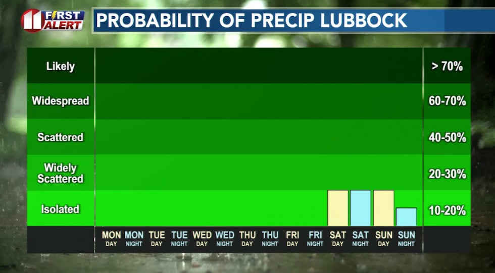 A weather system currently over the Pacific Ocean may bring showers to West Texas late Saturday.(KCBD First Alert)
As this same system moves east it is likely to send a cold front through the viewing area early Saturday. Following an increase in humidity ahead of the front, a cool rain and a few thunderstorms are possible in the South Plains area late Saturday through early Sunday. At this time, though, the most likely time appears to be Saturday night.
In regard to the above, there is a lot of time and a lot of ground to cover before late-week changes are realized. There’s a lot of room for changes to the outlook between now and then. We will keep our eyes on it and continue fine tuning our forecast throughout the week.
On This Date
1991: An incredible display of northern lights unfolded late in the evening over a large portion of the United States, including all of West Texas. Coincident with the maximum of an 11-year solar sunspot cycle, a powerful solar flare affected the Earths upper atmosphere and produced brilliant curtains of red in the sky as far south as Arkansas. (National Weather Service Lubbock)
Copyright 2025 KCBD. All rights reserved.