
Early this football season, UTSA is 2-0 with wins over UT-Rio Grande Valley and Texas State. On Saturday, the Roadrunners will have their toughest test of the season as they make the short trip up Interstate 35 to take on the Texas Longhorns in Austin. But not only will UTSA be facing an elite Texas team, they’ll also have to contend with high heat Saturday evening.
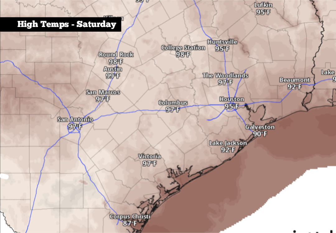
If you’re heading to the game, be prepared for near-record temperatures. The hottest weather will occur during the pregame festivities, with highs expected to reach 99 degrees in downtown Austin. Folks tailgating along Bevo Boulevard or attending the pregame concert on the LBJ lawn will need to stay properly hydrated, as humidity-driven heat index values will rise to around 103 degrees.
Temperatures will cool slightly by the 7 p.m. kickoff, but they are still likely to be near 93 to 95 degrees. The air will be slow to cool, with temps likely falling only into the 80s by the start of the second half. While warm, Austin has little to no chance of rain or lightning, so the game should not face any weather-related delays.
Saturday: Similarly hot weather is expected in the San Antonio area. Early in the morning, temperatures will hover in the mid- to upper 70s under partly cloudy skies. By the afternoon, highs are expected between 96 and 98 degrees with mostly sunny skies overhead. Humidity will stay elevated, leading to heat index values of up to 102 degrees.
While San Antonio did see a few scattered showers and storms move through the city on Friday, rain chances Saturday will be much lower, as high pressure strengthens overhead. An isolated shower is not impossible, but rain chances will be less than 10%.
Sunday: No significant changes are expected Sunday, as temperatures will once again rise to around 97 degrees in San Antonio — about 8 degrees above average for mid- to late September. Partly cloudy skies are expected, but rain chances will be slim to none.
By Monday, a weak cold front is likely to progress into parts of Texas. However, this front is projected to stall out across parts of North and Central Texas, likely staying about 200 miles north of San Antonio.
Because the front will stay relatively far away, temperatures will not be affected in a big way and will likely reach the upper 90s across South-Central Texas. An isolated shower or storm will be possible, but rain chances will only be around 20% in the Alamo City.
The weather will stay relatively stagnant heading into the second half of the week. You can expect temperatures as high as 96 or 97 degrees from Wednesday through Friday. With atmospheric moisture levels staying high, an isolated shower or storm chance also will remain possible, although widespread rain is not expected.
Long-range weather models still favor above-average temperatures continuing into the end of the month. By the start of October, however, a more active weather pattern could develop. Be sure to stick with expressnews.com/weather for continued daily updates.