
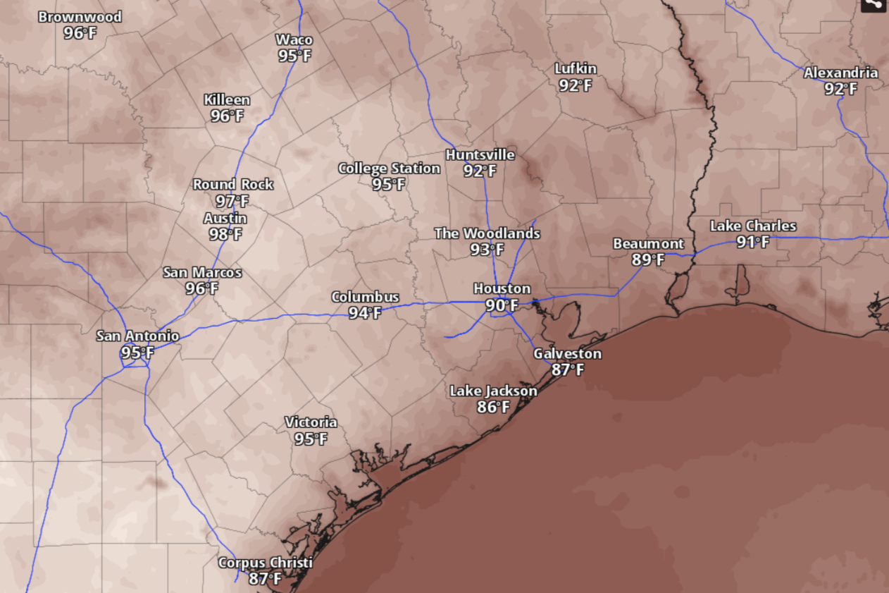
Temperatures will be in the lower 90s across Southeast Texas by 4 p.m. Sunday, according to the National Blend of Models.
National Blend of Models/Pivotal Weather
A combination of a potent system of low air pressure and deep surge of Pacific atmospheric moisture could lead to plenty of unsettled weather across Southeast Texas this week. It could lead to multiple inches of rainfall in Houston but also milder, more seasonable temperatures.
Until then, however, the Houston metro area will have to suffer through a few more days of summer-like heat and dry weather, according to the National Weather Service.
What’s the Sunday forecast?
Houston on Sunday is shaping up to be a mostly sunny day with afternoon temperatures reaching 94 degrees, which would be several degrees warmer than normal for the city in late September. With southeast winds kicking up later in the day, delivering moisture-rich air from the coast, expect cloudier skies in the evening. Overnight temperatures should stay above 75 degrees through dawn on Monday.
Article continues below this ad
“With a little more moisture in the area, expect a hot and slightly more humid Sunday with isolated diurnally-driven showers and storms,” the weather service said in a forecast bulletin posted online Saturday. Diurnally-driven rains are showers triggered by increases in heat during the daytime, according to forecasters.
They added that “this weather pattern looks to remain at least through Tuesday with isolated to scattered activity mainly in the afternoon with the sea breeze.”
Monday and Tuesday forecast
Houston on Monday should be sunny, with temperatures again climbing to an unseasonable 94 degrees. Southeast winds of 5 to 10 mph in the afternoon will lead to partly cloudy skies at night, with evening temps bottoming out around 76 before sunrise Tuesday.
Article continues below this ad
Rain chances start to enter the forecast by Tuesday, when Houston has a 20% shot at showers and thunderstorms after 1 p.m. Otherwise, expect mostly sunny skies, with temperatures staying in the lower 90s. During a mostly cloudy Tuesday night, temperatures will stay above a balmy 78 degrees.
“After Tuesday, the weather pattern changes with increasing rain and thunderstorm chances, peaking from Wednesday into the weekend,” the weather service said.
Rain chances midweek
Southeast Texas will be on the receiving end of moisture from two sources, according to forecasters.
Article continues below this ad
“Gulf moisture will kick in as persistent southeasterly (air) flow continues,” the weather service said in its bulletin. “At the same time, deep Pacific moisture will filter over the Plains.”
Meanwhile, a deepening upper-level trough of low air pressure will move over the western United States and merge with atmospheric moisture generated by Hurricane Polo, forecasters said.
For Houston, that means Wednesday comes with a 60% chance of rain and storms in the afternoon. The rain-cooled air will keep maximum temperatures limited to 91 degrees. At night, rain chances will ease to 40% as overcast skies help keep evening temps above 77 degrees, which would still be about 10 degrees warmer than normal.
“Confidence in a wetter pattern toward mid-late week continues to increase; however, confidence on timing, rain coverage and rainfall amounts still remains low,” the weather service said.
Article continues below this ad
The National Blend of Models, a composite weather forecast model, anticipates between 2 and 4 inches of cumulative rainfall over the coming days through next Friday.
National Blend of Models/Pivotal Weather
Late-week rain chances
“Overall, the probability of getting rainfall amounts greater than 1 inch is around 20-35% for Wednesday, 50-60% for Thursday, and 30-40% on Friday,” the weather service said. “The probability of rain greater than 2 inches is slightly lower: 20-25% Wednesday, 30-45% Thursday, and 15-25% Friday.”
Houston on Thursday has a 60% chance of showers and thunderstorms during the day and a 40% chance at night. On Friday, rain chances ease slightly to 50% during the day.
Article continues below this ad
“Given the spread in models regarding the evolution of this trough… the main takeaway at the moment is to focus on impacts and not total amounts,” the weather service said. “Prepare for periods of showers and thunderstorms, mainly Wednesday into Friday. Finer details will be provided as confidence increases.”