
Texas weather can flip from one extreme to another in a matter of days, and that’s exactly what we’re in for this week. We’ll go from wrapping up one of the hottest Septembers on record to the potential for flooding rain during the first few days of October.
This video created with the assistance of AI.

But until the big pattern change arrives, Tuesday will remain hot, humid and breezy. We’ll start the day with mostly cloudy skies, light southeast winds and temperatures in the mid-70s. Clouds will linger through midday as winds increase to 5 to 12 mph, with gusts of up to 20 mph.
By the afternoon, a few breaks in the clouds will allow temperatures to climb into the mid- to upper 90s, with humidity driving up heat index values to as high as 102 to 104 degrees. A few coastal showers could develop and drift toward the Interstate 35 corridor after lunch, but rain chances will remain low at around 20%.

High temperatures across Central and South Texas on Tuesday will be about 8 to 10 degrees hotter than normal for the end of September. (Pivotal)
When do the rain taps get turned on?
Wednesday will be the day when we flip the rain switch to “on.” We’re tracking an upper-level system of low air pressure, a cold front, a plume of tropical moisture from the Pacific Ocean, and abundant atmospheric moisture from the Gulf of Mexico. All these ingredients will come together to produce several days of possibly heavy rainfall across Central Texas.
“The current consensus among the more skillful (forecast) models suggests heavy frontal rains could commence as early as Wednesday night, slowly advancing east during the night and throughout the day Thursday,” meteorologists at the National Weather Service wrote in their daily forecast discussion for Austin and San Antonio. “Risks of excessive rainfall capable of causing flash flooding applies to all of South-Central Texas during this period.”

Rain chances in Austin ramp up on Wednesday and continue through the weekend with the highest potential from Wednesday night through Friday. (National Weather Service)
While confidence is high that Austin will see widespread rain during this time, confidence remains lower about where the heaviest rainfall will be, how quickly the cold front will move, and when exactly the worst of the storms will happen.
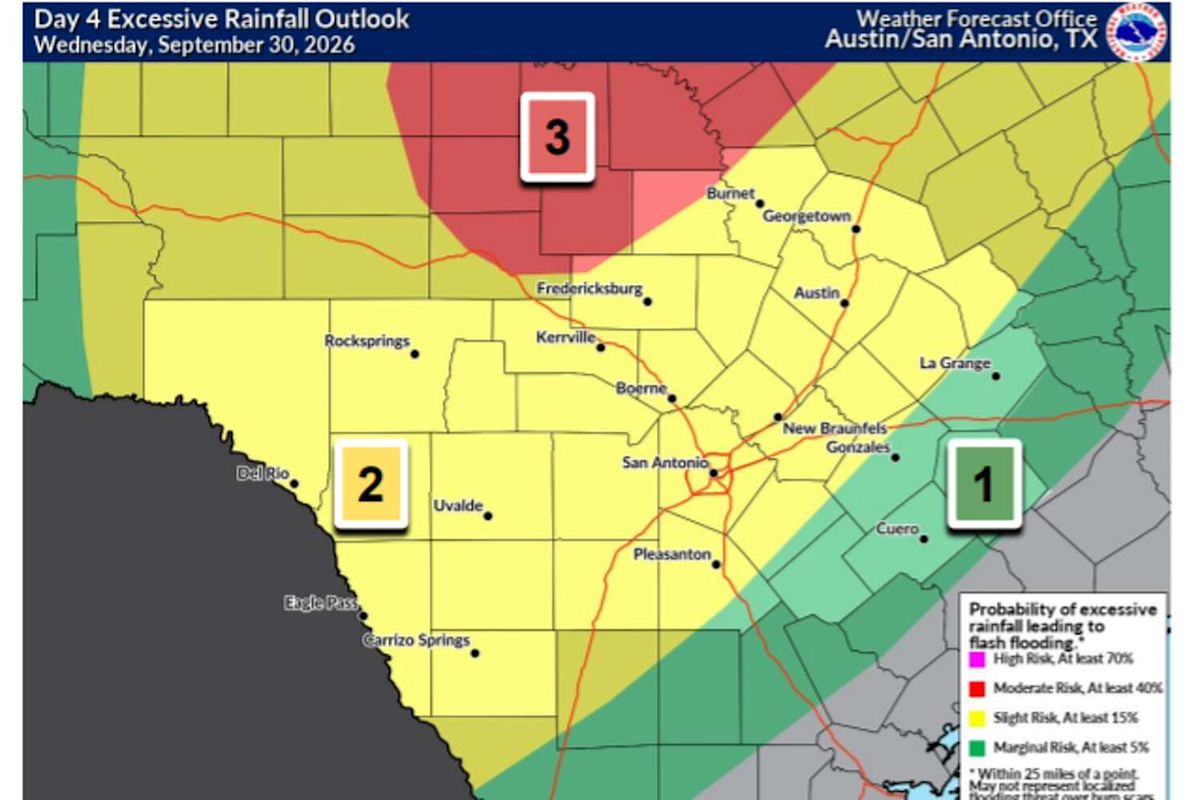
Current rainfall projections call for 3 to 5 inches across Central Texas from Wednesday through Saturday, with isolated amounts of up to 6 inches possible.
With that amount of rain expected, the National Weather Service placed the Austin area at a level 2 of 4 risk, or at least a 15% chance, for excessive rainfall and flash flooding during that time.
ACL FORECAST: Will ACL Fest get rained out this weekend? Here’s the latest flood forecast for Central Texas
Will we finally unlock fall temperatures?
Wednesday afternoon temperatures will continue to be hotter than our late September normal high of 88 degrees, with temps climbing into the mid-90s.
The Pacific cold front, widespread rainfall and increased cloudiness should bring daytime temperatures down to slightly below average levels on Thursday and into the weekend. If you can believe it, Austin will see maximum daytime temperatures in the lower to mid-80s through early next week.
With the forecast still evolving, be sure to check back frequently at statesman.com/weather and for the latest updates, follow instagram.com/wassonweather, x.com/Mary_Wasson and facebook.com/MeteorologistMaryWasson.
This article originally published at How hot will Central Texas get Tuesday before rain arrives? Here’s what you can expect..