
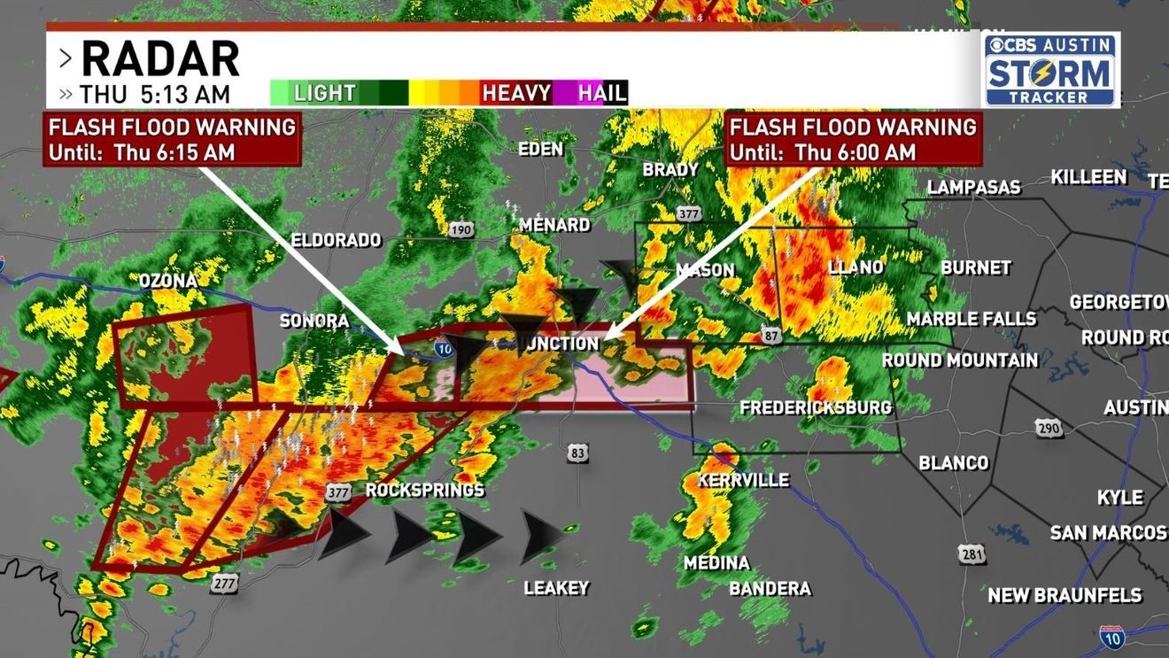
AUSTIN, Texas — The Llano River is expected to flood over the next couple of days as heavy rain continues to soak the Hill Country, with up to 9 inches already falling around Junction by Thursday morning.
As of 8 a.m., the river gauge in Junction had jumped to 9 feet and 10,000 cubic feet per second, up from about 1 foot and a few hundred cubic feet per second before the rain began, CBS Austin Meteorologist Avery Tomasco said.
The river was still rising quickly, and tributaries that meet in Junction were also rising sharply.
Heavy rain in Mason and Llano counties could add to the flood wave as it moves downstream.
Tomasco said the river will flood to some degree long after the rain ends, but how severe it will be is hard to determine until all the rain is accounted for and the wave moves through Mason County. Anyone near the Llano River should stay alert.
A Flash Flood Warning is also in effect for Gillespie County, west of Fredericksburg, and Kerrville until 2 p.m. Tomasco said 1 to 2 inches had already fallen there, with another 2 inches or more likely over the next couple of hours.
Some creeks and streams could rise enough to cover low-water crossings, but Tomasco wrote that it “isn’t another major Guadalupe River flood in the making.” The Llano is the only major waterway expected to flood, though conditions could change through the day.
So far, most of the Hill Country has picked up 1 to 3 inches of rain, with isolated totals of 7 to 9 inches around Junction and more expected through late morning. Tomasco said most of the Hill Country will end up with at least 3 inches.
Months of drought have left the soil dry, but there’s still too much rain for the ground to absorb, Tomasco said. The Hill Country’s shallow soil and steep terrain send runoff quickly into creeks, streams and rivers, which is why the region is known as Flash Flood Alley.
The storms are expected to reach the I-35 corridor by late morning or early afternoon. Tomasco said the flood threat in the Austin area appears lower because the storms are expected to speed up as they move east, but the area could still see 1 to 3 inches of rain, along with possible flooding at low-water crossings and in poorly drained areas. The afternoon commute is expected to be messy along and east of I-35.
If a cold front moves through quickly, Thursday night could be quieter than first expected, with mainly light showers and a few storms into Saturday. Tomasco cautioned that the forecast could still change.
Even after the flash flood threat eases, river flooding and downstream impacts on the Highland Lakes are possible through the weekend.
Rain will continue at Zilker Park for the start of ACL Weekend One, but temperatures will stay in the 70s for the first time in months.