
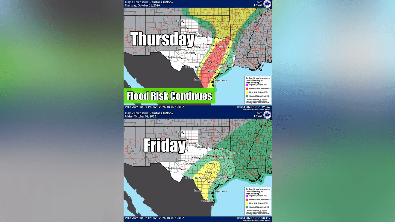
AUSTIN, Texas — The threat of flooding is increasing across Central Texas Thursday evening as a stalling cold front brings repeated rounds of heavy rain, while runoff from earlier storms continues to push down the Llano River.
Most of the CBS Austin viewing area remains under a Flood Watch through 7 p.m. Friday. The watch has been expanded to include Lee and Fayette counties, while Mason County has been removed.
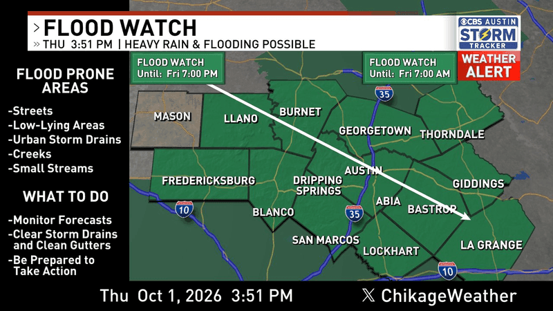
Most of the CBS Austin viewing area remains under a Flood Watch through 7 p.m. Friday. The watch has been expanded to include Lee and Fayette counties, while Mason County has been removed.
CBS Austin Chief Meteorologist Chikage Windler says the most critical period for additional heavy rain and possible flooding is expected from Thursday evening through Friday morning.
The first round of storms dropped up to 5 inches of rain in Mason County, where numerous roads were reported closed. More than 4 inches have also fallen in parts of Llano and Burnet counties.
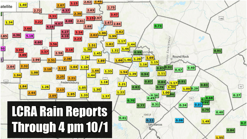
The first round of storms dropped up to 5 inches of rain in Mason County, where numerous roads were reported closed. More than 4 inches have also fallen in parts of Llano and Burnet counties.
Atxfloods.com reported 11 road closures as of 4 p.m. Thursday, and that number could increase as additional rain moves over some of the same areas.
Llano River expected to reach flood stage
The Llano River is also being closely monitored as runoff from heavy rain upstream continues to move downstream.
More than 7 inches of rain fell upstream in Junction Thursday morning. The Llano River is now forecast to reach moderate flood stage in Llano Friday morning and minor flood stage in Mason.
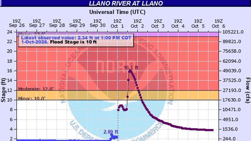
The Llano River is also being closely monitored as runoff from heavy rain upstream continues to move downstream. More than 7 inches of rain fell upstream in Junction Thursday morning. The Llano River is now forecast to reach moderate flood stage in Llano Friday morning and minor flood stage in Mason.
The Lower Colorado River Authority currently does not expect flood operations, though conditions could change as runoff continues downstream.
Earlier Thursday, CBS Austin Meteorologist Avery Tomasco reported the river gauge in Junction had jumped to 9 feet and 10,000 cubic feet per second by 8 a.m., up from about 1 foot and a few hundred cubic feet per second before the rain began.
Heavy rain that fell farther downstream in Mason and Llano counties could add to the flood wave as it moves through the watershed.
More heavy rain expected overnight
In Austin, both Camp Mabry and Austin-Bergstrom International Airport were approaching 1 inch of rain as of 4 p.m., with more expected.
The progression of showers and storms has slowed as the cold front to the west stalls. That could allow rounds of rain to repeatedly move over the same areas.
A steady stream of deep tropical moisture is moving southwest to northeast along the I-35 corridor from San Antonio to Austin. A second corridor of heavy rain is also developing east of I-35, with pockets of more than 3 inches reported in southwest Fayette County.
Both areas are expected to remain the focus for additional heavy rain and storms through early Friday morning.
Another 1 to 4 inches of rain is possible from I-35 eastward, with isolated locations potentially receiving an additional 5 to 10 inches.
Windler stressed that the higher totals represent a very isolated, worst-case scenario for only a few locations. Forecast models have not locked in exactly where those pockets could develop, though areas along or east of I-35 appear to have the greatest potential.
Central Texas remains under a Level 3 of 4 flood risk through 7 a.m. Friday, followed by a Level 2 of 4 risk for Friday.
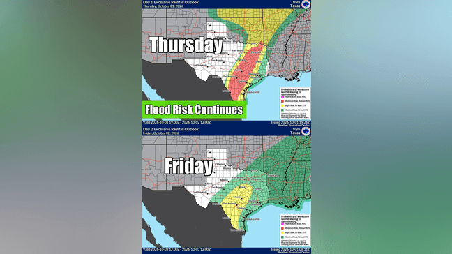
Central Texas remains under a Level 3 of 4 flood risk through 7 a.m. Friday, followed by a Level 2 of 4 risk Friday.
The severe weather threat has diminished as temperatures have dropped into the low 70s and instability has decreased. However, deep tropical moisture and remaining atmospheric energy will keep the heavy rain threat going overnight.
Drivers should never attempt to cross flooded roads. Turn Around, Don’t Drown.
Rain chances increase for ACL weekend
The heaviest rain is expected to move out Friday morning, but the forecast for the first weekend of the Austin City Limits Music Festival has become wetter.
Some forecast models now show scattered showers and storms redeveloping later Friday into Friday night, with additional chances Saturday and Sunday.
CBS Austin’s latest forecast calls for a 100% chance of rain Friday, 70% Saturday and 50% Sunday.
Festivalgoers should continue monitoring the forecast as the timing and location of additional storms could change.
This is a developing weather situation. Stay with CBS Austin for the latest forecast and updates.