
The winter-like chill Houston felt earlier this week is fading fast as a warming trend takes hold.
Daily highs in the 80s are expected through the end of the week, but a weekend cold front may bring slightly cooler, wetter weather. Still, lasting fall chill remains absent from the forecast.
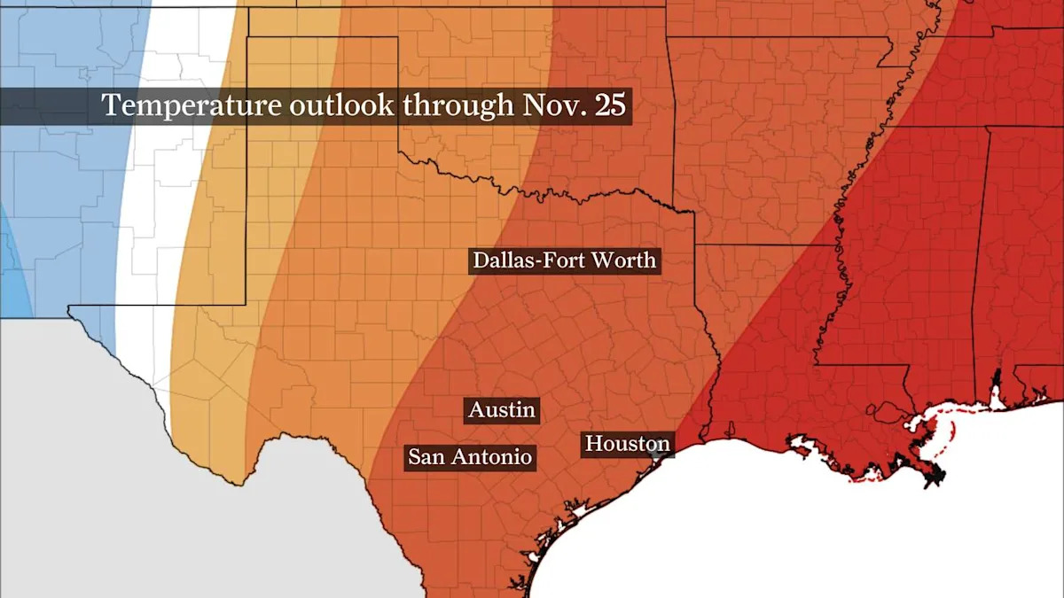
WHAT WILL WINTER BRING?: Texas’s winter weather outlook has been released. How will La Niña influence it?
Before we look ahead to this weekend’s front, let’s take a quick look back at how cold it actually got.
Goodbye, cold mornings
Morning lows Tuesday at Houston’s official climate site, Bush Intercontinental Airport, bottomed out in the upper 30s. Some neighborhoods just north of the city even experienced their first frost of the season.
Temperatures early Wednesday started 15 to 20 degrees warmer across Southeast Texas, meaning most of us woke up to temperatures in the 50s. Morning lows warm slightly by Thursday and Friday morning as areas north of Interstate 10 fall into the 50s and Houston points south settle generally in the lower 60s.
As dew points continue to climb Friday into the weekend ahead of a cold front, morning temperatures inch closer to the middle and upper 60s.
Houston highs reach into the 80s
Southerly winds lock highs into the 80s for Houston through Friday.
Temperatures peak around 82 or 83 degrees Wednesday, but could inch towards the mid-80s Thursday and Friday. Typical highs in mid-November hover near the mid-70s, so we’ll be running roughly 10 degrees above average through the end of the week.
You’ll also notice a bit more humidity in the air as dew points hover in the middle 60s. This could result in a few more clouds bubbling up during the afternoon, leaving the crisp blue skies earlier this week in the past.
Daily records in mid-November are mostly in the upper 80s, so it doesn’t look like we’ll tally any additional record temperatures at Bush Intercontinental.
Weekend showers possible
Houston’s next chance for showers arrives this weekend, most likely beginning Sunday. Saturday should stay mostly dry, though warm by mid-November standards near 85 degrees.
TEMPERATURE TRACKER: From above normal heat to below normal chill, track the ups and downs here.
Increased cloud cover and slightly better rain odds arrive Sunday, though forecast models are trending later in the day. In fact, the bulk of shower activity may not arrive until early Monday morning.
Why is there so much uncertainty?
The system responsible for this weekend’s spotty shower or storm chance is still taking shape over the Pacific. Until it comes ashore along the West Coast Thursday, timing and specific forecast details will continue to need fine-tuning.
{ “__type”: “devHubFreeformEmbed”, “__id”: “Datawrapper”, “__fallbackImage”: “https://datawrapper.dwcdn.net/aR3vg/mobile.png”, “__data”: { “datawrapper_id”: “aR3vg” } }
Once that system moves through early next week, attention turns to what could follow behind it.
Forecast models hint at a stronger cold front late next week. It’s still too early to know whether it could finally bring lasting fall chill, but for now, Houston’s cooler weather looks temporary at best.
This article originally published at Houston can’t keep its chill: When will sweater weather finally last?.