
A summer-like high pressure system has developed and is sitting directly over the Lone Star State on Sunday. Because of it, temperatures are set to soar across the state, with some areas potentially rising close to the 90-degree mark.
San Antonio will even have a chance to tie or break a record that was originally set in the 1930’s.
Thankfully, this weather pattern is not expected to last long. By the middle to second half of the week, large-scale weather pattern changes are anticipated across the entire state, bringing a cold front and the region’s best rain chances in the last several weeks. Here’s a breakdown of what you can expect.
Sunday’s forecast
Expect a mild and humid morning as low temps hover in the mid-60s under partly to mostly cloudy skies. Skies will start to clear as we head into the late morning and afternoon, allowing temps to rise quickly throughout the rest of the day.
Temperatures will already be in the mid-70s by 10 a.m., reaching the 80-degree mark between 11 a.m. and noon. By 3 p.m., afternoon high temps are expected to top out at 85-87 degrees in the San Antonio metro area, possibly tying or breaking the 87-year old daily record of 86 degrees, which was set in 1938.
Temperatures will drop back into the 70s after 6 p.m., but things will stay quite through the evening. San Antonio won’t drop under 70 degrees until after midnight.
Meteor shower tonight: The Leonid meteor shower will peak between midnight tonight and 6 p.m. Monday morning. Viewing conditions look somewhat favorable across South Texas, as mostly clear skies after midnight become partly cloudy early Monday morning.
The Leonids will produce between 5 and 15 meteors per hour. For the clearest view, head away from city lights and look east toward the Leo constellation. You may still be able to spot a few from within the city, but light pollution will likely limit the show to just a handful per hour.
Upcoming weather changes
Warm and very humid conditions are expected to continue Monday and Tuesday across the region. San Antonio will start each morning with low temps in the mid- to upper 60s, while afternoon highs top out in the mid- to upper 80s, under partly sunny skies.
By Wednesday, the state will start feeling the effects from an approaching low-pressure system, which originated over the Pacific Ocean. Scattered showers and storms are expected, especially over Central and West Texas. Rain chances in San Antonio on Wednesday will be about 30-40%.

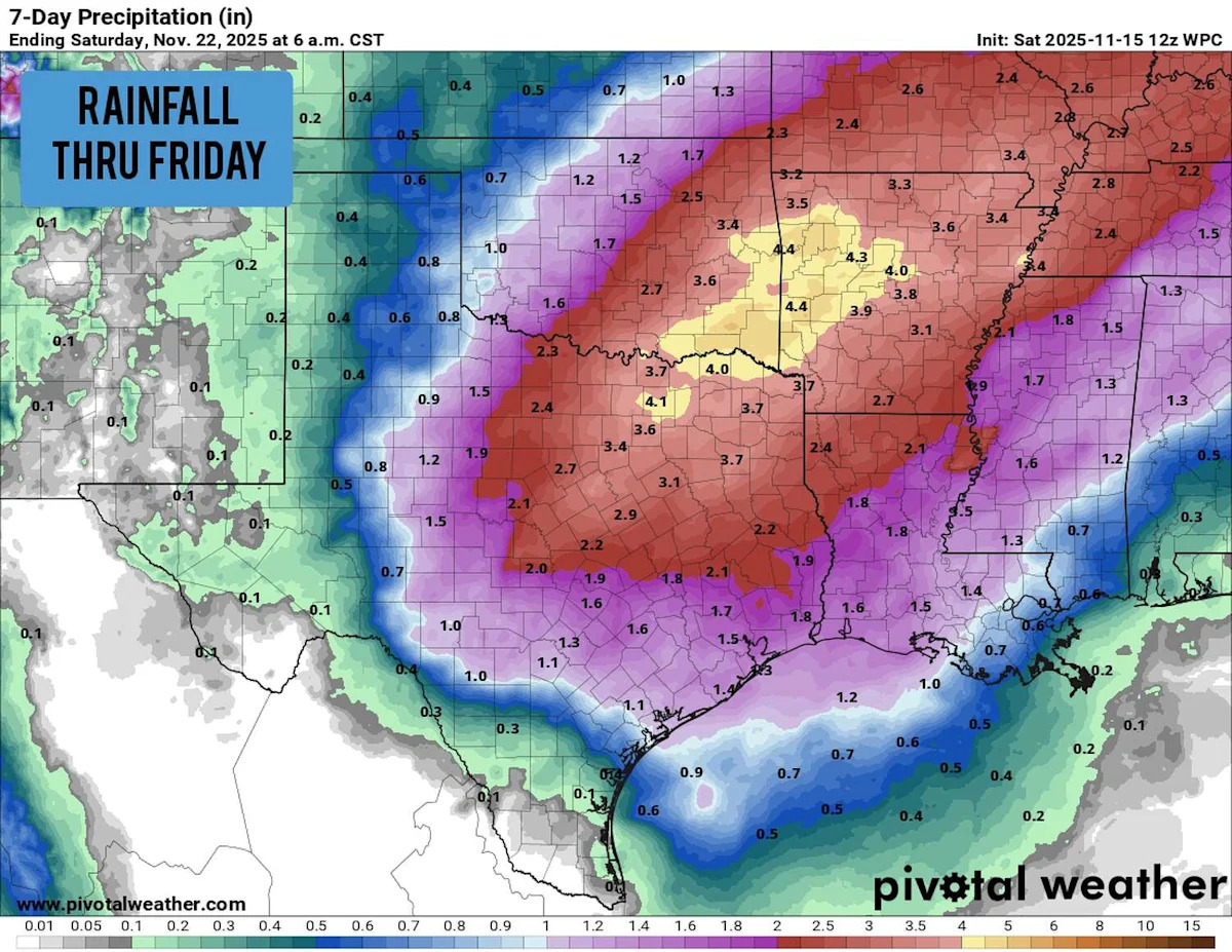
Shown are the potential rainfall totals this week, mostly from Wednesday through Friday morning. (Pivotal Weather)
San Antonio’s rain chances will surge to around 60-70% on Thursday, as a potential line of storms moves across the state during the late afternoon and evening. This line of storms will have the potential to bring severe weather, including large hail and damaging winds to the region. However, it’s too early to tell exactly where the strongest activity will set up.
Several inches of rain is possible across parts of Central, North and East Texas on Wednesday and Thursday. Rainfall totals in San Antonio will likely be a bit lower, but between 1-2 inches is within the realm of possibility. Be sure to stay with expressnews.com/weather for daily updates as the details of this system become more clear.
This article originally published at San Antonio may break 87-year old record on Sunday. Here’s what to expect..