
Late fall warmth continues in Houston this week, but a major pattern change could finally deliver much-needed rain.
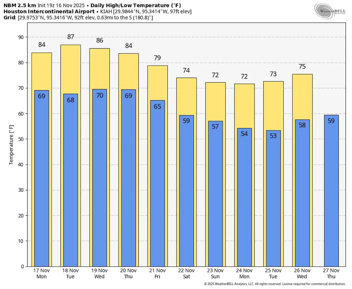
Cooler and wetter weather remains out of the forecast through midweek. Daily records could be matched or broken as highs run 10 to 15 degrees above normal.
Here’s what you need to know about this week’s record warmth and the major changes that could arrive in time for the week of Thanksgiving.
Record heat persists this week
The forecast through Wednesday is what meteorologists call a “persistence forecast.” Essentially, the weather you experience today will likely be the same tomorrow and the day after.
HEAT TRACKER: You can track Texas’s warm fall using the Houston Chronicle’s interactive heat tracker here.
Patchy dense fog is possible each day through 9 or 10 a.m. this week as morning temperatures start between 68 and 72 degrees. For context, Houston’s normal high in mid-November is around 73 degrees.
{ “__type”: “devHubFreeformEmbed”, “__id”: “Datawrapper”, “__fallbackImage”: “https://datawrapper.dwcdn.net/NBhM5/mobile.png”, “__data”: { “datawrapper_id”: “NBhM5” } }
High temperatures through midweek are expected to top out in the middle to upper 80s. Daily records at Houston’s official climate site, Bush Intercontinental Airport, are in the mid-80s. It’s possible that at least a few days bring either tied or broken daily records.
An unusually warm and moisture-rich air mass for mid-November could result in an isolated storm chance by Wednesday. More likely storms, some strong, arrive Thursday.
Stormy Thursday possible
An upper-level low is expected to move from the Desert Southwest into the Southern Plains by Thursday, sending a cold front into the Houston area.
Forecast guidance generally depicts the cold front’s arrival between Thursday afternoon and early Friday. While specifics will be fine-tuned over the next three days, the potential is there for strong storms Thursday. Houston sees a second severe weather peak during the fall months, with November standing out as the most active month for tornadoes locally.
There is still a lot of uncertainty regarding how Thursday’s storm risk unfolds. A line of thunderstorms, as suggested by most models, would likely result in a damaging wind and isolated tornado risk.
Be sure to keep an eye on future Houston Chronicle forecasts this week as details become more clear regarding Thursday’s storm risk.
Cooler, wetter days ahead
Behind Thursday’s cold front, a wetter and cooler pattern is expected.
FALL DROUGHT: As Southeast Texas drought worsens, history shows how bad a dry fall season can get.
The drop in temperatures likely won’t be dramatic, with highs Friday only a handful of degrees cooler than Thursday in the upper 70s. A reinforcing shot of cooler weather may arrive over the weekend, possibly sending highs into the mid-70s with morning lows into the 50s.
Those hoping for truly chilly (chili?) weather may have to wait a bit longer. While models hint at cooler days, temperatures are likely to slip only to near or slightly above normal.
Cooler or more typical temperatures could come alongside much-needed soaking rain. After Thursday’s storms, daily showers are possible through the upcoming weekend.
The forecast grows more uncertain deeper into Thanksgiving week – unsurprising this far out. A second stretch of wet weather could return in the days before Thanksgiving, possibly lasting beyond Black Friday.
This article originally published at Hang in there, Houston. Cooler weather and rain are on the horizon..