

LUBBOCK, Texas (KLBK) — Here is your updated forecast from the KLBK First Warning Weather Center:
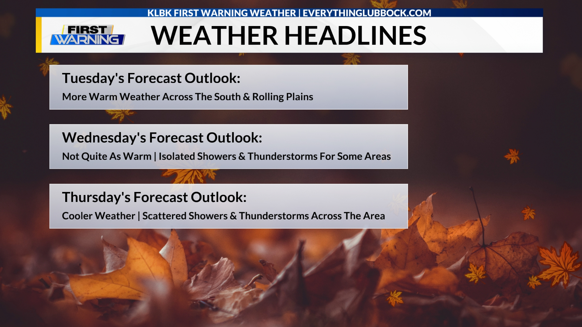 KLBK Weather Headlines
(Valid: Tuesday, November 18)(Nexstar Media Inc./EverythingLubbock.com/KLBK News)
Today:
Partly cloudy conditions and continued warm weather is forecast on this Tuesday across the South Plains and the Rolling Plains. Once again, high temperatures will vary across the region and range from the lower 70s to the middle 80s. The wind will be out of the west-southwest 5 to 15 mph.
Sunrise is at 7:22 AM CST.
Tonight:
Mostly cloudy conditions and mild to warm weather is forecast this evening and tonight. Low temperatures will range from the middle 40s to the middle 50s. The wind will be out of the south-southwest 5 to 10 mph.
Sunset is at 5:43 PM CST.
Wednesday:
Mostly cloudy to cloudy conditions and not quite as warm weather is forecast on Wednesday. South Plains and the Rolling Plains. There is a slight chance for showers and thunderstorms in the afternoon for some areas. High temperatures will range from the lower to the upper 70s The wind will be out of the west 5 to 15 mph. The chance for rain is 20 percent.
Sunrise is at 7:23 AM CST. Sunset is at 5:42 PM CST.
• iPhone Users: Download our “EverythingLubbock Weather” app via the Apple App Store
• Android Users: Download our “EverythingLubbock Weather” app via Google Play
Extended Forecast:
Isolated showers and thunderstorms are forecast on Wednesday across portions of the South Plains and the Rolling Plains. Scattered showers and thunderstorms are forecast on Thursday across portions of the South Plains and the Rolling Plains. Scattered showers are forecast on Sunday and Monday across portions of the South Plains and the Rolling Plains.
Daytime highs on Tuesday will vary and range from the lower 70s to the middle 80s. Wednesday’s highs will range from the lower to the upper 70s. Highs on Thursday will range from the lower 60s to the lower 70s. Friday’s highs will range from the upper 50s to the upper 60s. Highs on Saturday and Sunday will be in the lower and the middle 60s. Forecast daytime highs on Monday will be in the middle and the upper 60s.
Low temperatures on Wednesday and Thursday morning will range from the middle 40s to the middle 50s. Friday’s morning lows will range from the middle 30s to the middle 40s. Lows on Saturday will range from the lower 30s to the lower 40s. Sunday’s and Monday’s morning lows will range from the middle 30s to the middle 40s.
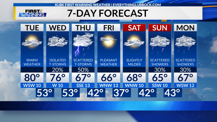 KLBK AM 7-Day Forecast
(Valid: Tuesday, November 18)(Nexstar Media Inc./EverythingLubbock.com/KLBK News)
• Follow KLBK’s First Warning Weather on Facebook
• Follow KLBK’s First Warning Weather on X
Drought Update:
Drought conditions continue to increase across the majority of the South Plains and the Rolling Plains, according to the latest update of the U.S. Drought Monitor (USDM) released on Thursday, November 13.
Moderate stage (D1) drought conditions are in place across portions of the Rolling Plains and portions of the far northern South Plains. Meanwhile, abnormally dry (D0) conditions continued to be reported across the rest of the Rolling Plains and most of the South Plains.
USDM data indicated abnormally dry (D0) conditions remain in place across the Lubbock metro area.
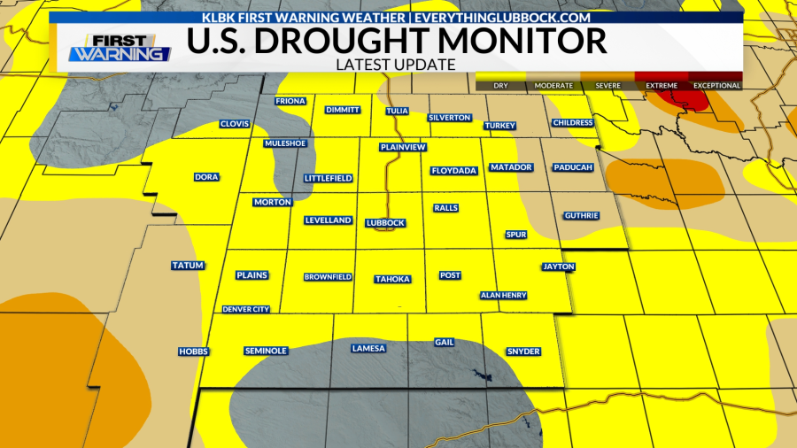 Latest U.S. Drought Monitor Update
(As of Thursday, November 13)(Nexstar Media Inc./EverythingLubbock.com/KLBK News)
• Visit KLBK’s First Warning Weather Center Online
Lubbock Climate Data for Tuesday, November 18:
Sunrise: 7:22 AM CST
Sunset: 5:43 PM CST
Normal High: 63°
Normal Low: 35°
Record High: 82° (1942/1999)
Record Low: 16° (1951)
• Download the “EL+” streaming app to watch KLBK News on Roku, Apple TV & Amazon Fire TV
• Local News Coverage From KLBK News & EverythingLubbock.com
Your KLBK First Warning Forecast:
Today: Partly cloudy and continued warm. Variable highs ranging from the lower 70s to the middle 80s. West-southwest wind 5-15 mph.
Tonight: Mostly cloudy and mild to warm. Lows ranging from the middle 40s to the middle 50s. South-southwest wind 5-10 mph.
Wednesday: Mostly cloudy to cloudy and not quite as warm. A slight chance for showers and thunderstorms in the afternoon for some areas. Highs ranging from the lower to the upper 70s. West wind 5-15 mph. The chance for rain is 20 percent.
Meteorologist Chris Whited
KLBK First Warning Weather
cwhited@klbk13.tv
Facebook: Meteorologist Chris Whited
X: @severewxchaser
Bluesky: severewxchaser