
Tuesday:
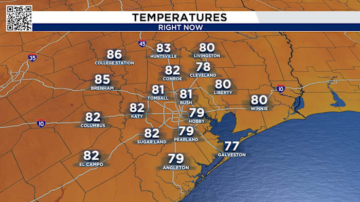
We’ll start Tuesday with patchy fog before 8 am then a high in the 80s. The record high is 86 in 2004, so we’ll keep a close eye on our temperatures!
Tracking the heat on Tuesday (Copyright 2025 by KPRC Click2Houston – All rights reserved.)
From record highs to wet weather:
The next chance for rain? Thursday, ahead of a front that will knock down our highs from the 80s into the seasonable 70s next week. But first, we’re tracking isolated thunderstorms on Thursday. Of course, the timing can change – heavy rain, gusty winds and minor flooding are all possible.
Thursday strong cold front (Copyright 2025 by KPRC Click2Houston – All rights reserved.)Rainfall totals for this week (Copyright 2025 by KPRC Click2Houston – All rights reserved.)Your extended forecast:
Behind Thursday’s cold front, temperatures will continue to fall back in the 70s. The next time we’re waking up in the 50s looks to be this weekend! There will also be an additional rainmaker next mid-week that could bring in some messy driving conditions if you’re heading out before the holiday.
10 day forecast (Copyright 2025 by KPRC Click2Houston – All rights reserved.)Click 2 Pins
If you notice interesting weather in your neighborhood, share your photos and videos with KPRC 2 at Click2Pins!
Anthony’s Weather Lab
Houston’s weather and other cool things explained by KPRC 2’s Chief Meteorologist Anthony Yanez
Copyright 2025 by KPRC Click2Houston – All rights reserved.