

A low-pressure system has moved into the Desert Southwest, and as it continues to move eastward, it will bring showers and thunderstorms into the Lone Star State.
The highest rainfall totals and flooding risk is expected across parts of the Hill Country, southern Concho Valley and along the Rio Grande. However, widely scattered thunderstorms may still move into the San Antonio metro area, especially by Thursday evening. Here’s the latest timeline for what you can expect Thursday and as we head into the weekend.
Forecast timeline
Early morning (4 a.m. to 9 a.m.): Early morning heavy rainfall is expected from Del Rio northeastward into the Hill Country. The heaviest rain will likely move out of the region after sunrise.
Meanwhile, isolated showers and areas of drizzle are possible in the San Antonio metro area throughout the morning. Heavy rain, though, is not expected as temperatures likely hover in the low 70s, about 20 degrees above average for this time of the year.
Midday (10 a.m. to 5 p.m.): A few scattered showers and weak storms are possible in and around Bexar County, with overall rain chances rising to around 50%. Still, most of the heavier rainfall is expected to stay north and west of the city.
A second round of strong storms is expected to move into the western Hill Country during the early afternoon. This cluster will continue eastward, affecting cities such as Kerrville and Fredericksburg after 2 to 3 p.m.
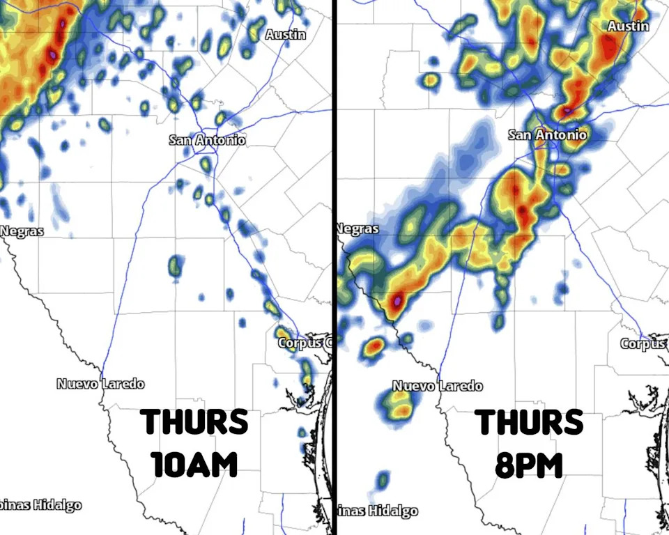
Shown is a look at the future radar at 10 a.m. Thursday (left), as well at 8 p.m. Thursday (right), as a potential line of storms move into San Antonio. (Pivotal Weather)
Evening (5 p.m. to 11 p.m.): The highest rain chances of the day are expected across the San Antonio metro area during this time, especially after 6 to 7 p.m. as a broken line of storms moves through. Storms will be widely scattered, meaning that parts of the Alamo City may still miss out on significant rainfall.
A few storms could be strong, capable of hail and strong wind gusts. Thankfully, large hail is not expected to be a widespread issue.
How much rain will fall? Most of San Antonio will record less than an inch of rainfall, with some seeing a half-inch or less. A few spots could see more than an inch, but that will depend on exactly where the strongest storms develop – which is difficult to pinpoint. Slightly higher rainfall totals are also expected just north of San Antonio, from San Marcos to Austin.
Much of the Hill Country, including Kerrville and Fredericksburg, will see 1-3 inches of rainfall. Even higher rainfall totals are expected farther west, from Del Rio to Rocksprings and Junction. Here, isolated rainfall totals of 6 inches or more are possible.
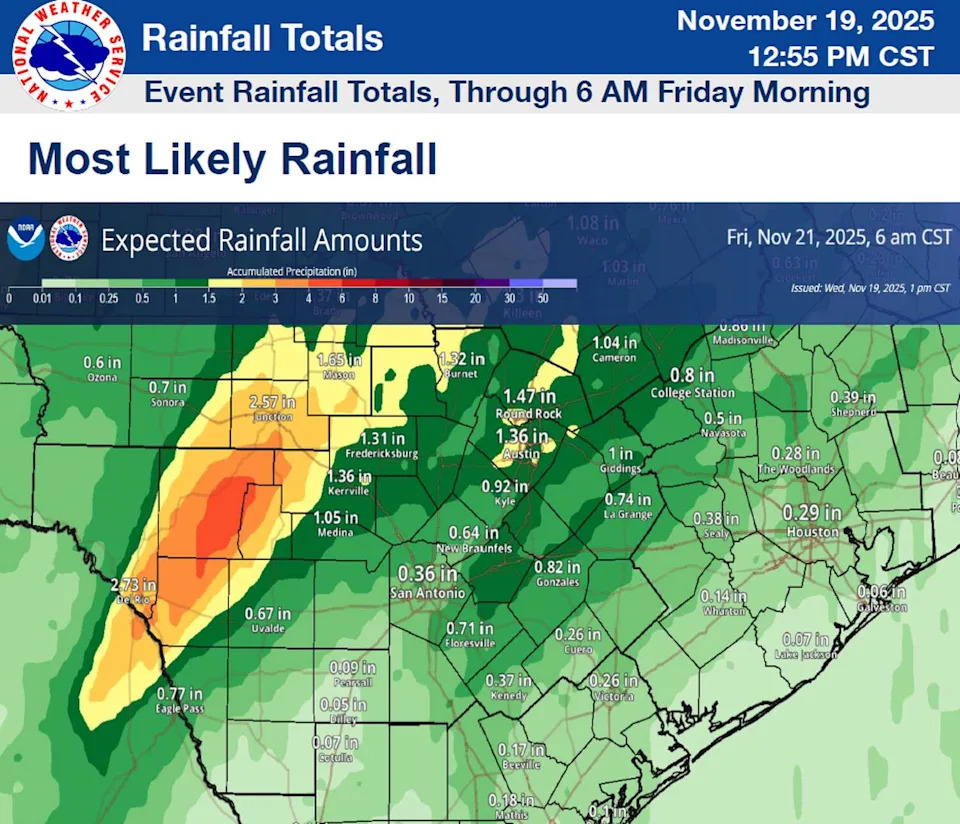
Shown is a look at potential rainfall across South Texas on Thursday. The highest rainfall totals are expected northwest of San Antonio, across the Hill Country. (nws austin/san antonio)
More rain coming this weekend
A few scattered showers and weak storms are possible Friday morning, but by the second half of the day, mostly sunny skies are expected to return, at least temporarily. High temperatures will stay above-average, topping out in the upper 70s to low 80s.
A second low-pressure system is expected to move into the Desert Southwest over the weekend, bringing another chance of significant rainfall to the region. On Saturday, chances will be relatively low, with only a 20%-30% chance of a few showers throughout the day.
Rain chances will rise on Sunday, especially by late Sunday night and into early Monday. Once again, though, the heaviest rainfall is likely going to stay north of San Antonio into parts of Central Texas and the Hill Country.
This article originally published at Will San Antonio see strong thunderstorms today? Here’s the forecast timeline..