
LUBBOCK, Texas (KCBD) Here is a live stream of radar and weather cameras:
update 3:01 p.m. – The visibility has improved in Lubbock, with the wall of dirt moving farther east. Scattered showers and storms are moving east, heaviest from Plainview to Dimmit.
update 2:34 p.m. – Dust is being kicked up by gusty wind moving into Lubbock now. A dust storm warning is in effect for Lubbock, W Crosby and S Hale counties until 3 p.m.
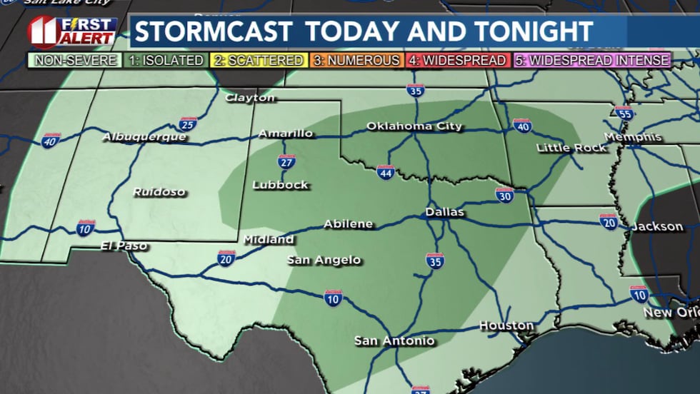
Scattered showers and storms are moving across the South Plains. The heaviest rain now is moving from near Shallowater to Olton, quickly lifting NE over the northern South Plains.
update 2:09 p.m. – A severe thunderstorm warning has been issued for Hockley County until 2:30 p.m. The core of this storm is near Levelland, moving NE at 50mph. It is capable of producing 60mph gusts and hail up to the size of pennies.
update 1:20 p.m. – A line of showers and thunderstorms is spreading west to east, with individual showers and storms moving from southwest to northeast. The strongest parts of this line could produce some gusts to 50mph along with small hail.
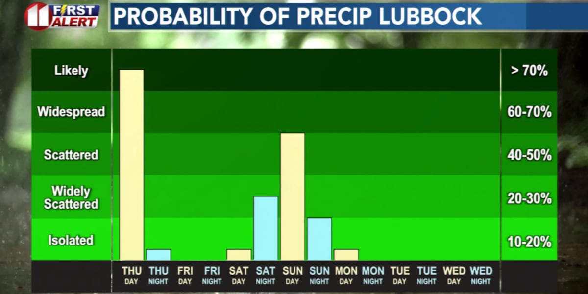
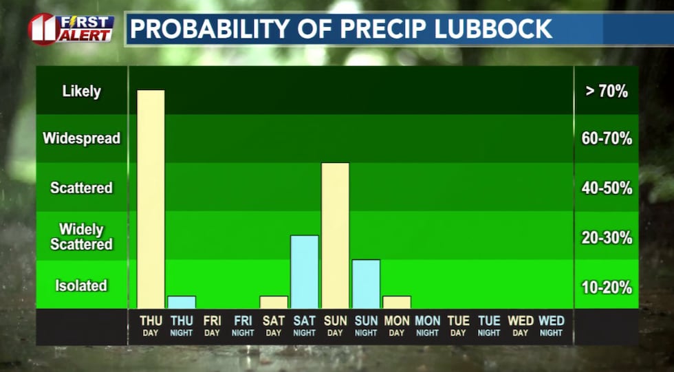
posted Thursday morning – Rain is likely today. Some spots may see their greatest rain totals in more than two months. Today, however, is not the only chance of measurable rainfall.
TODAY
Rain may not be continuous, in fact, I don’t expect it to be. But rain is likely at times. Amounts around 1/10 to 1/4 inch are likely but around an inch to an inch-and-a-half, give or take, are possible in spots. Heavier amounts are expected to favor the eastern KCBD/FOX34 viewing area.
 There is a slight chance some storms today may become marginally severe.(KCBD First Alert)
The heaviest rainfall will accompany thunderstorms. Some of these may be strong with hail up to quarter-size and wind gusts up to 60 mph. Be weather aware, watch for warnings which may be issued.
The last significant rainfall in our area was more than two months ago. Lubbock measured 0.87″ on September 14. Lubbock’s last measurable rainfall, 0.08″, was October 25.
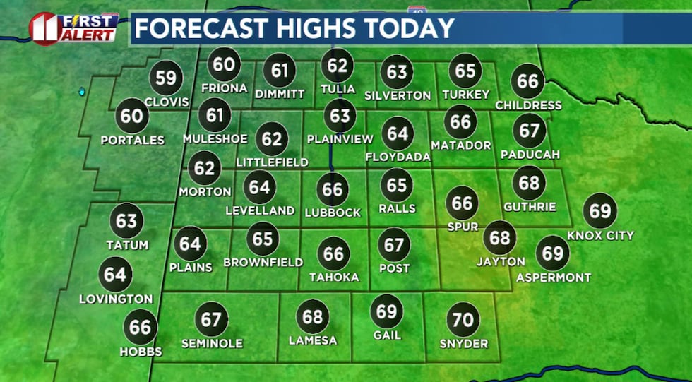 Cool today with highs a few degrees above average for the date.(KCBD First Alert)
Temperatures will peak near to slightly above seasonal averages, with highs generally in the 60s. Average temperature extremes for Lubbock this time of year range from a low of 35° to a high of 62°. The records for the date are 17° (1937) and 88° (1996).
WEEKEND
I expect dry weather tomorrow and Saturday. Highs both days in the Lubbock area will range from the mid-60s to near 70 degrees. The low tonight will drop into the low 40s. Friday night will be a little colder, with a low in the upper 30s.
 Rain is likely at times today, mainly this afternoon.(KCBD First Alert)
Current data points to a good chance of more rain late this weekend. It’s a slight chance late Saturday night, increasing to likely Sunday. Rain may linger into early Monday over the eastern viewing area.
THANKSGIVING WEEK
After the rain chance ends early Monday, dry weather is expected through Thanksgiving day and again on Black Friday. Mornings will be quite chilly to a bit cold. Afternoons will be cool. Possibly quite cool.
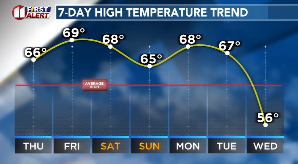 Lubbock-area Highs from the mid-60s to near 70 degrees through early next week.(KCBD First Alert)
As I’ve noted in the past, when we are looking at a forecast that is more than five days out the potential for changes is certainly possible. Thanksgiving is still a full 7 days away. We’ll continue to watch the data, which streams into the First Alert Forecast Center every hour of every day.
You can watch for possible changes by occasionally checking this page – specifically the forecast section (scroll down the page just a bit after closing this story), or our weather app (search your app store for “kcbd weather), our any of our newscasts (either live or replay through any of our digital platforms).
ON THIS DATE
November 20, 1994: Strong west winds whipped across the South Plains with gusts as high as 63 mph measured at the Lubbock Airport. High winds toppled a gas station canopy onto a car in Seminole. A mother and her two children in the car were not injured. Blowing dust reduced visibility to a half-mile at times.
(National Weather Service Lubbock)
Copyright 2025 KCBD. All rights reserved.