
It’s been an extremely dry fall across Southeast Texas thus far, but Houston was finally able to pick up at least some rainfall Saturday morning, recording 0.6 inch at George Bush Intercontinental Airport. Since Sept. 1, only 5.26 inches of rain has fallen in Houston, which is on pace for the driest fall in the city’s history.
Heavy rain, with the potential of flooding, is expected to develop across parts of North Texas from Sunday evening through Monday. Houston’s rain chances, though, will likely be delayed until late Monday and into Tuesday. Here’s what you can expect.
Sunday’s forecast
With dry air in place over Southeast Texas, a beautiful day is expected across Houston. Morning temps will start cool, hovering in the upper 50s to near 60 degrees from 5 to 8 a.m. Temperatures will rise steadily thereafter, reaching 70 degrees from 11 a.m. to noon, under partly cloudy skies.
By mid-afternoon, Houston will be treated to warm temps with highs in the mid- to upper 70s. While a few showers are possible in areas farther west toward Victoria and San Antonio, Houston will likely stay dry throughout the day.
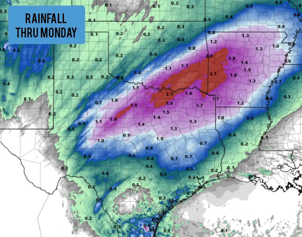
Shown are the potential rainfall totals across Texas through Monday, according to the National Blend of Models. (Pivotal Weather)
Heavy rain in North Texas: By Sunday afternoon, widely scattered thunderstorms are expected to develop across West Texas and the Panhandle. These will push eastward and become more widespread as we head into the Sunday night and early Monday.
The heaviest rainfall from Sunday night through Monday will be across North Central Texas. A wide swath of 1 to 3 inches of rain is expected in Abilene, the DFW Metroplex, Sherman-Denison and Texarkana. Isolated higher amounts up to 5 inches are also possible, especially toward the Red River.
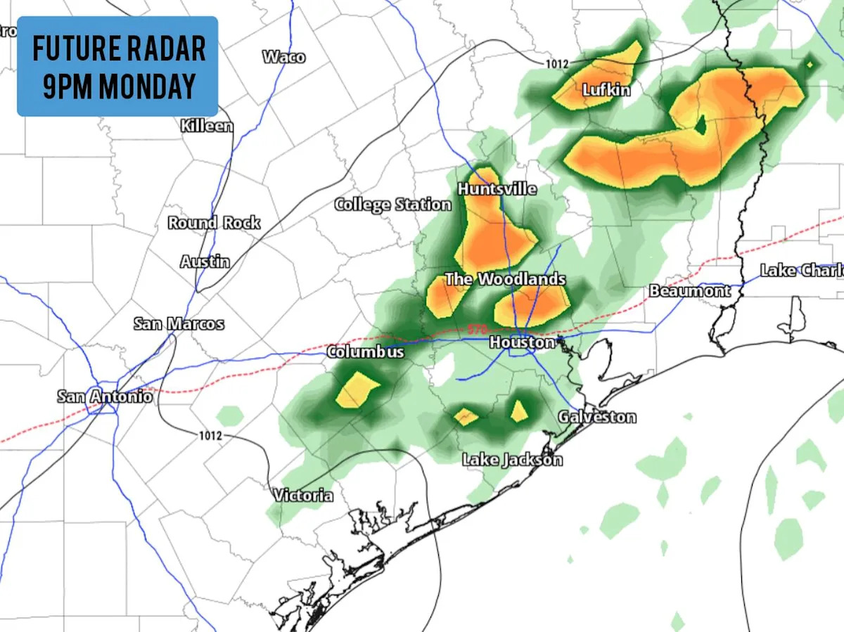
Houston rain chances
By Monday afternoon and evening, the plume of moisture over Central and North Texas will move eastward, likely bringing a chance of thunderstorms into the Houston area. The best chance of storms will be after 5 p.m. Monday, continuing into the overnight hours and early Tuesday morning.
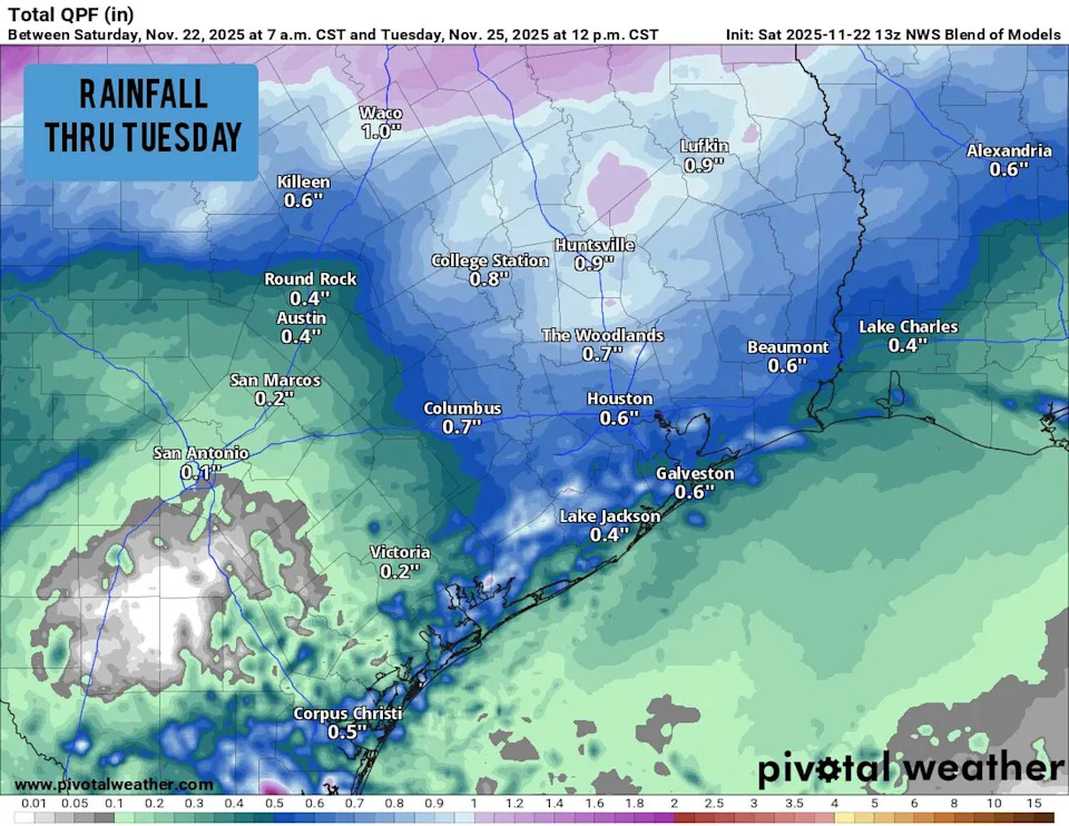
Shown are the potential rainfall totals across Southeast Texas through Tuesday, according to the National Blend of Models. (Pivotal Weather)
Overall rain chances in Houston during this time are about 60%, so not everyone will see significant rainfall. For those that do see rain, totals are not expected to be very high, with most spots across the region picking up less than 1 inch of rain.
A few isolated higher rainfall totals of up to 2 inches are possible, resulting in potential urban street flooding for some. Additionally, the strongest storms may also produce hail and strong winds, but severe weather and flooding threats are not expected to be widespread.
Later this week
After the storms move out of the region on Tuesday, sunny skies and warm conditions will return as highs rise into the upper 70s to near 80 degrees. More changes are coming by the middle of the week, though, as a cold front sweeps through the region Tuesday night and into early Wednesday.
The front will bring about a 10-degree drop in high temperatures from Tuesday to Wednesday, as Houston tops out near 70 degrees. Even cooler weather is expected for Thanksgiving; morning lows are expected to drop into the upper 40s while afternoon highs likely stay in the mid- to upper 60s.
The next significant chance of rain is not likely across southeast Texas until Saturday, as a potential low-pressure system approaches from the west.
This article originally published at Houston thunderstorm chances set to rise early this week. Here’s what to expect..