
An intense winter storm is developing across the Midwest on Saturday, and it’s likely to bring between 8 and 16 inches of snow across large parts of Iowa, Wisconsin, Illinois, Indiana, and Michigan. Major holiday travel delays are expected in cities like Chicago, Indianapolis and Milwaukee.
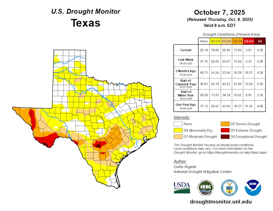
Closer to home, the same storm system will bring a cold front and high storm chances into Southeast Texas, likely providing beneficial rainfall to the Houston area, which has been experiencing worsening drought this fall.
Unfortunately, it comes during a busy travel weekend for Texans. Heavy rain, a few strong storms, and localized flooding could all slow travelers coming into or leaving Houston following the Thanksgiving holiday. Here’s what you need to know about this weekend’s wet weather, plus a look ahead to a cold start to December.
 Stormy Saturday night for Houston
A potent cold front is on track to reach Houston overnight tonight, and it’s going to make for a messy weekend.
Before the front arrives, much of Saturday will be dry. However, a few showers may still dot the radar, so if you have plans to support local shops for Small Business Saturday, try to get out before 4 or 5 p.m. Any rain before late afternoon should be fairly light and shouldn’t cause many issues on area roads.
EMERGING DROUGHT: Southeast Texas drought worsens, and history shows how bad a dry fall season can get.
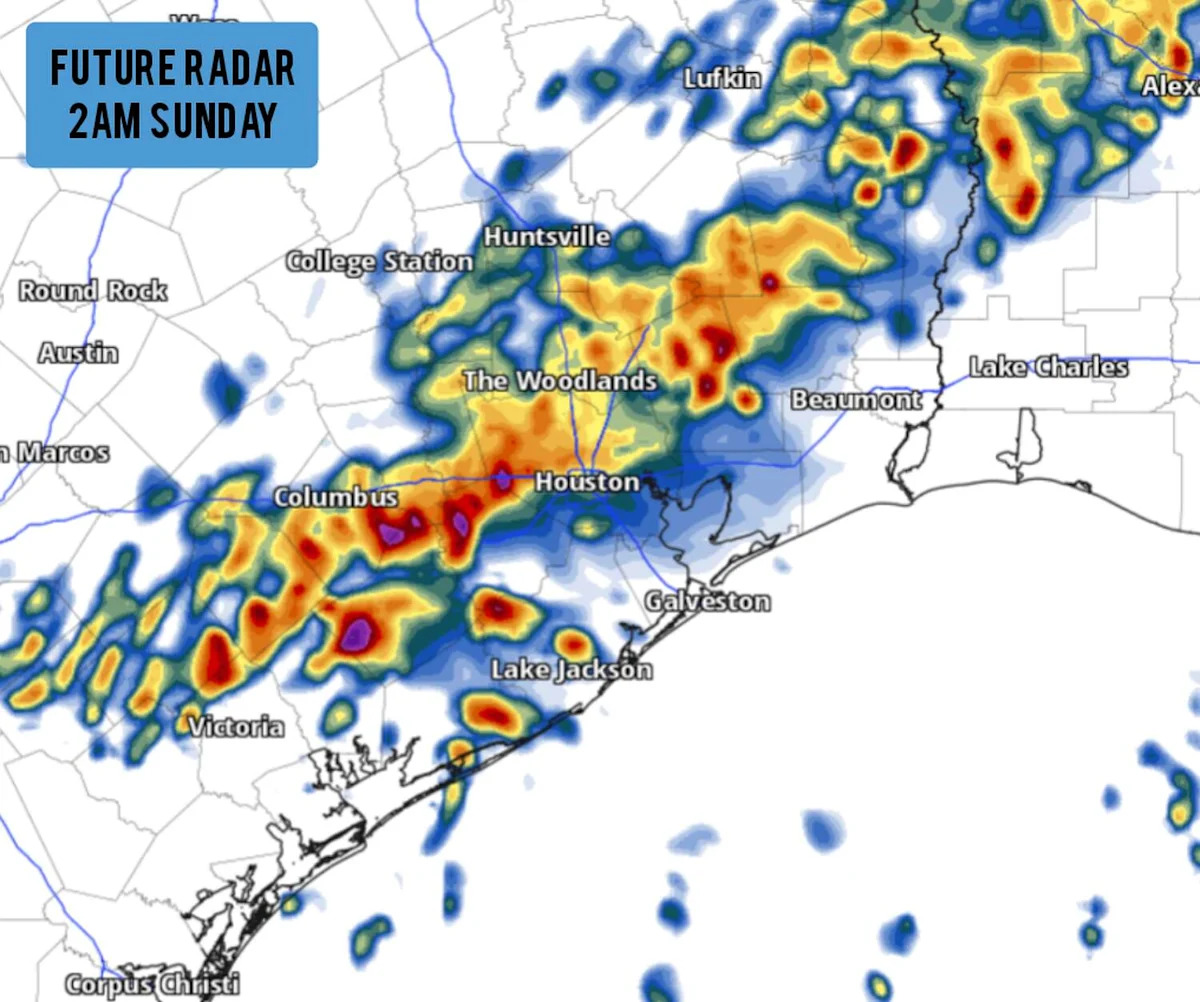
Rain chances will increase to around 30-40% during the late afternoon and evening as high temperatures rise into the mid-70s. During this time, rain chances will be higher north and west of Houston, toward College Station, Huntsville, and Conroe.
Storm chances continue to increase overnight as a cold front approaches from the northwest and collides with a relatively warm and moist air mass. The best chance of storms will occur between 11 p.m. Saturday and 6 a.m. Sunday morning.
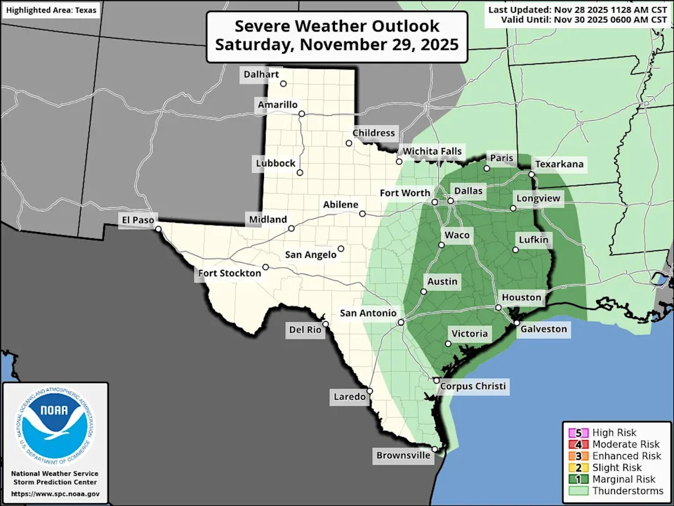
Shown is the SPC outlook for late Saturday night into early Sunday. A few storms could produce large hail and damaging winds in Southeast Texas. (Storm Prediction Center)
As we witnessed Monday when two confirmed tornadoes spun up across Greater Houston, this time of year can certainly produce severe storms. Saturday night’s storms are no exception. The Storm Prediction Center has issued a Level 1 of 5 risk of severe storms, with a few storms capable of large hail and damaging wind gusts.
An isolated tornado can’t be ruled out overnight, however the tornado threat is very low.
Additionally, you’ll want to take it easy on the roads, as heavy rain overnight and early Sunday could result in minor street flooding. If you come across a flooded road, always turn around and seek an alternate route.
Cold start to December
Behind our weekend cold front, temperatures take a significant drop.
By Sunday, as cold air funnels in from the north, daytime temperatures are only expected to reach around 55 degrees. The chilly weather will continue Monday and Tuesday, as highs are likely to only reach the low to mid-50s, levels more typical of mid-January than early December.
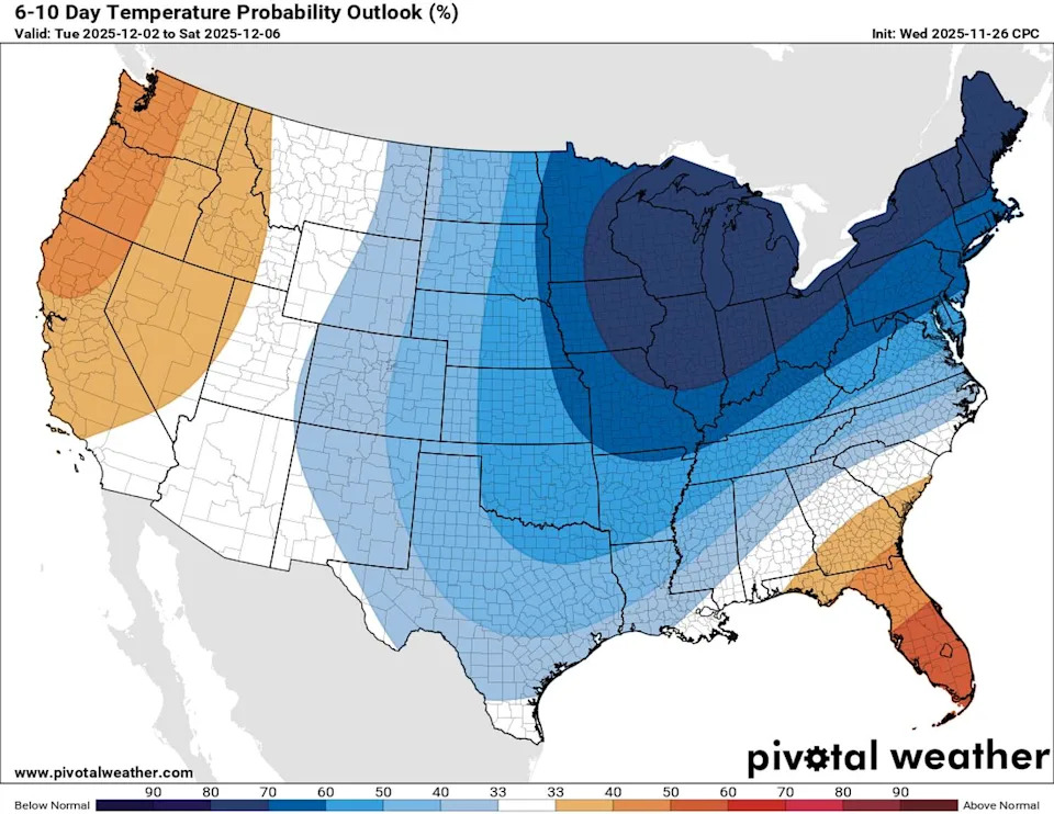
This map shows temperature outlooks through the first week of December across the nation. Shades of blue indicate where temperatures are expected to be below normal, while above normal temperatures are shown in orange. (Climate Prediction Center / Pivotal Weather)
If daytime temperatures are expected to be this cold, you know morning temperatures will be even colder. Morning low temperatures from Monday through Wednesday will drop into the low to mid-40s across the Houston metro area.
NOVEMBER TORNADOES: As November comes to a close, Southeast Texas says goodbye to it’s most active month for tornadoes.
Will the rest of December be cold?
Next week, at least through Wednesday, could bring some of the coldest air of the season to Houston.
But as so many other times have shown this fall, it doesn’t guarantee lasting cold air. Temperatures may warm back to the upper 60s to low 70s by next weekend.
The best way to assess how cold, or not, December will be is to look at the Climate Prediction Center’s outlook. While this outlook doesn’t show how far below or above normal temperatures will be, it does show confidence that temperatures will lean above normal.
Obviously, above normal warmth in December means a very different thing than it does in July. But if you’re a fan of cold weather, you may have to put your hopes for a consistently cold December on ice.
This article originally published at Strong cold front arrives in Houston overnight, a few severe thunderstorms possible.