
LUBBOCK, Texas (KCBD) – Generally fair skies will continue through the week and into the weekend with a few clouds from time to time. It is a dry pattern that will persist through at least mid-month. There are two cold fronts, however, that will pass through the area this week.
Patchy fog may hamper visibility over the northeastern viewing area around sunrise this morning. Other than that, just a bit of high, thin, cloud cover.
Sunny today with some thin cloud cover at times, breezy, with highs about ten degrees above average for the second week of December. Southwesterly winds around 10 to 20 mph from midday until late afternoon.
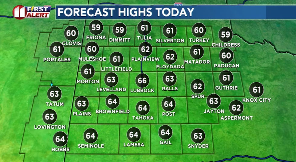 Highs from near 60 to the mid-60s Monday afternoon, five to ten degrees above average for the time of year.(KCBD First Alert)
Low temperatures, though cold some mornings, will be rather mild for the time of year. The average low for Lubbock this time of year is around 29 degrees.
The record low for Lubbock for this date, December 8, is 3° in 1917. The record high is 78° on this date in 1970.
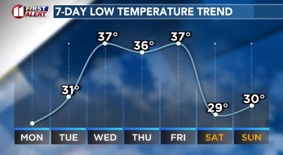 Some cold nights and mornings, but near to above average low temperatures.(KCBD First Alert)
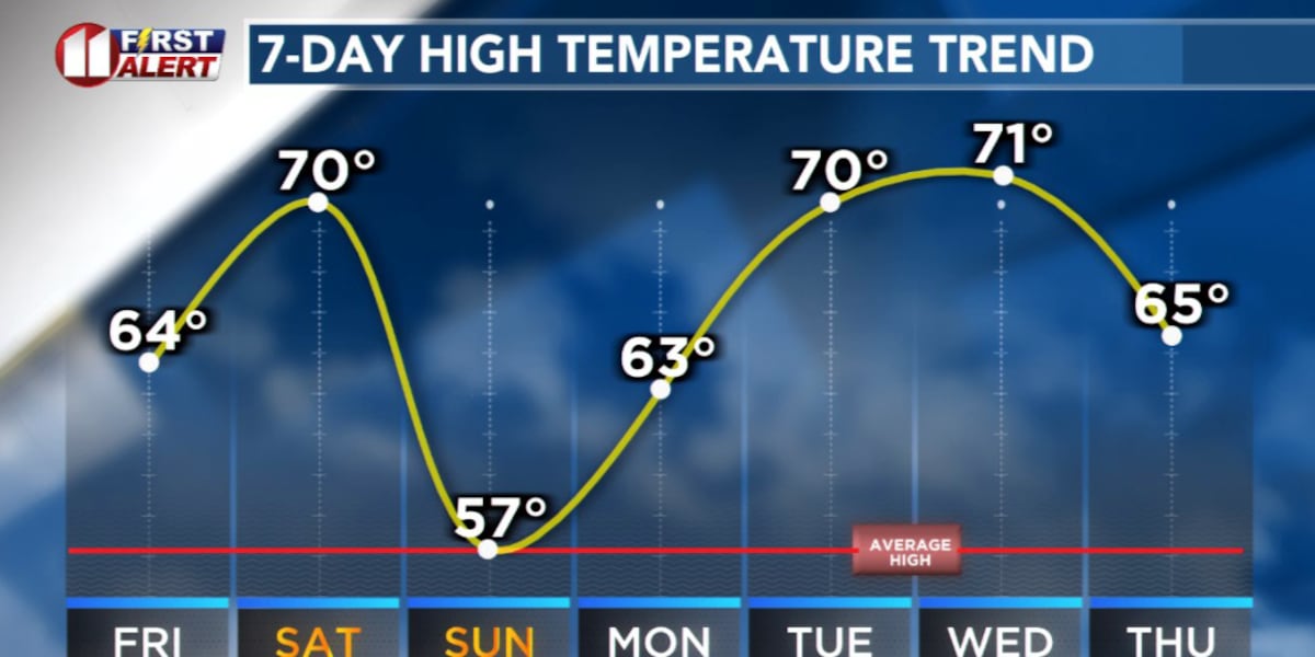
High temperatures will fluctuate during the week. They will, for the most part, remain above average for the time of year. The average high for Lubbock this time of year is around the mid-50s.
Relative to today, Tuesday will be a little windier. Westerly winds are likely to increase to 15 to 25 mph with stronger gusts in the afternoon.
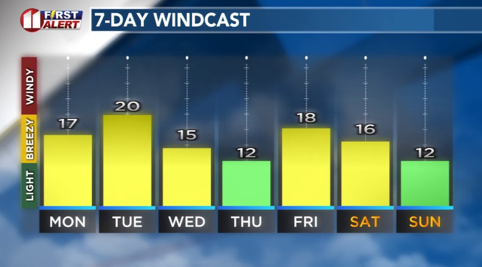 Breezy today and somewhat windy tomorrow.(KCBD First Alert)
The first of two cold fronts this week will arrive early Wednesday. It won’t pack much cold air. It will shift winds to the north.
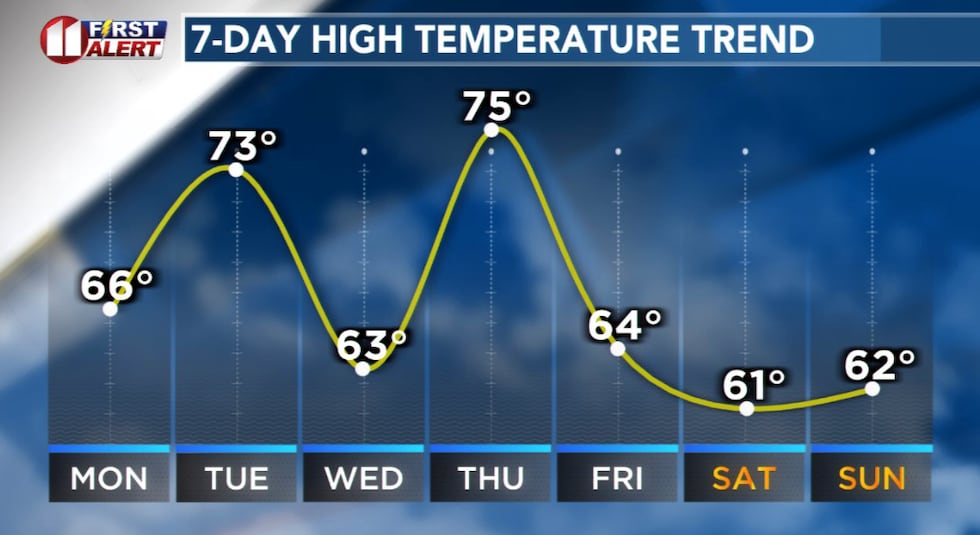 Temperatures will fluctuate during the week but, for the most part, will remain above average for the time of year.(KCBD First Alert)
The second and stronger cold fronts is expected Thursday night. Ahead of the front, southwesterly winds will help boost temperatures to the warmest of the week. Highs may range from around 15 to 20 degrees above average.
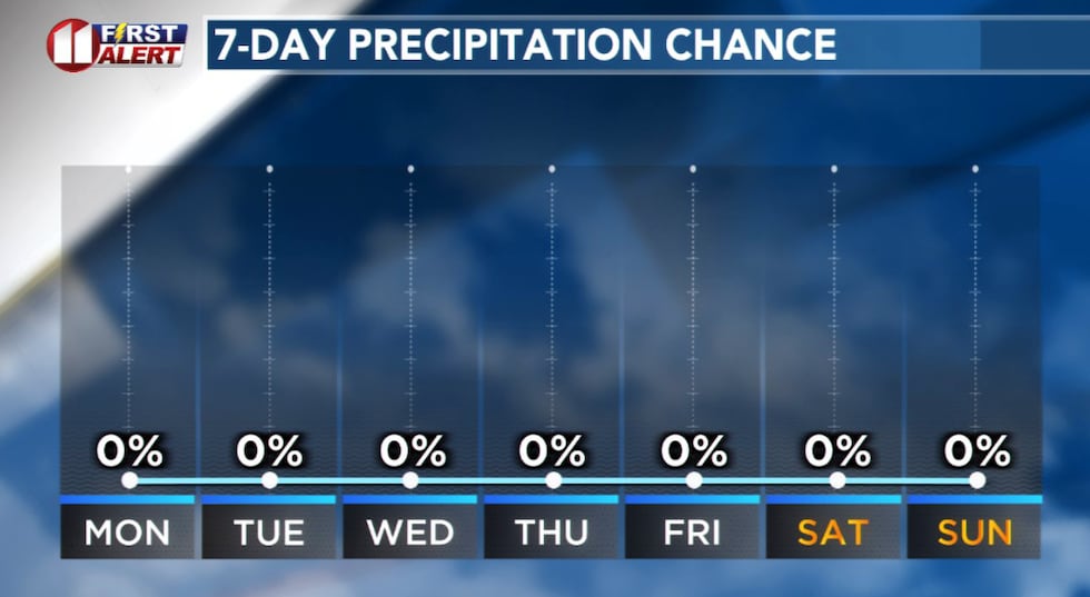 The dry pattern we’ve been in will continue through at least the weekend.(KCBD First Alert)
You can expect a noticeable decrease in warmth behind the front Friday and Saturday. That said, highs Friday and Saturday are anticipated to be near to slightly above average.
On This Date
On this date in 1999, cold air already in place set the stage for snow as a storm approached West Texas. Snow developed from west to east late in the evening, increasing in coverage and intensity on the 9th. Considerable thundersnow with snow rates up to two inches per hour occurred with accumulations of 4 to 6 inches occurred in Parmer, Castro, Swisher, Lamb, Hale, Hockley, and Lubbock Counties, with 1 to 3 inches widespread across the remainder of the KCBD/FOX34 viewing area. Some roads were closed in Castro and Parmer Counties with drifts up to 4 feet high.
(National Weather Service Lubbock)
Copyright 2025 KCBD. All rights reserved.