
LUBBOCK, Texas — Today will be warm and windy. Record-breaking temperatures combined with strong winds and critically dry conditions are leading to fire danger across the South Plains.
What to Expect Today
Saturday will feel more like late spring than late December. We expect the high in the low 80s. The current record for the date is 80, set in 1921. The warmest temperature recorded here in December is 83, set on December 6, 1939.
But the heat is only half the story.
Critical Fire Weather Conditions
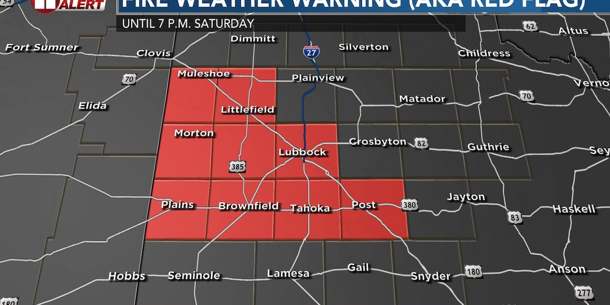
A Fire Weather Warning, also known as a Red Flag Warning, is in effect from 11 a.m. to 7 p.m. Saturday across the South Plains, including Muleshoe, Littlefield, Morton, Levelland, Lubbock, Plains, Brownfield, Tahoka and Post. This means conditions are critically dangerous for fire spread.
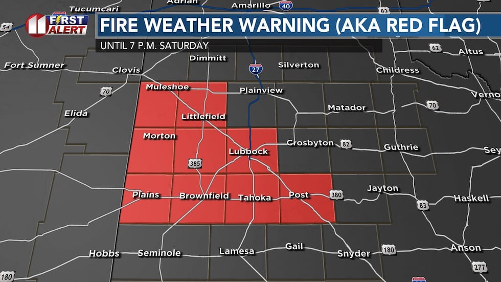 Fire weather warning also known as a red flag warning today for the counties highlighted in red, including Lubbock.(KCBD)
The wildfire risk is elevated all across the region. The warning area is where the worst combination of high wind and low humidity will be.
Here’s why: Southwest winds will ramp up to 30 mph today, especially across elevated areas. As temperatures climb during peak heating hours, humidity will plummet to dangerous lows — as low as 10 percent. Combine that with extremely dry vegetation, and you have a recipe for rapid fire spread.
The strongest wind will likely be first half of the day, out of the W/NW around 20-30mph.
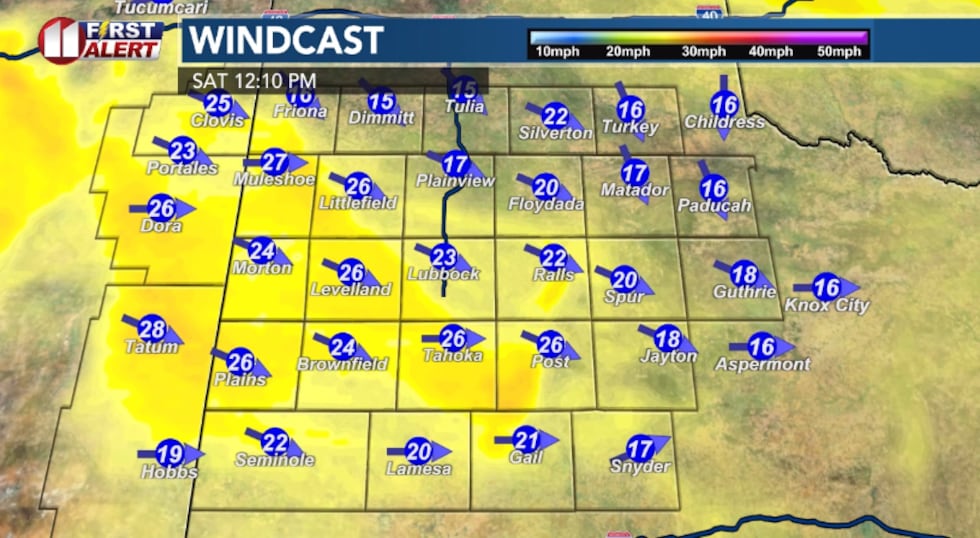 Computer model projection of wind speed Saturday(KCBD)
The wind may relax some by late afternoon, before a cold front arrives this evening, shifting the wind out of the NE 15-25mph.
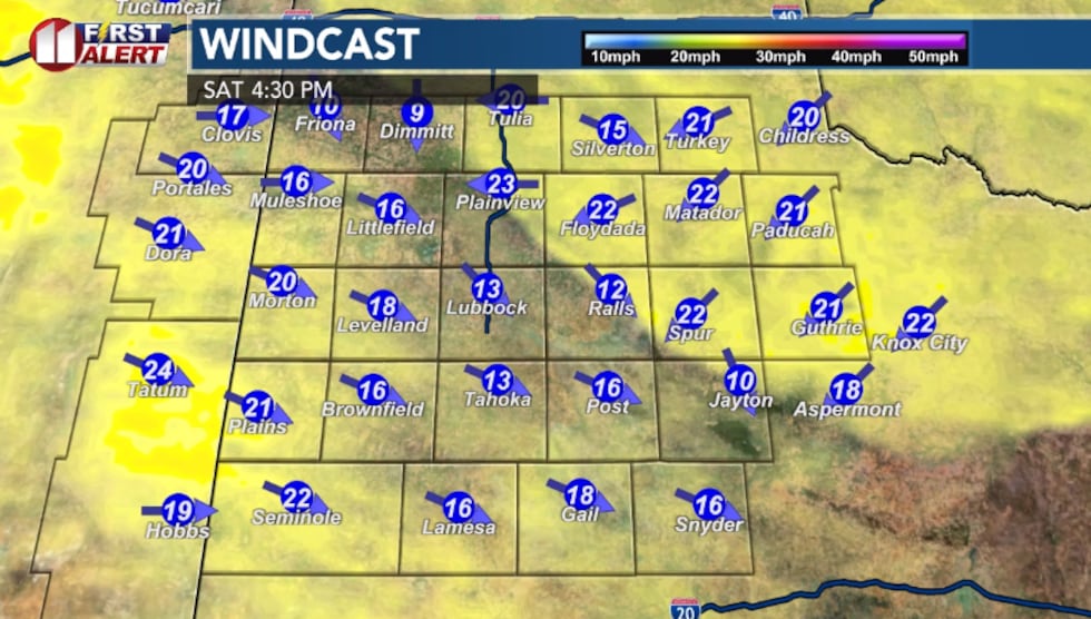 Computer model projection of wind speed Saturday(KCBD)
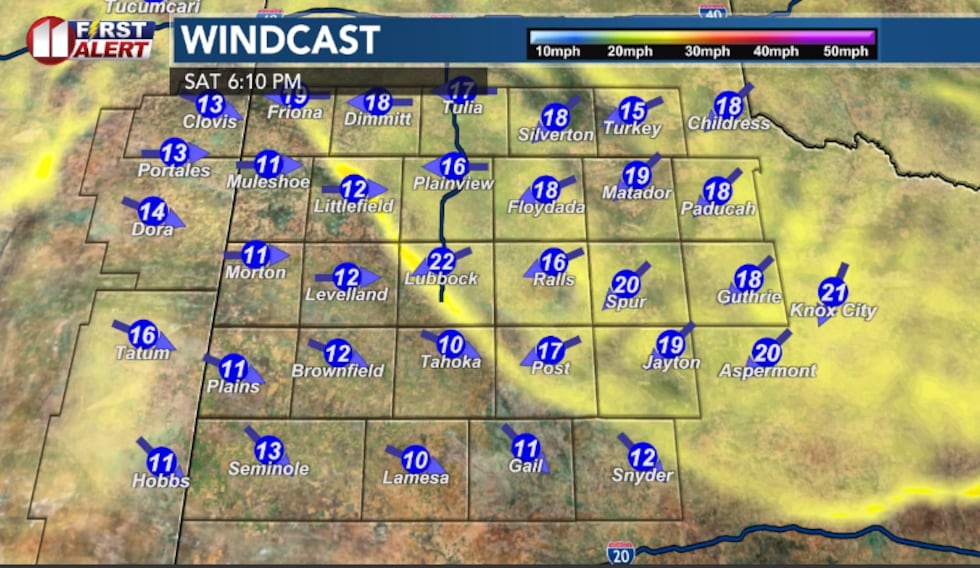 Computer model projection of wind speed Saturday(KCBD)
The wind will drop off tonight. Beneath a clear sky, the low will be in the low 30s.
What You Need to DoAvoid any outdoor burning or debris burning — this is not the day for itCheck on outdoor equipment that could spark a fireMonitor the KCBD First Alert Weather App for updates throughout the dayHave an evacuation plan ready if you live in fire-prone areasLooking Ahead
Sunday will bring a brief cooldown as a cold front moves through, with highs in the upper 50s and 60s. But don’t get too comfortable — warm and dry conditions will return for the holiday week, with highs climbing back into the 70s and 80s.
In fact, we will be near the record high for each date from Monday through Christmas Day and even the day after.
You can expand it from just San Antonio and list any city in our state, when singing George Strait’s “When It’s Christmas Time In Texas”. Because there won’t be snow.
It stays dry and sunny through next week. The pattern may shift cooler and slightly wetter toward the new year.
Copyright 2025 KCBD. All rights reserved.