
LUBBOCK, Texas (KCBD) – After a slight dip in temperatures yesterday, highs were still a little above average, unusually warm weather returns to West Texas today. Temperatures more common in Spring than early Winter dominate my forecast all week long.
The culprit, if you will, is the persistent high pressure area nearly stationary to the west of the KCBD/FOX34 viewing area. As it has done for weeks on end, and will continue to do this week, it deflects the storm track to the north of our area and, for the most part, blocks the seasonably coldest air from reaching West Texas.
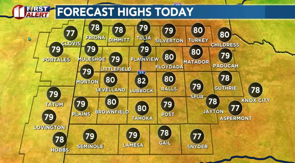 Temperatures today will peak 20 or more degrees above average for the time of year.(KCBD First Alert)
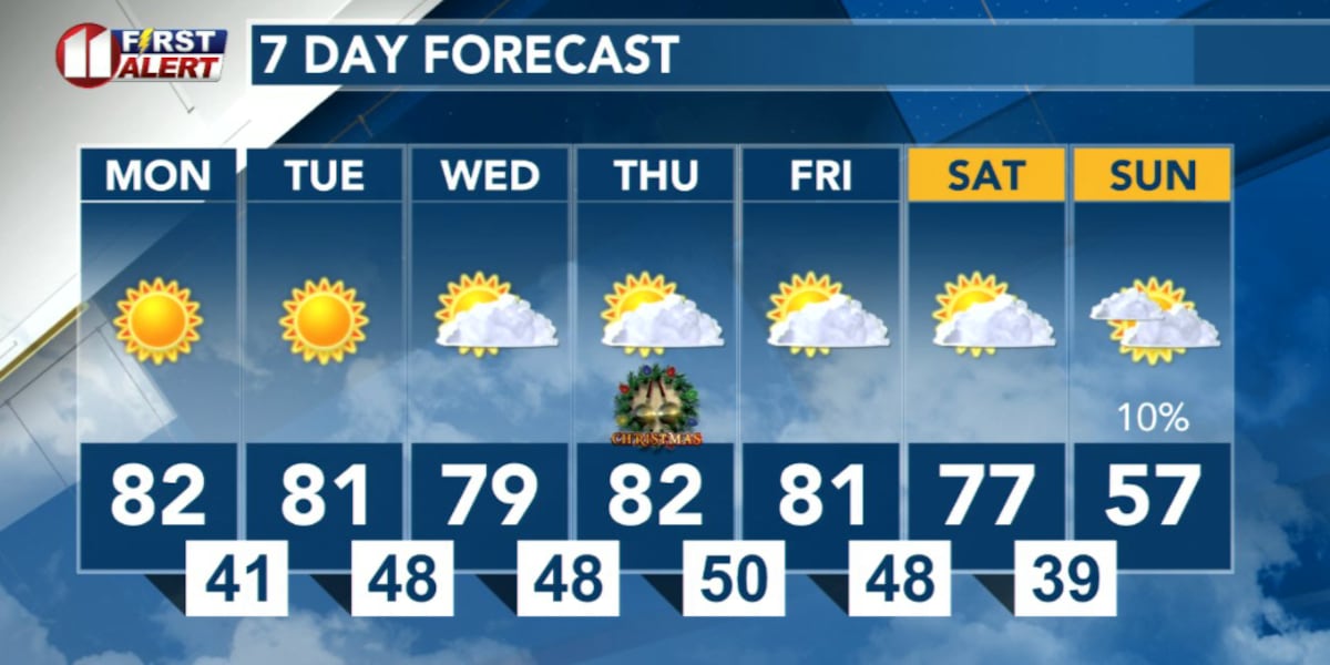
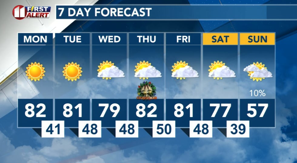
With that in mind, today temperatures will once again climb to well-above average for the date. Lubbock’s December 22 averages range from a low of 27° to a high of 54°. You can view the record for today, and each day this week, in the 7 Day Forecast here.
 Dry and unusually warm weather returns to West Texas today and dominate my forecast all week long.(KCBD First Alert)
Mostly fair skies will continue as well, with a few clouds from time to time.
There is, however, the possibility of fog over the southeastern viewing area late tonight into tomorrow morning and over much of the viewing area Tuesday night into Wednesday morning.
Winds most days will become slightly breezy, including Christmas Day and the holiday weekend.
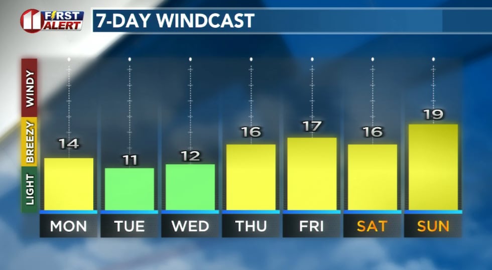 Forecast peak sustained winds are shown in this graph. Peak gusts will exceed the values shown here.(KCBD First Alert)
Dress for chilly evenings and mornings, but be ready to shed the light winter clothing for more light-weight “springy” attire.
Lubbock’s warmest Christmas was in 1955 with a high of 76°. The coldest Christmas Day, with the lowest high temperature, was in 1983 when the high was just 17°. The day before, Christmas Eve 1983, the high was just 8°.
Looking at Christmas low temperatures, the coldest was minus 1 degree in 1924. That’s just one degree shy of the all-time December record low of minus 2 degrees. That was recorded twice in December, on December 28 in 1924 and on December 22 in 1989.
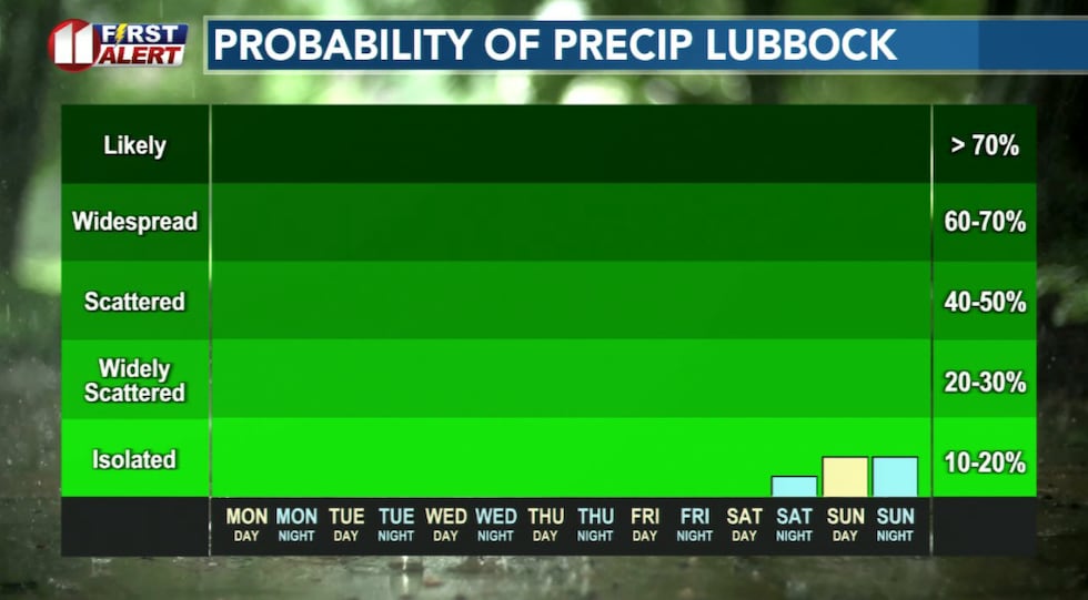 Meaningful precipitation is unlikely, but a few showers may follow a cold front Sunday.(KCBD First Alert)
The next cold front is anticipated late in the weekend. At this time, it appears to have the potential to drop temperatures to near average for the end of the year. It is unlikely to bring meaningful precipitation, but we’ll keep an eye on developments and potential changes to the forecast.
On This Date
On this date in 2004, widespread snowfall occurred across the South Plains of West Texas as a strong upper-level storm system collided with a southward moving Arctic air mass. Some of the heaviest snow totals measured: Lynn County… 5 to 6 inches, Garza County… 5 inches, Terry County… 4 to 5 inches, Yoakum County… 4 inches, Lubbock County… 3 to 4 inches, and Crosby County… 3 to 4 inches.
(National Weather Service Lubbock)
Copyright 2025 KCBD. All rights reserved.