
Sunday’s Recap:
HOUSTON – Sunday marked the start of winter with the Winter Solstice, but it did not feel like Winter. Instead Houston got another record breaking day.
Read more about the start of winter: Why there are two different days for the start of winter?
Another record breaking day ( IAH)Monday’s Forecast:
The warm, humid and foggy pattern continues as high pressure promotes an onshore flow. Watch for dense fog, that will lead to reduced visibility, especially near the coast each morning this week.
Monday will have highs once again in the 80s. There will be isolated to spotty showers, but not enough to wash anyone out or cool temperatures down.
Monday highs (Copyright 2025 by KPRC Click2Houston – All rights reserved.)
We’re under the influence of a strong dome of high pressure that allows plenty of moisture in from the Gulf but not any cooler air to move into place.
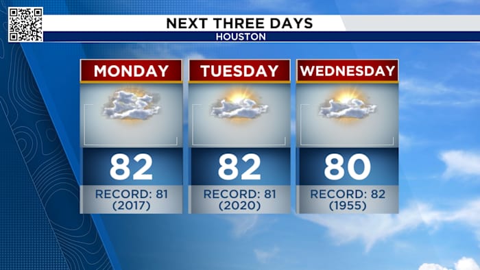
Next Three Days (Copyright 2025 by KPRC Click2Houston – All rights reserved.)
Last minute shoppers, the warm and foggy pattern continues. While you grab the gifts on the Christmas list in the afternoon, temperatures will push towards 80.
Christmas Forecast:
We’re in store for one of the warmest Christmas’ that we’ve seen in quite some time! Afternoons will be pushing close to 80 each day after foggy mornings.
Hot Christmas (Copyright 2025 by KPRC Click2Houston – All rights reserved.)
If we can hit 80, it’ll will be tied for the 3rd warmest Christmas ever! That’s quite a naughty list for us to be on but Santa better be ready with shorts and flip-flops this winter.
Record Christmas temps (Copyright 2025 by KPRC Click2Houston – All rights reserved.)Your Extended Forecast:
The next chance at a cooler temperatures doesn’t come until next Monday behind a cold front.
10-day forecast (Copyright 2025 by KPRC Click2Houston – All rights reserved.)
Stay up to date with the latest changes using Storm Tracker 2 radar and regular updates from the KPRC 2 Weather Team on Click2Houston.
Copyright 2025 by KPRC Click2Houston – All rights reserved.