
COURTESY CPHC
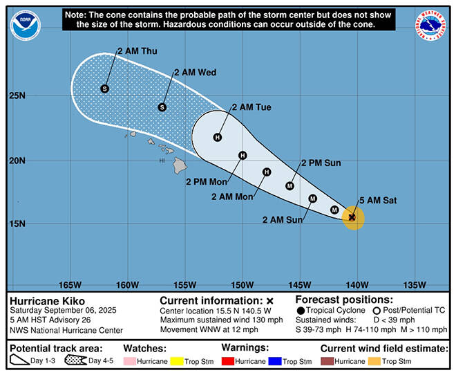
The five-day forecast track of Hurricane Kiko as of 5 a.m. today.
Hurricane Kiko entered the Central Pacific today as a compact but powerful Category 4 storm, however forecasters expect it to begin weakening Sunday as it heads north of the Hawaiian islands.
The latest five-day forecast track no longer has the islands in Kiko’s so-called cone of uncertainty, but the Central Pacific Hurricane Center in Honolulu stressed that people in Hawaii should continue to monitor its progress.
“Kiko’s current forecast track is north of the islands across the far northern offshore waters. While confidence is low concerning Kiko’s impacts to Hawaii early to mid next week, there is a possibly of higher statewide rainfall,” National Weather Service forecasters said.
At 5 a.m. today, Kiko had maximum sustained winds of 130 mph, moving west-northwest at 12 mph, and was centered 1,005 miles east-southeast of Hilo and 1,205 east-southeast of Honolulu, according to CPHC forecasters. Kiko’s hurricane-force winds extend up to 25 miles from the center and tropical storm-force winds up to 80 miles outward, they said.
“Kiko is forecast to approach the Hawaiian islands during the early to middle portion of next week. Impacts from rain and wind are possible over portions of the Islands, but it is still too soon to determine the exact location or magnitude of these potential impacts,” forecasters said.
RELATED STORY: State of emergency declared for Hawaii as Hurricane Kiko approaches
Don’t miss out on what’s happening!
Stay in touch with breaking news, as it happens, conveniently in your email inbox. It’s FREE!
The five-day forecast track has Kiko as a major hurricane through Sunday afternoon, but weakening to a Category 1 hurricane with 75 mph winds by Tuesday as it passes north of Oahu and a weak tropical storm by Thursday northwest of Kauai.
There are no Kiko-related advisories, watches or warnings for Hawaii, but forecasters said that swells generated by the hurricane are expected to begin reaching the Big Island and Maui by Sunday.
“These swells will gradually build and are forecast to peak along east-facing exposures of the Hawaiian Islands late Monday through midweek, potentially producing life-threatening surf and rip currents,” the CPHC said.
An Air Force Hurricane Hunter aircraft is scheduled to investigate Kiko today to provide a better look at the storm’s intensity and structure, officials said.
Hawaii’s weather this weekend, meanwhile, is expected to be dry and stable with highs in the upper-80s and lows in the mid-70s, according to the National Weather Service.
“Cloudier, warm and muggy island weather is forecast early next week under weakened trades,” forecasters said, adding that there will be a slight increase in rain shower frequency Sunday into Monday.