
FORECAST HIGHLIGHTS
ASTRONOMICAL FALL: Fall equinox occurred at 1:19pm
COOL FRONT: Arrives Wednesday afternoon – NOT hard hitting
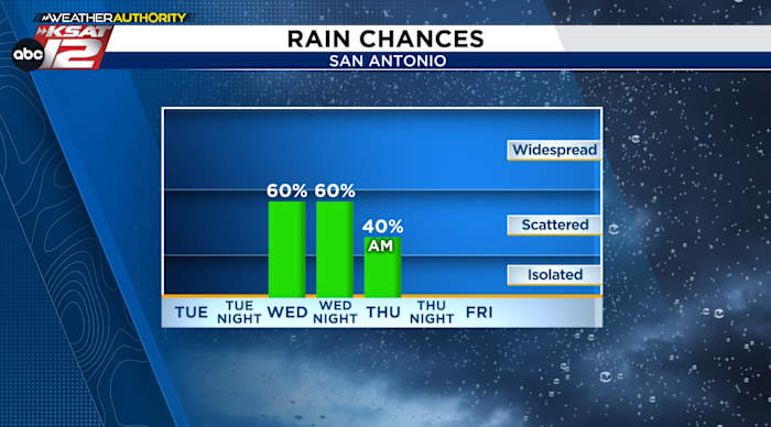
RAIN: 60% chance Wednesday afternoon into Wednesday night
CHANGES: Lower humidity and cool mornings (60s)
FORECAST
It’s officially Fall! The Autumnal Equinox occurred this afternoon at 1:19 pm. While it won’t feel like fall today or tomorrow, a weak cool front will arrive Wednesday, bringing with it the chance for rain.
CHANGES WEDNESDAY
A front arrives Wednesday afternoon for San Antonio (earlier in the Hill Country). This front will help to stir up scattered showers and storms.
A few of the storms could be strong with perhaps some quarter sized hail and gusty winds with any exceptionally strong storms.
While most of us will see less than an inch of rain, but street flooding is a possibility underneath the heavier downpours, where more than 1 to 2 inches of rain may fall.
Rain chances will linger into Wednesday night, before coming to an end early Thursday.
Here’s what we’re watching for with any strong storms that develop Wednesday evening. (Copyright 2025 by KSAT – All rights reserved.)
THURSDAY AND BEYOND
The front will drive in drier and cooler air by Thursday. This should clear skies fairly rapidly on Thursday. It also mean some beautiful mornings lie ahead. Lows in the mid-60s are forecast for Friday and Saturday mornings. Expect a dry forecast, until rain chances return early next week.
Cooler mornings and afternoon highs under 90° are on the way. (Copyright 2024 by KSAT – All rights reserved.)Daily Forecast
KSAT meteorologists keep you on top of the ever-changing South Texas weather.
QUICK WEATHER LINKS
Copyright 2025 by KSAT – All rights reserved.