
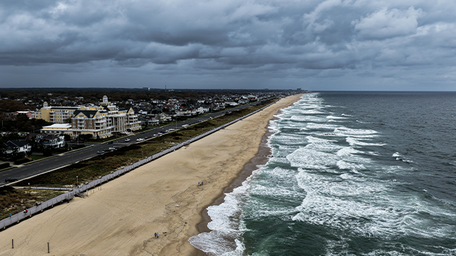
ATLANTIC CITY, N.J. – A powerful nor’easter making its way up the Eastern Seaboard is gaining strength as tens of millions of people from the mid-Atlantic to the Northeast and New England brace for heavy rain, damaging wind gusts and massive waves that have put coastal communities on alert for major flooding and beach erosion.
This comes after the storm slammed areas of the Southeast and Carolinas on Saturday, dumping several inches of rain and producing tropical-storm-force wind gusts from an already-battered North Carolina coast up to the Jersey Shore.
The persistent onshore winds brought yet another round of heavy surf, triggering 2-4 feet of coastal flooding in areas along the Outer Banks still reeling from multiple high-surf events through the past few weeks, leading to the collapse of several homes.
According to the North Carolina Department of Transportation, a portion of NC12 in Dare County between Marc Basnight Bridge and Rodanthe has been closed due to unsafe driving conditions brought on by ocean overwash. Officials are warning residents and visitors to not drive around barricades.
The FOX Forecast Center said that the core of the nor’easter is currently located in the mid-Atlantic, with heavy rain and strong winds continuing to batter communities in South Carolina, North Carolina and Virginia.
Impacts will only continue to surge to the north, with communities in Delaware, Maryland and New Jersey set to see impacts Sunday morning before the storm impacts areas like Long Island and New England as the weekend comes to a close and a new workweek begins.
Because of the expected major coastal flooding and flooding rain, Acting New Jersey Governor Tahesha Way said all 21 counties in New Jersey were in a statewide emergency that went into effect on Saturday due to the storm’s threat.
Download The Free Fox Weather App
“Starting on Sunday, a dangerous coastal storm will begin to move past our state with extreme weather conditions for several counties, especially those on the Shore,” Way said. “I urge all New Jerseyans to exercise caution, monitor local weather forecasts and warnings, stay informed on evacuation protocols, and remain off the roads unless absolutely necessary.”
The Delaware Emergency Management Agency (DEMA) has also urged residents there to monitor and prepare for the storm ahead of its expected impacts.
“We’re asking Delawareans to follow local directives to remain safe through the developing storm,” DEMA Director A.J. Schall said in a statement. “Take steps now to check your emergency kit, to clear gutters and secure outdoor furniture, to set aside some cash in case of loss of power, and to avoid nonessential travel during periods of heavy rain.”
Nor’easter Live Map Tracker: Radar, Storm Alerts, Wind Forecasts
In Maryland, officials had been urging residents to prepare for flooding that could mimic what was seen during Superstorm Sandy.
“As many of you know, a powerful storm, a nor’easter, is heading up the Atlantic coast and is going to have an impact on the Ocean City area,” Ocean City Mayor Richard Meehan said during a weekend news conference.
Meehan urged residents to take precautions and prepare for heavy rain, damaging wind gusts and flooding.
“These conditions will lead to flooded highways, flooded roadways and localized power outages,” he said. “We ask everybody to stay alert and avoid driving through standing water and keep safety as your top priority.”
Meehan used Superstorm Sandy to describe what residents need to do to prepare for impacts of the nor’easter.
“For our local residents, what I can tell you is that this storm could mimic what we received during Superstorm Sandy,” Meehan said. “I think we all remember the type of flooding we received. Just use this as a basis when you’re thinking about what to do to prepare you and your family for this storm.”
Tens of millions of people along a 500-mile stretch of the U.s. East Coast from the mid-Atlantic to New England remain under some type of coastal flood alert as the nor’easter inches up the coast toward the Northeast.
All five boroughs of New York City are among those in a Coastal Flood Warning.
The National Weather Service office in New York City is warning people of widespread moderate to major coastal flooding for the south shore bays of Nassau and southwestern Suffolk counties during times of high tide Sunday and into Monday.
In addition, damaging winds are expected across eastern portions of Long Island starting Sunday evening and lasting through early Monday.
Heavy rain is also expected, and the NWS said an average of 1-3 inches is expected, with the highest amounts being found closer to the coast.
Areas of minor urban flooding and poor-drainage flooding are also likely.
Winds are also a major concern for communities along the coast.
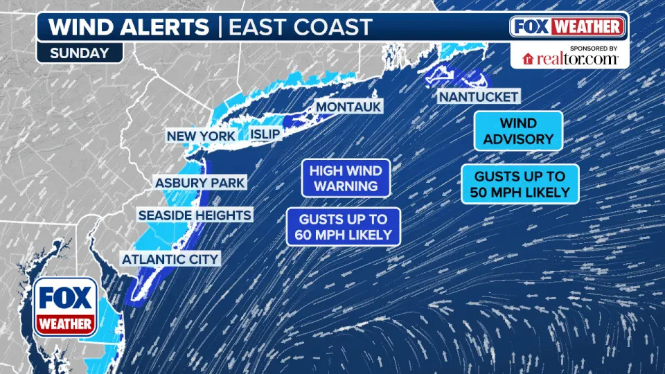
This graphic shows wind alerts in effect along the East Coast on Oct. 12, 2025.
High Wind Warnings are in effect for wind gusts of up to 60 mph from the Outer Banks of North Carolina northward to the Delmarva Peninsula and along the Jersey Shore and Long Island.
In Massachusetts, Martha’s Vineyard and Nantucket are also included in the High Wind Warnings. Other coastal locations along the East Coast are included in a Wind Advisory for wind gusts of up to 50 mph.
Original article source: Nor’easter slamming mid-Atlantic, Northeast leading to coastal flooding, tropical-storm-force wind gusts