
FORECAST HIGHLIGHTS
MORE HUMIDITY TODAY: Partly cloudy & sticky this afternoon
FRIDAY EVENING EVENTS: Should be safe, storms hold off until after 10pm
STRONG STORMS: Possible 12am-7am Saturday, a few more Saturday PM
FORECAST
MORE HUMIDITY TODAY
Humidity is increasing, giving us cloud cover this morning. The clouds will break up some this afternoon and it’ll be warm. Most of us will reach to near 90.
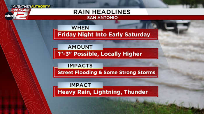
FRIDAY NIGHT STORMS
If you are planning to attend any Friday evening events know that most of the evening will be rain-free.
For now, the best odds of storms kicks in around midnight. At that point, a line or cluster of storms will make its way west to east across the area. Expect it to be bring plenty of lightning and thunder. However, there is a risk for severe wind gusts and heavy rainfall. Street flooding overnight Friday into early Saturday morning is possible. You’ll want to be very careful if you plan to travel pre-dawn on Saturday.
Future radar early Saturday morning (Copyright KSAT-12 2025 – All Rights Reserved)
MUERTOS FEST
Rain should clear the area Saturday morning, with some partial clearing by midday. However, redevelopment of storms will be possible Saturday evening. This activity will be more spotty. A few strong storms can’t be ruled out.
Sunday will see mostly sunny skies and much quieter conditions. Temperatures will return to the upper-80s.
Heavy overnight showers could produce a damp Muertos fest (Copyright KSAT-12 2025 – All Rights Reserved)
NEXT WEEK
The strongest front of the season, so far, will arrive by late Tuesday of next week. This will bring fall-like temperatures to the forecast by Wednesday.
8 Day Forecast (Copyright 2025 by KSAT – All rights reserved.)Daily Forecast
KSAT meteorologists keep you on top of the ever-changing South Texas weather.
QUICK WEATHER LINKS
Copyright 2025 by KSAT – All rights reserved.