When snow is in the forecast like it is this weekend, the first thing everyone wants to know is: How much am I going to get where I live?
We field these questions from readers all the time. And, like with our incoming first significant lake-effect snowfall of the season, it really does depend on which part of the state you live in. Our state is so big: Two peninsulas, touched by four of the five Great Lakes. Those things all factor into the snow forecast.
So we want you to check out the Probabilistic Precipitation Portal, an experimental forecast mapping system used by the National Weather Service which shows you how much snow will fall in different areas of the state.
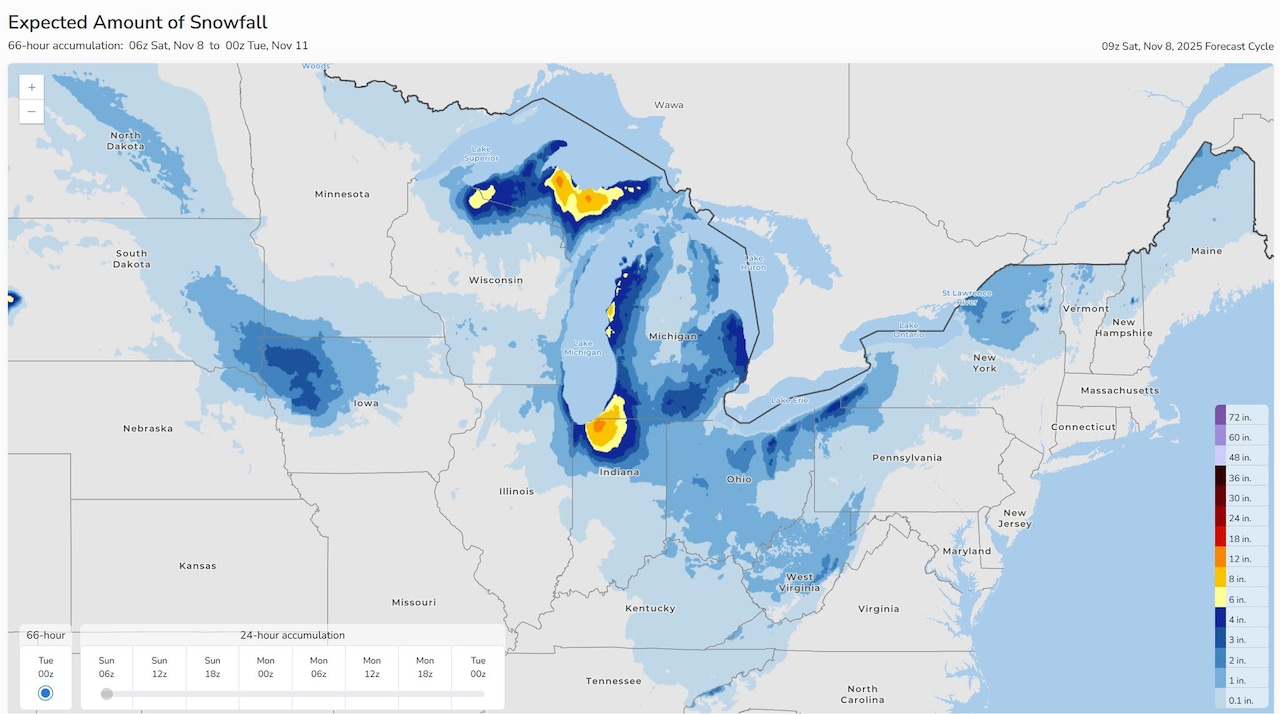
The NWS is touting the portal in the lead-up to our two-part weekend storm. Its colorful map shows the forecasted snow accumulations.
 The new Probabilistic Precipitation Portal forecast from the National Weather Service.Graphic provided by the National Weather Service
“Many areas will see their first notable snow of the season over the next few days in a chilly pattern,“ the NWS said today in sharing the map above. Heavier snow areas show in yellow, orange and red. ”Heavy lake effect snow is likely in portions of Michigan and Indiana. Totals shown here are through Monday evening, and rounds of lake effect snow are likely to continue into much of next week.“
We know Marquette and Alger counties in the Upper Peninsula are already under Winter Storm Warnings, with the forecast calling for up to a foot of snow – and maybe more.
Spots in the Lower Peninsula could also see several inches of snow stack up.
From the NWS team in Grand Rapids: “Looks like the lake effect will pile up in the usual locations, i.e., Big and Little Sable Points in western Mason and Oceana Counties and far southwest Lower Michigan including parts of Van Buren and Berrien counties.”
To see updates from the national Probabilistic Precipitation Portal, you can check the NWS website here. The map lets you really zero in on specific areas to see the exact snow totals in the forecast.
The weather service does offer the disclaimer that it’s an experimental product. The forecast uses a blend of weather forecasting models to come up with the most likely scenario in terms of snowfall.
The map offers a three-day snowfall range, which is nice for us to check out as we head more fully into winter later this month.
It’s also updated every hour, so you can see the snow tally forecast as it shifts and changes across the state as the forecast models are updated.
If you purchase a product or register for an account through a link on our site, we may receive compensation. By using this site, you consent to our User Agreement and agree that your clicks, interactions, and personal information may be collected, recorded, and/or stored by us and social media and other third-party partners in accordance with our Privacy Policy.
