

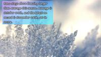
While it’s cold enough at night to wear a coat, Reno has yet to reach freezing this season. We’re a few weeks behind schedule, as Reno usually reaches freezing for the first time around October 19th. The airport, where climate data is recorded, is usually the warmest spot in town.
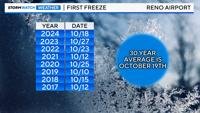
Even there, the average low this time of year is 31 degrees. The coldest low recorded at the airport this season is 33 degrees. This is not a reflection of the entire Reno area, as many neighborhoods reached freezing back in October. November 16th is the latest on record Reno has ever reached freezing. It was set back in 2016.
Minden, Virginia City, South Tahoe, Portola, and Tahoe City already fell below freezing this season. Places like Cold Springs, Galena, Arrowcreek, Spanish Springs, and Fernley reached freezing Saturday morning.
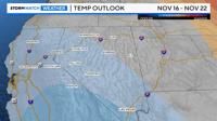
On the flip side, Reno could break the daily record of 74 degrees on Monday. We already broke the daily record last weekend with a high of 78 degrees on November 1st. Enjoy the warmer weather while it’s here! The extended forecast between November 16th and November 22nd is leaning cooler than average. Certainty is low, but there is a slight chance of cooler than average temps by the middle of the month.
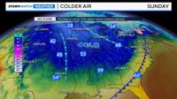
While those of us in the Truckee Meadows will be enjoying the mild weather on Sunday, many states along and east of the Rockies will be layering up in winter clothing for the remainder of the weekend. Parts of the Northern Plains, like Sioux Falls, South Dakota won’t even get out of the 20’s on Sunday. Dallas, Texas will be colder than Reno with highs in the lower to mid 50’s. Seems a bit backwards.