

Nearly all of New England has experienced a colder-than-normal November, with some decent early-season snow across portions of the northern mountains. We can expect more cold snaps that will most likely set us up for one of the coldest Decembers in years.
 Pockets of arctic air may push into the Eastern portions of the U.S. at the end of November and into the first week of December.Tropical Tidbits
A rare Sudden Stratospheric Warming (SSW) event is predicted to disrupt the polar vortex, forcing its bone-chilling air to spill southward and blanket the United States, including New England, after Thanksgiving and lasting until mid-December. Temperatures in our region could drop anywhere from 10 to 15 degrees below normal for this time of year.
Our area will remain on the fringe of these cold snaps, while areas west and southwest of New England will see temperatures slip 20 to 30 degrees below the average.
Now, it’s too early to say anything with certainty, but with pockets of cold air floating about the country over the next week or so, a winter storm may evolve. There’s nothing in the forecast yet for New England, but this event does raise eyebrows.
“The variability across such events is high, but if you are in the ‘sweet’ spot, (which is) dependent on your perspective, a region can experience a prolonged period of severe winter weather, such as multiple snowfall events and/or repeated cold air outbreaks,” said Judah Cohen, a research scientist at MIT and climatologist. “… This particular event is looking to be a polar vortex displacement, which, based on past events, is more prolific at delivering cold than blockbuster snowstorms, but certainly I wouldn’t rule it out.”
This SSW event is pretty rare this early in the season; they typically occur in the depths of winter or as we transition to spring. One takeaway from this slowdown of the polar vortex winds is the signal for an earlier arrival of winter for many folks.
This would be the earliest unstable polar vortex that the Northern Hemisphere has seen since the 1960s. Take a look at the temperature outlook across the country from the end of the month through Dec. 12.
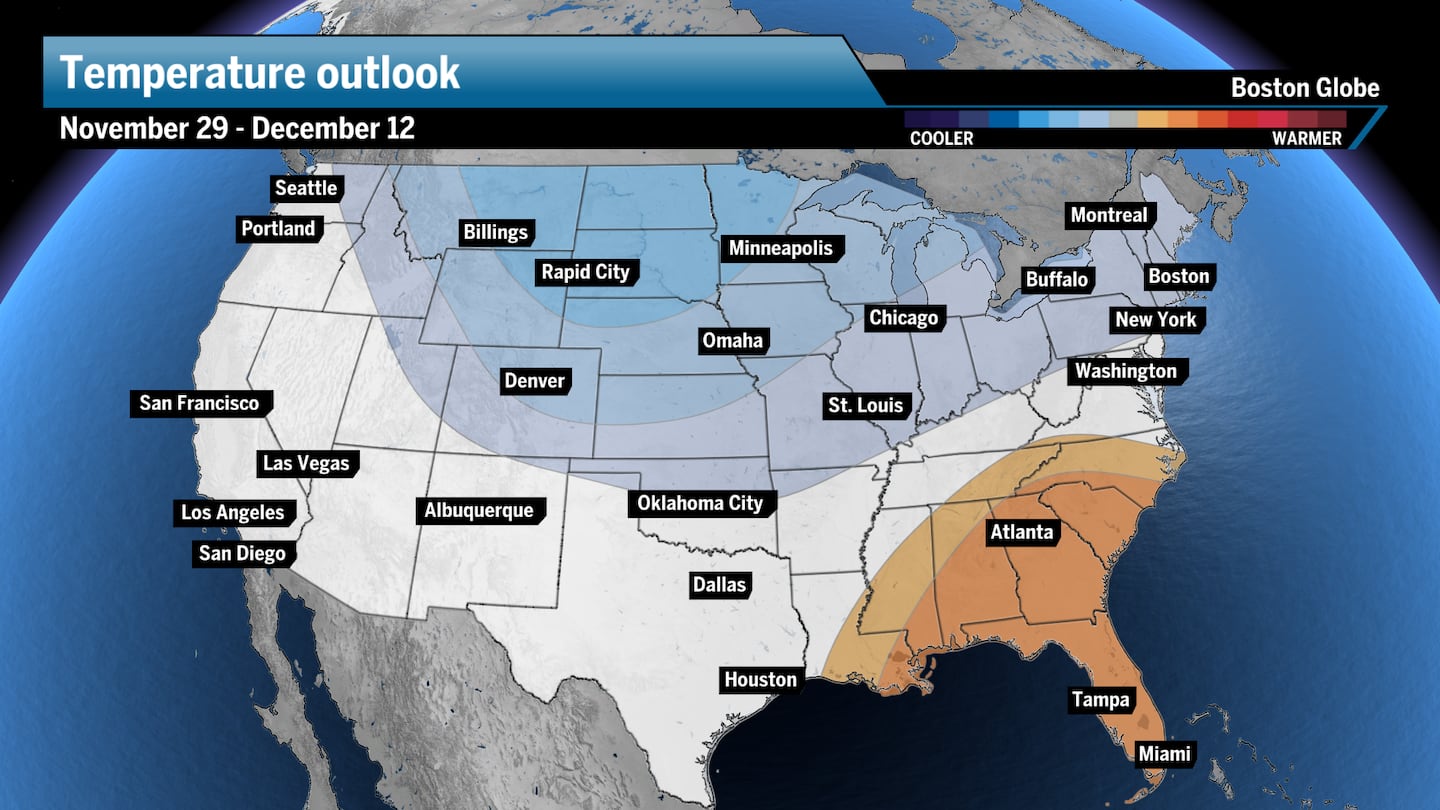 The northern tier of the country, including New England, may see colder-than-average temperatures from late November into mid-December.Boston Globe
How does Sudden Stratospheric Warming impact the polar vortex?
Simply put, if there is warming in the upper atmosphere, then the colder air that is usually in the stratosphere has to go somewhere. Most call this cold air movement “displacement.”
Sudden Stratospheric Warming (SSW) is a warming of the upper atmosphere, called the stratosphere. This is also where the polar vortex lives, miles above the surface — a tight band of wind that holds frigid air at the Earth’s poles. Our weather occurs in the troposphere, the layer of the atmosphere just below and closest to the surface.
The sudden warming of the stratosphere is a subtle but noteworthy because it’s the very first key to weakening and unlocking the polar vortex, which can break up and sling pockets of frigid air south into the U.S.
This is how it works: Changing wind speeds around the planet will push relatively warm air up against the polar vortex. This push will slow the winds while increasing temperatures. Think of a wave crashing against the beach. These “air waves” will break or crash across the vortex, where — if they’re as strong as I expect — wobbling, stretching, or even splitting of the polar vortex is possible. When this happens, cold air sinks to the surface and can migrate south.
This disruption of the polar vortex can cause the release of exceptionally cold air southward, sinking to the surface like “dripping paint,” according to Cohen, “as the tentacles, or influence from the sudden warming way up in the stratosphere, reach the surface multiple times.”
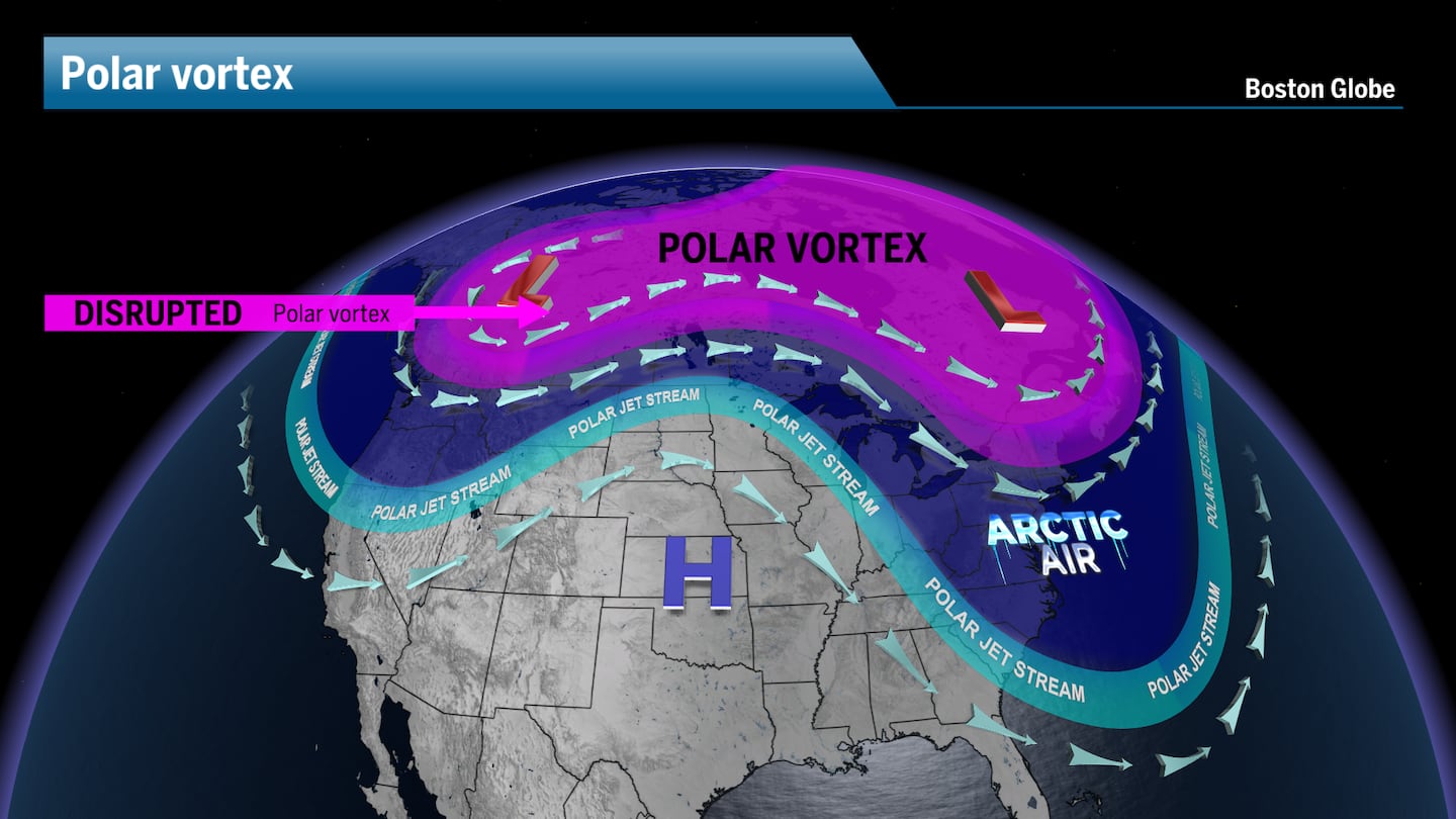 A disrupted polar vortex will send pockets of Arctic air south into the United States.Boston Globe
The exact weather pattern remains to be seen, but it does look like cold air will be pushed south across the country in a couple of waves, concentrating on the Midwest, Plains, and Southeast, sparing New England from the most brutal cold.
These upper-level weather events take some time to reach the surface, so I’m thinking we’ll see the bulk of the cold arrive in the first week of December.
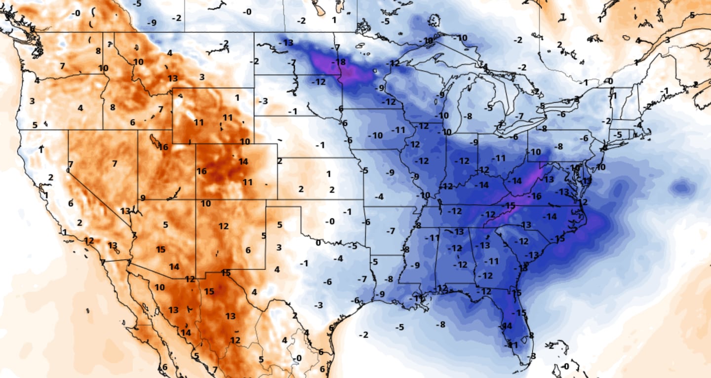 Temperatures will be 10 to 20 degrees below average for some on Friday.Pivotal Weather
With an unstable polar vortex, combined with other cold signals in the natural oscillations that dictate climate patterns, such as La Niña and the Madden-Julian Oscillation (MJO), we can expect more volatility in the weather, increasing the chances for cold spells and early-season winter snow and ice storms.
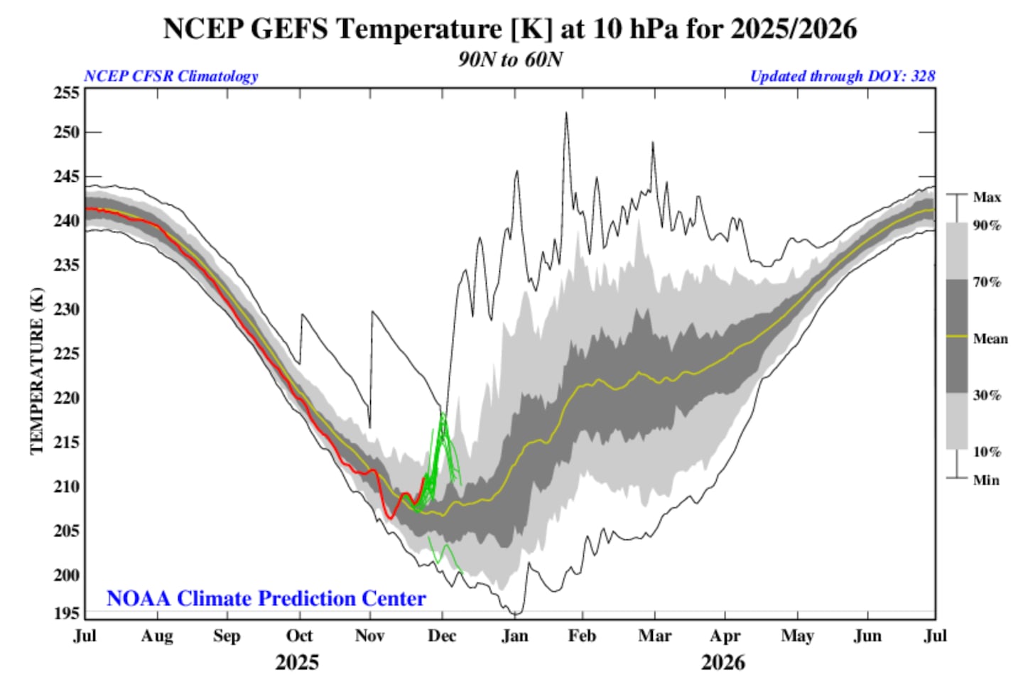 The forecast temperature in the stratosphere is expected to increase over the next week or so (marked in green), causing parts of the polar vortex to spill southward.NOAA
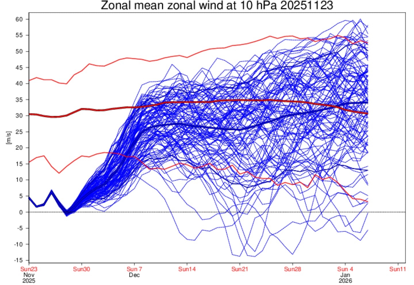
The European model does a great job of forecasting the average wind speed of the polar vortex. The concern here isn’t so much the stopping or reversal of wind direction (average forecast represented by the thick blue line). But take a look at how long the winds will be below average (thick red line). That means that colder-than-normal air may be moving into New England for a long stretch. Thankfully, this is happening in late November into December, versus January, or it would be dangerously cold for many Americans.
 The Polar Vortex wind may stop or reverse briefly by the end of Thanksgiving week.ECMWF
Cold air and snow go hand in hand, so perhaps we’re going to be forecasting snowstorms early and often this winter.
Sign up here for our daily Globe Weather Forecast that will arrive straight into your inbox bright and early each weekday morning.
Ken Mahan can be reached at ken.mahan@globe.com. Follow him on Instagram @kenmahantheweatherman.