
From rapid intensification to AI forecasting, this year’s hurricane season will go down in the record books.
ATLANTA, Georgia — As the 2025 Atlantic hurricane season closes on November 30, we’re looking back at a year that swung between long stretches of calm and sudden, powerful bursts of tropical activity. Even with several intense storms spinning up, the overall season landed right within NOAA’s predicted ranges for named storms, hurricanes, and major hurricanes.
One of the biggest storylines this year? Not a single hurricane made landfall in the United States. That’s something we haven’t seen in a decade.
“That was a much-needed break,” said NOAA Administrator Neil Jacobs. But he also pointed out that the U.S. didn’t escape impacts entirely. A tropical storm brought damage and tragic losses to the Carolinas, while strong hurricanes passing well offshore stirred up rough surf and caused coastal damage along parts of the East Coast. And of course, several of our neighbors in the Caribbean took direct hits.
This season also marked a major step forward in forecasting. According to NOAA, for the first time, the National Hurricane Center fully incorporated Artificial Intelligence model guidance into their operations. The NOAA administrator says that the upgrade helped forecasters excel at predicting rapid intensification, something we saw several storms do this year.
Season Stats at a Glance
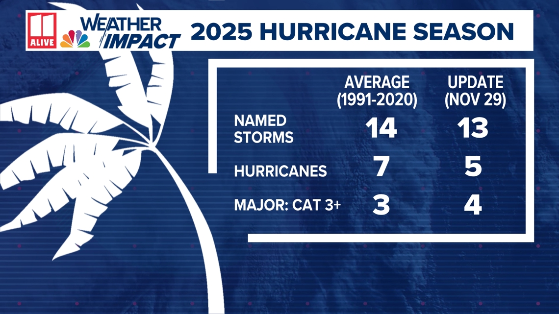
The Atlantic basin produced 13 named storms, five hurricanes, and four major hurricanes. That’s close to an average year, which typically brings 14 named storms, seven hurricanes, and three major hurricanes. But the numbers don’t tell the whole story.
Despite a quiet peak of the season, we saw three Category 5 hurricanes, which is the second-highest number on record. Luckily for the U.S., short-term weather patterns kept most systems curving away from the coastline.
Ken Graham, director of NOAA’s National Weather Service, praised the teams working behind the scenes. “Throughout the hurricane season, and all year long, the National Weather Service works around the clock to meet our mission of saving lives, protecting property and enhancing the national economy,” he said.

A Closer Look at the Key Storms
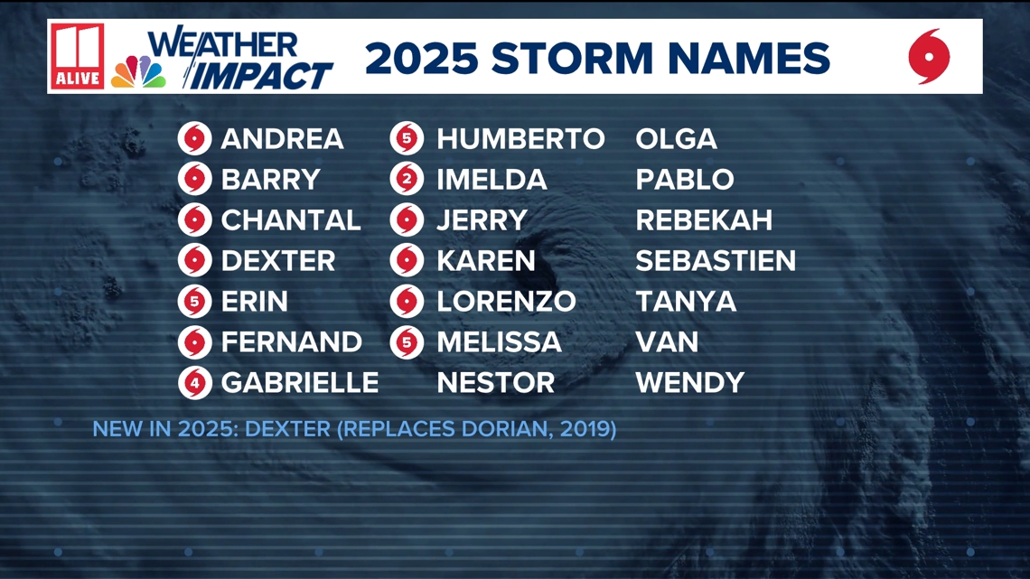
The season began with Tropical Storm Andrea on June 23. After that, tropical storms Barry and Chantal spun up quickly. Chantal became the only U.S. landfalling storm this year, dropping flooding rain across North Carolina.
Then came the heavy hitters:
Hurricane Erin became the first Category 5 storm of the season and produced dangerous surf and rip currents up and down the East Coast. Erin exploded from 75 mph to 160 mph in just 24 hours. The storm had one of the fastest intensification rates ever recorded.Hurricane Humberto followed as the second Category 5 storm.Hurricane Imelda developed shortly after, rounding out September’s activity.Hurricane Melissa arrived later as the third Category 5 hurricane of the season and one of the strongest landfalls ever seen in the Atlantic Basin. Melissa slammed into southwestern Jamaica on October 28, causing widespread destruction across Jamaica, Hispaniola, and eastern Cuba. Melissa also underwent an extreme burst of strengthening, jumping 115 mph in just three days.
The National Hurricane Center boasts that forecasting for Melissa was remarkably accurate. Four days before landfall, the NHC projected a track over western Jamaica and the storm ended up striking only about 13 miles off that early forecast. “NHC’s intensity forecasts for Melissa outperformed every model at nearly every lead time and provided almost three days of advance notice that Melissa would make landfall in Jamaica as a powerful Category 5 hurricane,” said NHC Director Michael Brennan. “This lead time was remarkable.”

Pacific Hurricane Season: Near Normal
Things were close to average in both the Eastern and Central Pacific basins. The Eastern Pacific produced 18 named storms, nine hurricanes, and three major hurricanes. Two named storms developed in the Central Pacific, with Hurricane Iona reaching major status south of Hawaii. Hurricanes Henriette and Kiko also crossed into the Central Pacific but passed northeast of the islands with little impact.
Behind the Scenes: A Huge Year for Hurricane Research
NOAA’s Hurricane Hunter aircraft flew more than 400 mission hours this season, including 53 trips through hurricane eyes, and deployed over 1,300 scientific instruments. Researchers gathered thousands of radar scans and more than 1,100 dropsonde measurements to support real-time forecasting.
This season also brought another historic first: an un-crewed surface vehicle successfully transmitted data from inside a Category 5 hurricane Humberto. According to NOAA, this gave scientists an unprecedented look inside the most dangerous part of the storm.
NOAA aircraft were also instrumental in damage surveys. After Hurricane Melissa hit Jamaica, crews collected nearly 15,000 high-resolution aerial images to assist recovery efforts.
What’s Next?
In the months ahead, NOAA’s National Hurricane Center will release detailed storm-by-storm analyses in its Tropical Cyclone Reports. These documents break down the science behind each storm and offer insight into forecasting improvements. They’ll be posted as they’re completed into early next year.
While the U.S. was fortunate this season, many communities across the Caribbean were not. The 2025 season serves as another reminder that even in an “average” year, it only takes one storm to change everything. As always, staying prepared and staying weather-aware is key.