
Oklahoma City is preparing for a winter storm expected to bring rain, ice, and snow late Wednesday into Thursday, potentially impacting commutes and schools.>> Go to the KOCO weather page | Get KOCO on the Go | Subscribe to KOCO 5’s YouTube channel6:05 a.m. Thursday Update: Norman Public Schools says it will be business as usual for students after the district evaluated neighborhoods, parking lots and sidewalks. While classes are still going on as scheduled, families were asked to use extra caution and bundle up. 6 a.m. Thursday Update: KOCO 5 First Alert Storm Chaser Nick Smith says snow is beginning to accumulate on bridges near Goldsby. He showed the slick conditions near I-35 and Ladd Road. Drivers should remain cautious on bridges as conditions could worsen throughout the morning. >> Video Below: Bridges conditions in Oklahoma begin to worsen5:35 a.m. Thursday Update: School announcements are starting to come in for Thursday. Mid-Del Public Schools announced it shift to remote learning. More information on closures can be found here. The Oklahoma Department of Transportation released an update on road conditions in the state. Crews are treating slick spots on highways, bridges and elevated surfaces, in western Oklahoma, primarily in Ellis, Roger Mills, Beckham, Harmon, Greer and Kiowa Counties. The department said I-40 from the Texas state line into the Oklahoma City metro is mainly wet, although crews are treating slick in spots closer to the Texas state line. ODOT crews in the Oklahoma City metro are treating bridges and overpasses and will continue to monitor conditions.5 a.m. Thursday Update: KOCO 5 Chief Meteorologist Damon Lane said Oklahoma City is snowfall as temperatures drop, raising concerns about road conditions and potential ice formation. Temperatures are working their way down, with colder conditions to the northwest where snow fell last night. There will be some issues that we have to watch. The roads in Oklahoma City are currently wet, but the situation could change in the coming hours.KOCO 5 First Alert Storm Chaser Nick Smith, reporting from I-240 near the airport, described the snowfall as the heaviest seen so far, with snowflakes as large as quarters. Despite the snowfall, no accidents have been reported on I-240.KOCO 5 Field Meteorologist Michael Armstrong in First Alert Storm Command saw moderate snowfall near Mustang, with light accumulation on the grass but wet roadways. The snow intensity varies across the metro area, with heavier bands setting up from Norman to Mustang and Tuttle. The northern parts of the metro are experiencing lower snow intensity. The forecast indicates an 80% chance of a rain-snow mix before 8 a.m., with potential snow accumulation mostly in grassy areas. However, snow and sleet showers could cause bridges to ice up between 6 and 8 a.m., a critical period to monitor.After 8 a.m., precipitation is expected to taper off, and roads should dry by tonight. A solid freeze is anticipated tomorrow morning, with temperatures dropping to 25-50 degrees for a high.>> Video Below: Oklahoma snow, ice update (5 a.m. Dec. 4, 2025)6 p.m. Wednesday Update: KOCO 5 Chief Meteorologist Damon Lane said the wet weather could move into the Oklahoma City metro around 3 a.m., with northern and western sides of the metro by 4 a.m. and 5 a.m., marking the changeover from rain to freezing precipitation.A winter weather advisory has been issued for much of central, northwest, southwest, southeast and western Oklahoma from 12 a.m. Thursday through 3 p.m. Thursday.The advisory was issued for Ellis, Woodward, Roger Mills, Dewey, Custer, Blaine, Beckham, Washita, Caddo, Canadian, Oklahoma, Lincoln, Grady, McClain, Cleveland, Pottawatomie, Seminole, Hughes, Harmon, Greer, Kiowa, Jackson and Comanche counties.There are expected to be some intense bands of snow from Hollis to Hobart coming through Norman, Shawnee, Seminole east by 7 a.m. Conditions could lead to a very slow commute and potential school closures before the snow begins to wrap up later in the morning and into the afternoon.Closer inspection into the metro again shows it starts out as rain and drizzle, changing over to ice from Edmond, Piedmont, Yukon, and then changes over to snow for Canadian and Oklahoma County. The winter weather should be in Cleveland, Grady and McClain counties between 5 to 6 a.m., with the heaviest snowfall expected as the morning commute begins.Activity starts to decrease by 9 a.m., with snow and freezing precipitation becoming much lighter, with a few passing snow showers after.Temperatures are only expected to climb into the 30s for most of the state on Thursday, with lows dropping down into the 20s.KOCO 5 First Alert Weather Team, led by Chief Meteorologist Damon Lane, has been certified by WeatheRate as providing the Most Accurate Forecast in Oklahoma City for 13 consecutive years. This outstanding achievement underscores KOCO 5’s unwavering dedication to delivering reliable weather forecasts to viewers.Be sure to download the KOCO 5 App to receive customized weather alerts. You can watch our team coverage on the app, too.>> Check Closings>> Check Live, Interactive Radar>> Watch KOCO 5 Coverage>> Download the KOCO 5 App on iPhone>> Download the KOCO 5 App on Android>> “Like” KOCO 5 on Facebook>> “Follow” KOCO 5 on X>> Stream KOCO 5 weather updates anytime on the Very Local app
Oklahoma City is preparing for a winter storm expected to bring rain, ice, and snow late Wednesday into Thursday, potentially impacting commutes and schools.
>> Go to the KOCO weather page | Get KOCO on the Go | Subscribe to KOCO 5’s YouTube channel
6:05 a.m. Thursday Update: Norman Public Schools says it will be business as usual for students after the district evaluated neighborhoods, parking lots and sidewalks. While classes are still going on as scheduled, families were asked to use extra caution and bundle up.
6 a.m. Thursday Update: KOCO 5 First Alert Storm Chaser Nick Smith says snow is beginning to accumulate on bridges near Goldsby. He showed the slick conditions near I-35 and Ladd Road.
Drivers should remain cautious on bridges as conditions could worsen throughout the morning.
>> Video Below: Bridges conditions in Oklahoma begin to worsen
5:35 a.m. Thursday Update: School announcements are starting to come in for Thursday. Mid-Del Public Schools announced it shift to remote learning. More information on closures can be found here.
The Oklahoma Department of Transportation released an update on road conditions in the state. Crews are treating slick spots on highways, bridges and elevated surfaces, in western Oklahoma, primarily in Ellis, Roger Mills, Beckham, Harmon, Greer and Kiowa Counties.
The department said I-40 from the Texas state line into the Oklahoma City metro is mainly wet, although crews are treating slick in spots closer to the Texas state line. ODOT crews in the Oklahoma City metro are treating bridges and overpasses and will continue to monitor conditions.
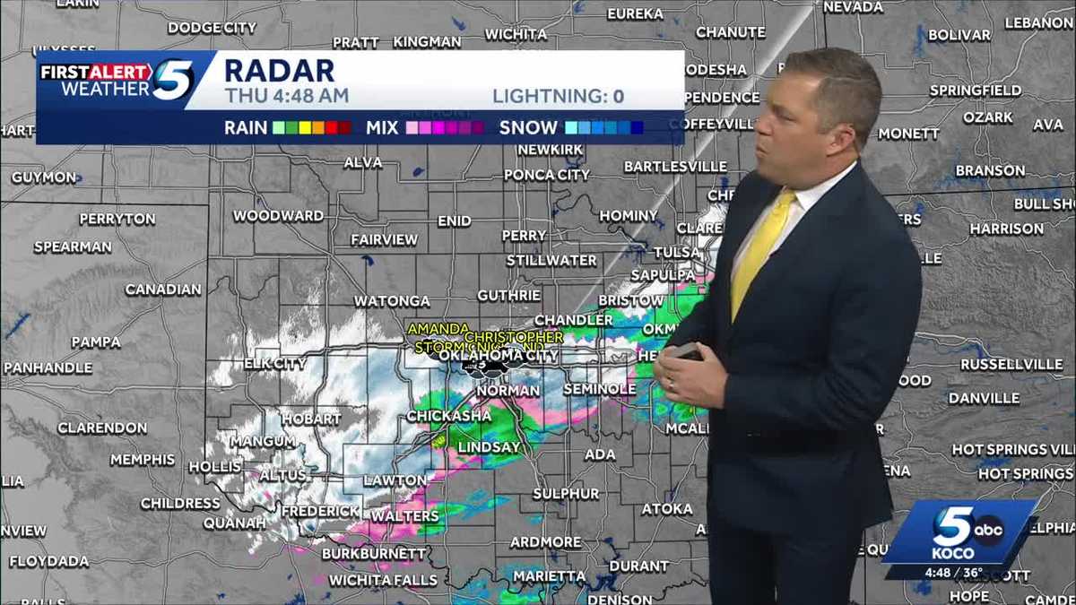
5 a.m. Thursday Update: KOCO 5 Chief Meteorologist Damon Lane said Oklahoma City is snowfall as temperatures drop, raising concerns about road conditions and potential ice formation. Temperatures are working their way down, with colder conditions to the northwest where snow fell last night.
There will be some issues that we have to watch. The roads in Oklahoma City are currently wet, but the situation could change in the coming hours.
KOCO 5 First Alert Storm Chaser Nick Smith, reporting from I-240 near the airport, described the snowfall as the heaviest seen so far, with snowflakes as large as quarters. Despite the snowfall, no accidents have been reported on I-240.
KOCO 5 Field Meteorologist Michael Armstrong in First Alert Storm Command saw moderate snowfall near Mustang, with light accumulation on the grass but wet roadways.
The snow intensity varies across the metro area, with heavier bands setting up from Norman to Mustang and Tuttle. The northern parts of the metro are experiencing lower snow intensity.
The forecast indicates an 80% chance of a rain-snow mix before 8 a.m., with potential snow accumulation mostly in grassy areas. However, snow and sleet showers could cause bridges to ice up between 6 and 8 a.m., a critical period to monitor.
After 8 a.m., precipitation is expected to taper off, and roads should dry by tonight. A solid freeze is anticipated tomorrow morning, with temperatures dropping to 25-50 degrees for a high.
>> Video Below: Oklahoma snow, ice update (5 a.m. Dec. 4, 2025)
6 p.m. Wednesday Update: KOCO 5 Chief Meteorologist Damon Lane said the wet weather could move into the Oklahoma City metro around 3 a.m., with northern and western sides of the metro by 4 a.m. and 5 a.m., marking the changeover from rain to freezing precipitation.
A winter weather advisory has been issued for much of central, northwest, southwest, southeast and western Oklahoma from 12 a.m. Thursday through 3 p.m. Thursday.
The advisory was issued for Ellis, Woodward, Roger Mills, Dewey, Custer, Blaine, Beckham, Washita, Caddo, Canadian, Oklahoma, Lincoln, Grady, McClain, Cleveland, Pottawatomie, Seminole, Hughes, Harmon, Greer, Kiowa, Jackson and Comanche counties.
There are expected to be some intense bands of snow from Hollis to Hobart coming through Norman, Shawnee, Seminole east by 7 a.m.
Conditions could lead to a very slow commute and potential school closures before the snow begins to wrap up later in the morning and into the afternoon.
Closer inspection into the metro again shows it starts out as rain and drizzle, changing over to ice from Edmond, Piedmont, Yukon, and then changes over to snow for Canadian and Oklahoma County.
The winter weather should be in Cleveland, Grady and McClain counties between 5 to 6 a.m., with the heaviest snowfall expected as the morning commute begins.
Activity starts to decrease by 9 a.m., with snow and freezing precipitation becoming much lighter, with a few passing snow showers after.
Temperatures are only expected to climb into the 30s for most of the state on Thursday, with lows dropping down into the 20s.
KOCO 5 First Alert Weather Team, led by Chief Meteorologist Damon Lane, has been certified by WeatheRate as providing the Most Accurate Forecast in Oklahoma City for 13 consecutive years. This outstanding achievement underscores KOCO 5’s unwavering dedication to delivering reliable weather forecasts to viewers.
Be sure to download the KOCO 5 App to receive customized weather alerts. You can watch our team coverage on the app, too.
>> Check Live, Interactive Radar
>> Download the KOCO 5 App on iPhone
>> Download the KOCO 5 App on Android
>> Stream KOCO 5 weather updates anytime on the Very Local app