
WASHINGTON — Western Washington will once again see very wet and breezy conditions tonight through Thursday morning.
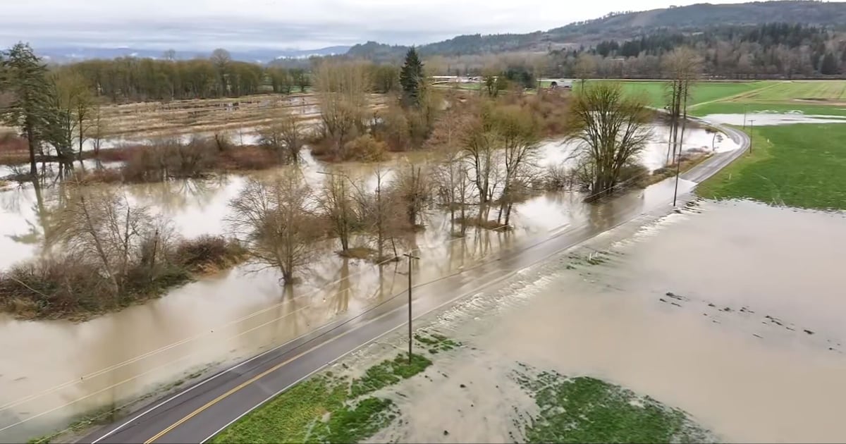
While overall rainfall might not be as heavy in spots as in Round 1 on Monday, this will last a bit longer, soils are completely saturated, and river systems cannot hold more water without flooding.

As rain moves back into the area tonight, another Wind Advisory will go into effect, with gusts in the 40-45 mph range from tonight through the day on Wednesday.
These winds will cause more issues with fallen trees, as soils are now saturated in many areas from 1-4 inches of lowland rain on Monday and Monday night. Power outages are likely to increase.
Then there is the rainfall and flooding threat. Some forecast models have this next round of rainfall topping out in the 2-4″ range in the lowlands from Tuesday night through Thursday morning with 5-10” in the mountains.
This is what we saw as an average through Sunday night and Monday, though drawn out over a longer period.
Still, there will be issues with urban flooding when the heaviest downpours hit, as storm drains are not equipped to handle the rainfall rates we’re likely to occasionally see.
Rivers will spike higher once again. Major flooding is expected on many of our river systems with crests higher than what we observed on Monday and into Tuesday.
Major flooding is expected on the following rivers with the following times of peak river levels (subject to change with new forecasts):
Puyallup River –
Will reach an even higher crest Wednesday morning at 10 a.m. in major flood stage.
Will crest again higher, but still in minor flood stage around 10 a.m. Wednesday
Snoqualmie River –
Next crest even higher in major flood stage at 58,000 cfs at 10 p.m. Wednesday, then quickly falling.
Falling overnight and then an even higher crest near 60 feet Thursday morning at 10 a.m. (about 2.2 feet below record.)
Tolt River –
Cresting in Major flood stage Wednesday afternoon, cresting around 4 p.m. Wednesday
Skykomish River –
Rises rapidly Wednesday morning to another higher major crest between 4-10pm Wednesday near 22.6 feet
Snohomish River –
Rises rapidly Wednesday morning reaching Major flood stage of 17 feet by Wednesday morning, rising to crest around 26.77 feet Thursday afternoon, about 1.5 feet above 1990 flood of record.
Rises rapidly to Major flood stage (29ft) by 5 pm WednesdayNear record flood stage from 9am Thursday to 7am Friday. Record flood stage from 1990 is 33.5 feet. The updated forecast has a crest at 33.8 feet.
Skagit River –
Rises rapidly Wednesday morning to reach Major flood stage at 32.5 feet by mid-morning Wednesday.Crests around 47.36 feet Thursday morning around 4 am. This would be more than five feet above the flood of record from 2003.
First crest at 10 pm tonight in Minor flood stage, then fallsRises rapidly Wednesday night reaching Major flood stage (32ft) by 10pm Wednesday, rising through the day to above record flood stage by Thursday morning.Crests at 4 am Friday at 41.54 feet, more than four feet above the record flood in 1990.
Cedar River –
in Renton
Reaches minor flood stage Wednesday afternoon reaching a crest of 17 feet Thursday morning, just shy of record level.
Other Rivers –
Tolt River at Carnation: Wednesday afternoonCarbon River near Fairfax: Wednesday afternoonNisqually River near National: Wednesday nightCowlitz River at Randle: in major flood stage now through Friday morningCowlitz River at Packwood: Wednesday morning
Some minor coastal flooding is also possible, especially near the time of high tide and near where rivers empty into the Salish Sea.
Drier weather will be in the forecast from Thursday afternoon through Friday and the weekend with most rivers dropping quickly into the weekend though hazards will still remain, with debris and dangerous river currents.
While the weekend’s weather looks calmer, there are prospects for more warm, wet, windy weather systems next week – possibly with some atmospheric river components.
It appears that we won’t have an end to the flooding threat in Western Washington through next week.
KIRO 7 will have live team coverage of this ongoing flooding threat through the event. Stay with us on-air and online.
©2025 Cox Media Group