
Something happened in San Francisco on Tuesday that hadn’t happened in nearly a month. It rained.
On Wednesday morning, weather stations across the Bay Area recorded their first measurable precipitation in 27 days. That’s an impressive streak, especially given it occurred during what are usually two of the wettest months of the year
It was the longest November-December dry stretch in nearly 40 years. But it likely won’t be remembered for long.
{ “__type”: “devHubFreeformEmbed”, “__id”: “Datawrapper”, “__fallbackImage”: “https://datawrapper.dwcdn.net/ZyHkr/mobile.png”, “__data”: { “datawrapper_id”: “ZyHkr” } }
Rain and snow, potentially a significant amount of both, are back in the forecast for the Bay Area and much of Northern California. Tuesday’s light rain was simply the announcement that the Pacific storm door is open again. After nearly four weeks without precipitation, San Francisco could see eight consecutive days of measurable rain starting Friday and lasting through Christmas.
That makes Thursday the likely final dry day before the holiday.
You’ll feel the shift even before the rain arrives, as moisture steadily increases on Thursday. The air will feel milder and slightly humid, a sharp contrast to a December that’s been colder than normal so far.
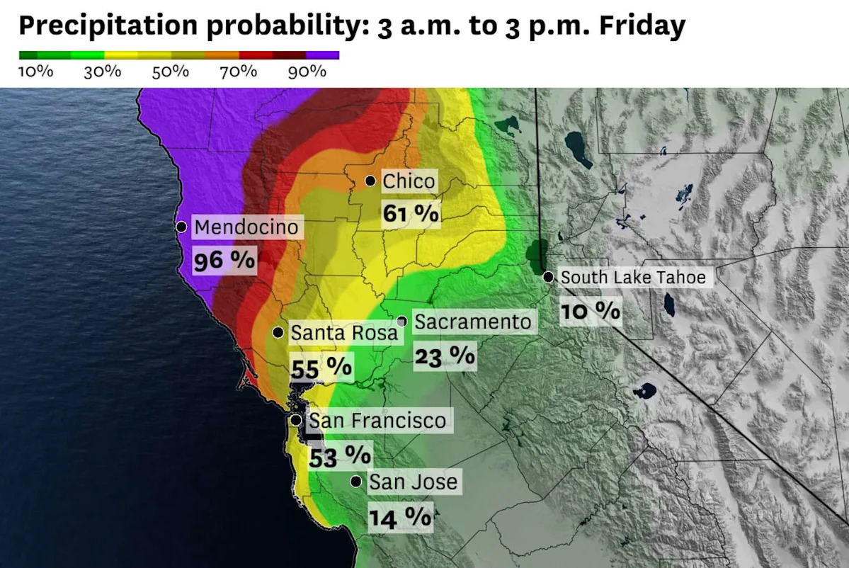
That increase in moisture is a classic signal of an atmospheric river – and that’s exactly what’s developing. Initially, the moisture plume is aimed at the Pacific Northwest, a region that doesn’t need more rain. But by Thursday it will slide south, bringing rain to Del Norte and Humboldt counties by Friday morning and into the Bay Area by Friday afternoon.
Friday afternoon looks wet around the Bay Area, something to keep in mind for holiday travel. There should be breaks in the rain, but Saturday night through Monday morning currently looks like the most active window. Sunday appears to be the worst day for travel.
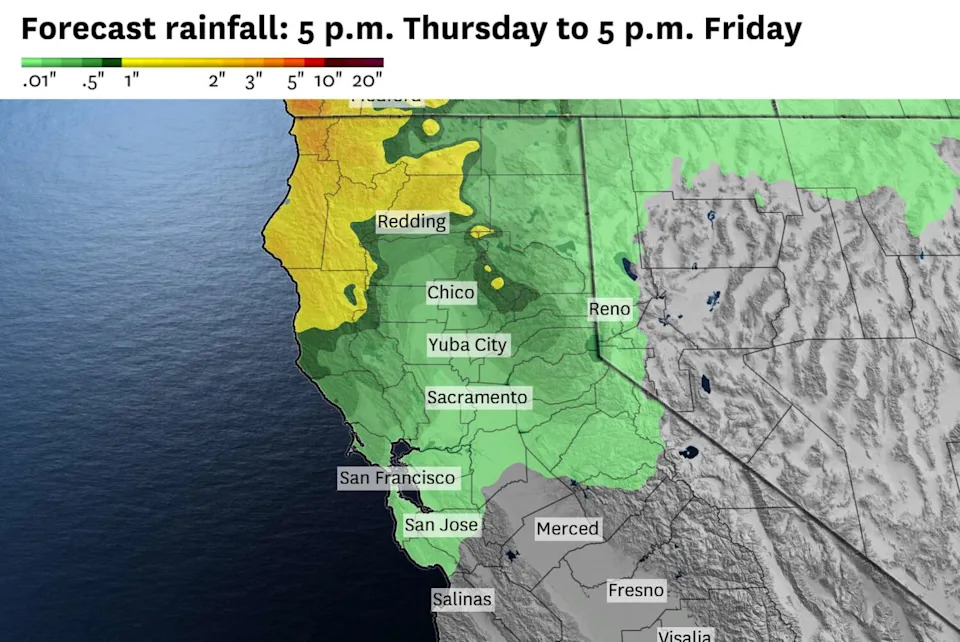
Forecasted rainfall amounts will be modest in the Bay Area, ranging from 0.25 to 0.5 inches of rain. Heavier rain is expected by Saturday night. (Baron/Lynx )
That highlights an important point about the stretch ahead. While it may technically rain every day through Christmas, it won’t be raining nonstop. There will be ebbs and lulls, depending on the placement of the atmospheric river.
This one is well sourced, a true Pineapple Express, stretching from the Pacific Coast back past Hawaii and originating less than 1,000 miles from the International Date Line. It’s tapping into an anomalously warm Pacific Ocean, giving it ample moisture and making it less likely to break down quickly.
That’s why, after the first wet stretch peaks from Sunday through Tuesday, a second and potentially stronger storm system could arrive around Christmas Eve.
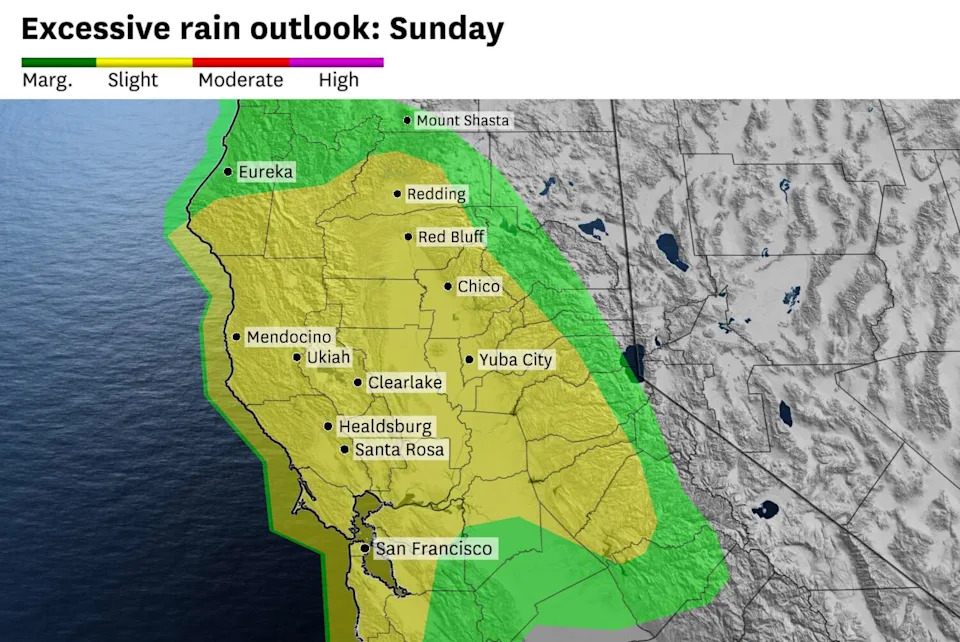
Saturday night through Monday morning looks like the timeframe for the heaviest rainfall with the first storm system, with Sunday being the wettest day. (Baron/Lynx )
What remains uncertain is exactly where the core of the moisture plume sets up. Those details often don’t come into focus until the storms are at the doorstep.
Still, we’re not flying blind. Forecast models can resolve the general placement of the atmospheric river, and we can lean on how similar setups have behaved in the past.
For now, the two main forecast models disagree. The European model shows a wetter solution, roughly 2 to 4 inches of rain through Tuesday across the Bay Area, with more possible around Christmas. The American model is notably drier.
The two models should come to a consensus in the next days, though it’s worth noting the American model has performed quite poorly in past months.
Thursday Bay Area breakdown
San Francisco: The day will start out with a plentiful amount of low clouds and fog in the city. Pockets of drizzle may pop up in the Twin Peaks and other high elevation spots. Otherwise, it’s a mostly cloudy day. Temperatures will be cooler than Wednesday, with highs in the mid- to upper 50s. But nearly 100% humidity levels will offset the drop in air temperature and it won’t feel particularly cold. Some sunshine in the afternoon helps a bit, too. Clouds and fog return overnight, with lows in the 50s.
North Bay: Parts of the North Bay will be hard-pressed for sunshine, especially along the Highway 101 corridor. Areas of patchy dense fog could slow the morning commute a bit before lifting in the afternoon. Still, it will remain mostly cloudy, with the best shot of sunshine east of Napa. Temperatures will be in the upper 50s with dew point values not far behind. It remains cloudy and mild overnight, with light showers approaching from the north in the predawn hours.
East Bay: Clouds and fog will be most persistent in the morning along the I-80/580 stretch through Berkeley. It’s likely to stay mostly cloudy along that stretch for much of the day, with some partial clearing in the Tri-Valley and Livermore valley. Temperatures will be in the low 60s across the board and feeling slightly humid. Overnight, the clouds and fog thicken closer to the bay, with temperatures holding in the upper 40s to low 50s.
Peninsula: Some areas of dense fog will linger around parts of Highway 101 in the morning. Parts of the Peninsula will see sunshine in the afternoon, as a weak bay breeze should keep the marine layer low clouds away. Places that are more likely to be stuck in cloud cover – like South San Francisco – will see temperatures in the upper 50s, while places with more sunshine potential – like Redwood City – will see highs in the low 60s. Then it’s set to be mostly cloudy and foggy again overnight, with lows in the upper 40s to around 50 degrees.
South Bay: Low clouds and areas of fog will persist through much of the morning in the South Bay. By the afternoon, sunshine will poke through those clouds in most spots. Temperatures will be mild with highs in the low to mid-60s. The region should be cloudy with patchy fog overnight, with lows in the 50s.
This article originally published at Northern California could see 8 straight days of rain. Here’s when it kicks off.